The Complete Guide to California National Parks
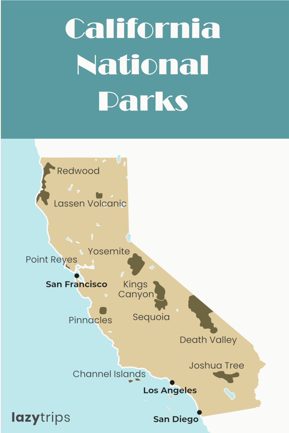
California has more National Parks than any other state. From arid deserts to dense forests and small islands, there is a lot of variety and thousands of miles of National Parks to explore.
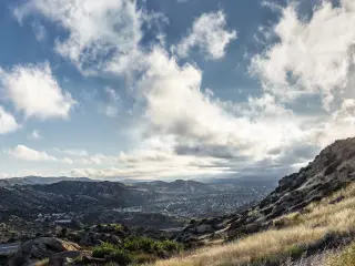
California has 10 National Parks - 2 in Southern California, 5 in Central California and 2 in Northern California. 8 of these protect land areas, Point Reyes National Seashore is a coastal preserve and Channel Islands are an offshore island group.
National Parks are the highest status areas of protected nature and wildlife in the United States. There are a number of other types of protected areas that have different statuses including National Forests, National Monuments, National Recreational Areas and National Historic Sites as well as state-level and local preservation areas.
Here is the list of the 10 National Parks in California with key details and our take on why you should visit them.
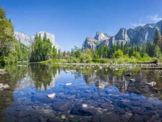
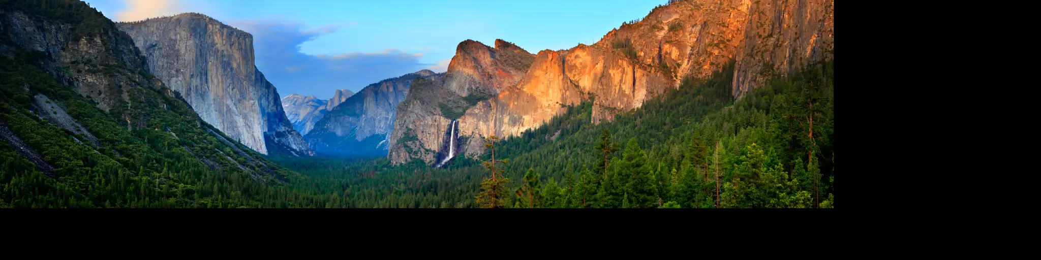
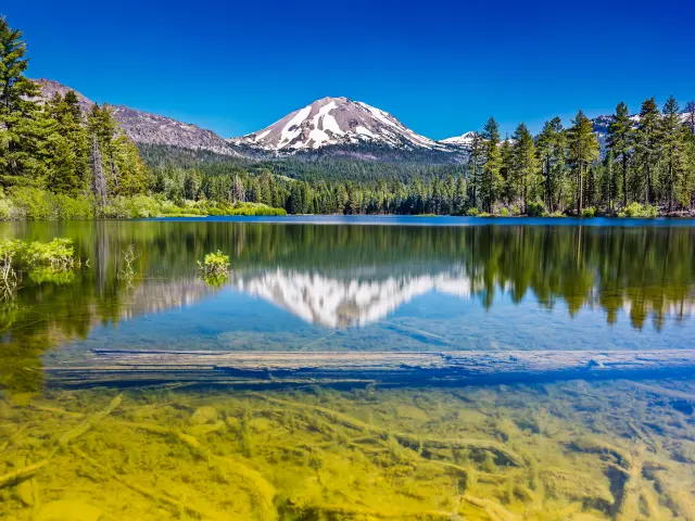
1. Yosemite National Park
Location: Sierra Nevada in Central California - 279 miles from Los Angeles, 167 miles from San Francisco
Stats: 1,169 square miles, 4 million visitors per year
Known for: Yosemite Valley with the El Capitan cliff
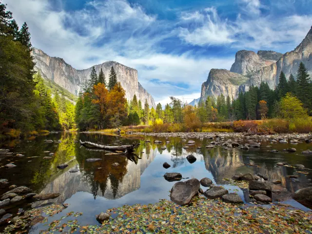
Yosemite National Park is the best known National Park in California and one of the most popular across the United States. Sitting right in the middle of the Sierra Nevada mountain range, you can visit it for a weekend from both, Los Angeles and San Francisco which adds to its popularity.
Although Yosemite is huge at over 1,000 square miles, the majority of the visitors visit the small Yosemite Valley area on the western side of the park. This is the area where El Capitan, the Half Dome and the Sentinel Dome are located as well as tourist facilities and different lodging options.
The park with distinctive granite mountains has 800 miles of trails and some amazing scenic roads. Highway 120 runs right across the width of the park, meeting Highway 395 at Mono Lake.
Remember that with the park being so popular, you need to plan ahead - booking accommodation or camping spots is essential, as is getting permits if you want to hike through the wilderness or even hike up the Half Dome. In fact, to get to the very top, you will have enter a draw and hope your number comes up on the day!
2. Kings Canyon National Park
Location: Southern Sierra Nevada - 240 miles from Los Angeles, 238 miles from San Francisco
Stats: 722 square miles, 699,000 visitors per year
Known for: Tall mountain peaks and the 1 mile deep Kings Canyon
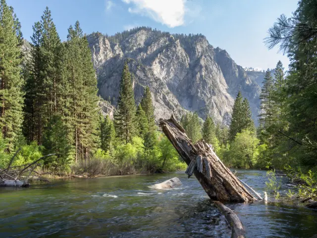
Kings Canyon National Park sits alongside its larger and more popular Sequoia National Park in southern Sierra Nevada and is about 240 miles from both, Los Angeles and San Francisco.
The park has one of the most striking landscapes with one of the country's largest giant sequoia forests, several mountain peaks topping 14,000 feet and deep glacier-formed canyons.
There are two broad areas in this wild park that you can get to by car - the Grant Grove and Cedar Grove parts. Grant Grove is home to a stand of giant sequoia trees that includes the second largest tree in the world - General Grant (The largest is in the Sequoia National Park a few miles south).
If you drive all the way to the end of the Kings Canyon Scenic Byway (which by the way is very scenic!), you can park up and walk to the Zumwalt Meadows. From the same spot, there are a few trails that run for miles north and south - if you want to camp wild, you can spend days exploring these and trek as far as the Devils Postpile National Monument above Mammoth Lakes, although that will take you at least a week to hike one way!
3. Sequoia National Park
Location: Southern Sierra Nevada - 204 miles from Los Angeles, 262 miles from San Francisco
Stats: 631 square miles, 1.2 million visitors per year
Known for: Having the largest tree in the world
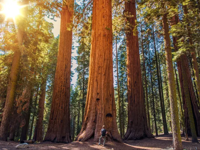
California's Sequoia National Park is the more popular and better known neighbor to the south of Kings Canyon. Receiving almost twice as many visitors, the world's largest tree, General Sherman, is one of the major attractions.
While the trees here are incredibly tall, they are not as tall as the coastal redwoods that grow closer to the Pacific. However, the sequoias that grow here are incredibly large - their trunks are unbelievably wide and some of the largest trees in the world grow in the park including the largest by volume, measuring 102.6 feet in circumference at the ground.
There are a few places you have to visit on your trip to the Sequoia National Park. The 400-step climb to the top of Moro Rock is well worth it for the incredible views that open up across the Sierra Nevada from the top.
While looking up at the sequoia tree tops, don't miss out on visiting the Crystal Cave. Among the traditional stalactites and stalagmites, there are bright colored rocks throughout making for an unforgettable visit.
On your way through the Giant Forest, near the Moro Rock Trail, follow the Crescent Meadow Road all the way to the end to enjoy a picnic with a view. On your way you'll pass through a car tunnel carved out of a giant sequoia - but be careful as it is only 8 feet (2.4m) tall!
4. Redwood National Park
Location: Northern California Coast - 685 miles from Los Angeles, 311 miles from San Francisco
Stats: 217 square miles, 483,000 visitors per year
Known for: Having the tallest tree in the world
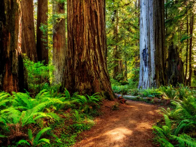
This small National Park sits along the Pacific coast and is over 5 hours' worth of pure driving time from San Francisco making it one of the more difficult parks to get to.
Getting there is seriously worth it though - this is the park that is home to the world's tallest trees including the absolute tallest Hyperion towering 379.1 feet (115.5m) above the ground. These coast redwood trees are much narrower than the giant sequoias found in the Sierra Nevada - hence the distinction between the largest and tallest tree records.
There are a number of nature sites near the Redwood National Park - Patricks Point State Park has amazing views over the coastline up and down from its elevated position and the Agate Beach is one of the most beautiful places to sit and watch the waves roll in.
Then there's the three natural lagoons, separated from the ocean by thin spits and the Redwood Highway snaking its way in-between all of these for one heck of a stunning drive.
5. Pinnacles National Park
Location: Central California - 268 miles from Los Angeles, 123 miles south of San Francisco
Stats: 42 square miles, 222,000 visitors per year
Known for: Talus caves that are home to over a dozen different bat species
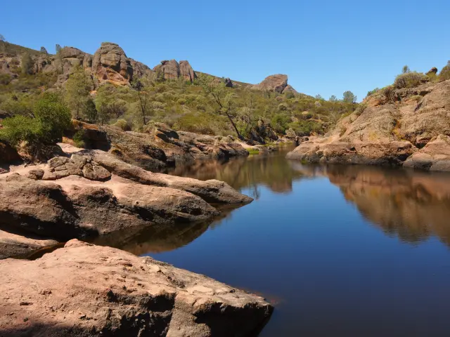
Pinnacles National Park is by far the smallest of the National Parks in California but also one of the most interesting ones you can visit, especially with it being relatively easy to get to from major Californian cities.
The Pinnacles are remains of an ancient extinct volcano which is what gives the rock formations their unique look. The actual volcano formed about 200 miles away from where the Pinnacles National Park is located, but the rocks are moving away from the site at up to 6cm a year due to tectonic movements.
The park was first designated as a National Monument and upgraded to become a National Park in 2012-2013. Despite its small size, there are a few interesting things to see.
First off, it is one of the only places in the world where you can see the Californian Condor in the wild alongside prairie falcons. Then there are the 13 different bat species that live in the talus caves that formed when rocks from above fell into a narrow gorge forming these unusual structures.
6. Death Valley National Park
Location: Great Basin on the California-Nevada border - 214 miles from Los Angeles, 467 miles from San Francisco
Stats: 5,262 square miles, 1.7 million visitors per year
Known for: Being the hottest place on Earth
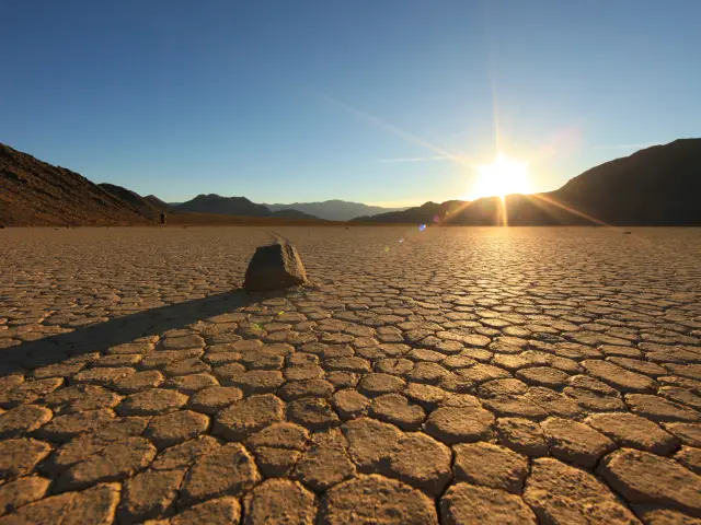
The Death Valley National Park sits along the California - Nevada border in the northern Mojave desert.
The desolate landscape has a mix of different desert types and features - there's rocky hills, dried out lake beds, long patches of hard flat sand and even large sand dunes in different parts of the National Park.
Known for being the hottest place on Earth with the absolute temperature record dating back to 1913 and the hottest average month on record in 2018, Death Valley is best avoided during the peak summer months when it is virtually impossible to spend any time outside during daytime with temperatures averaging over 120 °F (50 °C) from June to August.
Despite the proximity of what might be the brightest city in the world in Las Vegas, Death Valley National Park is known for having one of the darkest skies in the United States. If you head towards the north of the park, the entire area is a designated dark sky area where you can see the stars light up and the sky and not only see Milky Way but clearly see a few other galaxies at night with just your eyes.
7. Joshua Tree National Park
Location: Southeastern California, near Palm Springs - 131 miles from Los Angeles, 501 miles from San Francisco
Stats: 1,235 square miles, 2.9 million visitors per year
Known for: The distinctive Joshua Trees that grow throughout the park
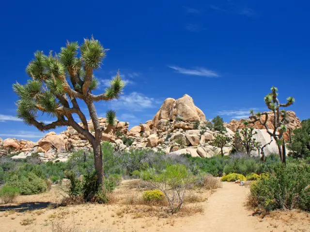
Joshua Tree National Park is the closest National Park to Los Angeles and San Diego and is a highly popular destination for those looking to escape the city for a weekend tuning into nature.
The temperatures are a lot more mild than other deserts in California with average highs during the summer peaking in the high 90s (36 °C) and night-time temperatures dropping into the 60s (below 20 °C). This means that camping in the desert is popular and so in fact so popular that there are over 300 camping sites and 9 larger campgrounds with facilities to choose from.
Hiking through the park leads through different landscapes with rock formations splitting up the desert - there are many to see with some of the better known ones being the Old Woman Rock, the Giant Marbles and the Arch Rock in the White Tank campground.
With over half of the Joshua Tree National Park being designated wilderness, make sure you bring everything you need with you - there are no facilities, no shops, no water or food. You'll need to respect the wilderness too - local rules forbid open fires and you'll need to register with the NPS if you want to camp out in the wild.
8. Lassen Volcanic National Park
Location: Northern California, 575 miles from Los Angeles, 248 miles from San Francisco
Stats: 166 square miles, 499,000 visitors per year
Known for: Lassen Peak - the largest plug dome volcano in the world and the Volcanic Legacy Scenic Byway
Lassen Volcanic National Park in northern Sierra Nevada is a spectacular exhibit of nature - you've got lakes, mountains, every type of volcano that exists, bears and mountain lions.
Lassen Peak is the tallest point of the park and is a huge active volcano that towers above the entire area. It is one of two volcanoes that have erupted in the United States in the 20th century along with Mount St. Helens further north in Washington State.
The entire area continues to be very geologically active - there are hot springs, steam coming out through the ground and hot mud pots. Stay on the roads and official trails at all times - that firm ground may be not so firm and much hotter than it looks.
Other than Lassen, another volcano in the park that's worth seeing is Cinder Cone. The volcanic dome and crater are built up of ash that came out during the eruption creating a giant black pile.
You can hike up to the top to see not just inside the volcano, but most of the park as well. The hike is not the easiest so come prepared and you will be rewarded when you get to the top!
You can only access the park from July to October when the snow has melted and the roads open up. You can still get to parts of the park in the winter, but you'll have to start much further out and it's difficult to get through to the center.
One thing not to miss when you come is the phenomenal road that was built in the early 20th century through the park. Lassen Peak Highway is one of the most stunning roads in California and the whole of the United States.
Your navigator will likely take you to Manzanita Lake - don't head back before you've driven north and south (the best views are going south) from there along the highway!
9. Channel Islands National Park
Location: Southern California, just off Ventura and Oxnard - 68 miles from Los Angeles, 357 miles from San Francisco (+ a ferry)
Stats: 390 square miles, 366,000 visitors per year
Known for: Sea caves and rocky coves
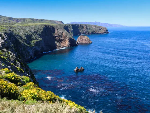
The Channel Islands is a group of 8 islands off the coast of Southern California, near the cities of Santa Barbara and Ventura. These windswept islands are home to many species of plants, birds and fish and you may even spot animals that include the small deer mouse or the island fox.
Over 100 animal species that live on or around the islands are endemic and only exist on these islands, not to be found anywhere else in the world.
Temperatures are consistently mild throughout the year with daily highs ranging from 63.4 °F (17.4 °C) in February to 76.7 °F (24.8 °C) in August. The summer months are very dry and even in the middle of the winter, there is not a lot of rain which means that the islands are great to visit in the spring and fall with most tourists coming over the summer months.
Once you've paid for your ferry, the park has no entrance fee and you're free to explore it on food or in a kayak. Known for the many small nooks and crannies around the perimeters of the islands, there are some stunningly beautiful spots where you can find seals and sea lions relaxing on the rocks.
If you're lucky, a group of dolphins will come and find you and swim alongside you. At certain times of the year, blue whales also turn up to the islands and you can see them coming up for air from the coast.
You can stay overnight on the islands, but you'll have to camp. If you want the luxuries of a hotel room, you'll have to get a boat back to the mainland and stay in Ventura.
10. Point Reyes National Seashore
Location: Pacific coast - 427 miles from Los Angeles, 48 miles north of San Francisco
Stats: 111 square miles, 2.4 million visitors per year
Known for: The only protected National Seashore on the west coast of the United States
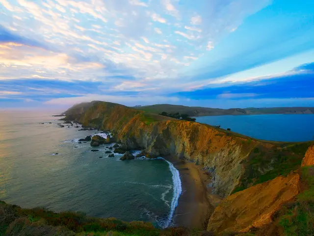
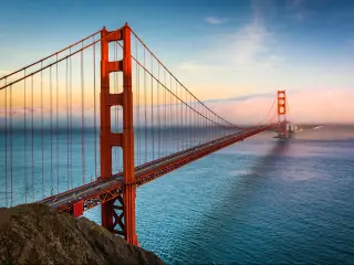
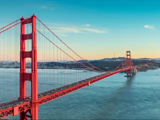
Point Reyes is just a short drive from San Francisco, crossing the Golden Gate Bridge to Marin County in Northern California.
The peninsula is historically famous as the point where Sir Francis Drake first landed in the Americas and stretches from Bolinas in the south to Bodegas Bay in the north.
There are a number of interesting sights in Point Reyes. The northern tip of the peninsula is home to a protected heard of Tule Elk - if you take the Tomales Trail, you should see plenty on your way up.
Then there's the recently restored Point Reyes Lighthouse. You have to climb 300 steps down a cliff face to get to the rock where it stands but it's worth it and the views of the waves crashing against the rocks are amazing.
On the way to the Lighthouse, stop at the Cypress Tree Tunnel - this stretch of road runs through an actual tunnel made out of trees merging above the road.
It looks far more like a driveway to a plantation in the deep south than something on the coast of Northern California and definitely worth a photo.

Sasha Yanshin – Co-Founder & Lead Driver
Sasha Yanshin has spent the last 15+ years mapping and driving thousands of miles across Europe and the US. As the Co-Founder and Lead Driver of Lazytrips, he brings an analytical approach to road-tripping, sharing meticulously tested routes, realistic drive times, and the hard-earned logistical reality of the open road.
Read full bio