Can You Drive To The Florida Keys?
Driving along Florida Keys is one of America's most iconic and scenic road trips. In answer to the question ‘can you drive to the Florida Keys?', the response is a resounding yes! Driving to the Keys from mainland USA is simple and you have the option of extending your trip all the way south to Key West.
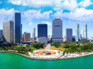
You can drive to the Florida Keys from mainland Florida in just over an hour. US-1 will take you from Miami to Everglades National Park, and on to Key Largo. From here, US-1 continues through the Florida Keys all the way to Key West.
Read on to find out how you can drive to the Florida Keys and along the archipelago to the southernmost city, Key West.
Is it possible to drive to the Florida Keys?
Driving to the Florida Keys is easy from the state of Florida which can be accessed by car from anywhere in the contiguous United States. The Florida Keys are an archipelago of 800 islands which stretch in an arch from the southern tip of Florida.
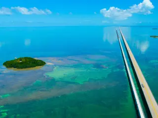
The main keys are connected by 42 bridges which form part of the Overseas Highway, a 125 mile long causeway which runs the length of the keys.
Driving from Florida state to the Florida Keys is as simple as starting the engine. You can travel from Miami to Key Largo in 1 hour and 10 minutes by heading south and crossing Florida's infamous Everglades before entering the island paradise at Key Largo.
You can then continue the journey along the keys from Key Largo to Key West, the southernmost key, in just 3 hours.
Alternatively, you can take a ferry from Marco Island or Fort Myers to Key West. Here is our ultimate guide for everything you need to know about making the ferry trip from Florida to Key West.
How to get to the Florida Keys from mainland Florida
From mainland Florida and Miami International Airport you can reach the Florida Keys by driving along the US 1 highway. The highway goes directly from Miami through the Everglades National Park to the most northerly key, Key Largo. If you want to avoid traffic on US 1, you can try the less trafficked FL 997 and Card Sound Rd to FL 905 in Key Largo.
From this point take the Overseas Highway which connects all the keys from the north to Key West at the very south.
From Miami take the US 1 highway down to the Florida Turnpike. Then go south to Exit 4 - Homestead/Key West. This is the Turnpike Extension that will connect you to Route US 1 in Florida City. The US 1 – known as the Overseas Highway takes you all the way to Key West.
The journey from Miami which is the closest city to Key Largo is 24 miles. From Key Largo to Key West it is a further 101 miles making the total journey from Miami to America's most southerly city 125 miles.
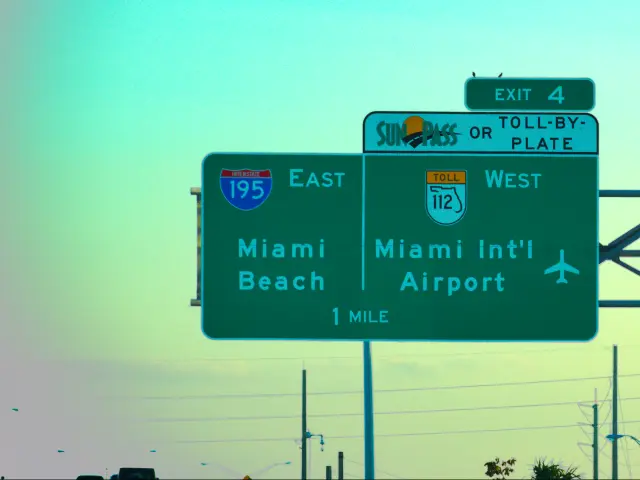
If you are coming from out of state then or abroad then the closest airport to the Florida Keys is Miami International Airport. The airport runs regular national and international flights throughout the year. A useful alternative is Fort Lauderdale which is quieter and easier to navigate.
How long does it take to get to the Florida Keys?
The journey from Miami, which is the closest large city to the Florida Keys, takes 1 hour and 10 minutes. From Fort Lauderdale which is slightly further north, it takes 1 hour and 40 minutes and from Tallahassee, which is the capital of Florida state, it takes 8 hours.
Driving the entire length of the Overseas Highway will take 4 hours with the bridges and roads from Key Largo to Key West taking the bulk of that time at 3 hours on the road.
Driving route from Florida to Key West
The Florida Keys consist of 800 keys which run in a south westerly arch from Key Largo. They main keys in this archipelago are Key Largo, Islamorada, Marathon, Big Pine and the Lower Keys, and Key West.
The 125-mile-long chain of islands are connected by 42 bridges which run over the Atlantic Ocean, Florida Bay and the Gulf of Mexico.
Highway 1, which connects the mainland to the keys, is also known as the Overseas Highway. It is renown as being one of the most beautiful drives in the world.

The majority of the Overseas Highway is two lane which makes its very prone to traffic, so bear this in mind during peak tourist season and time your travels to the next key accordingly. The highway is also very dark at night so be extra cautious travelling after dusk.
The Florida Keys Overseas Highway is marked at each mile by a green marker in descending in order from mile marker 113 at the Miami-Dade/Monroe County line to marker 0 in Key West. The markers are frequently used to denote points of interest and even mark an address. Keep an eye out for the mile markers as they are the best way to navigate the Florida Keys.
The Keys can be divided into three regions:
- Upper Keys: Stretching from Key Largo into Islamorada. These are the busiest keys as they are easily reached on a day trip or weekend break from Miami and nearby towns.
- Middle Keys: The 7-mile bridge denotes the Middle Keys separation from the Upper Keys.
Marathon is the largest key at 10 miles, and the largest city in the middle keys. These keys are much quieter and less populated that the more northerly keys.
Other notable keys in the middle are Vaca Key, Fat Deer Key and Grassy Key. The Middle Keys are famed for their fishing heritage and it's a great place to try some local crab and lobster.
Marathon is famous for the Seven Mile Bridge (actually 6.79 miles long), one of the longest segmental bridges in the world. - Lower Keys: the lower keys considerably quieter. A region of small islands is connected from the west end of the Seven Mile Bridge at Sunshine Key.
Key West is the largest city in the Lower Keys. An area typified by its natural beauty. The lower keys are home to wildlife refuges, a national marine sanctuary and a state park and are one of the best places to dive and snorkel in the States.
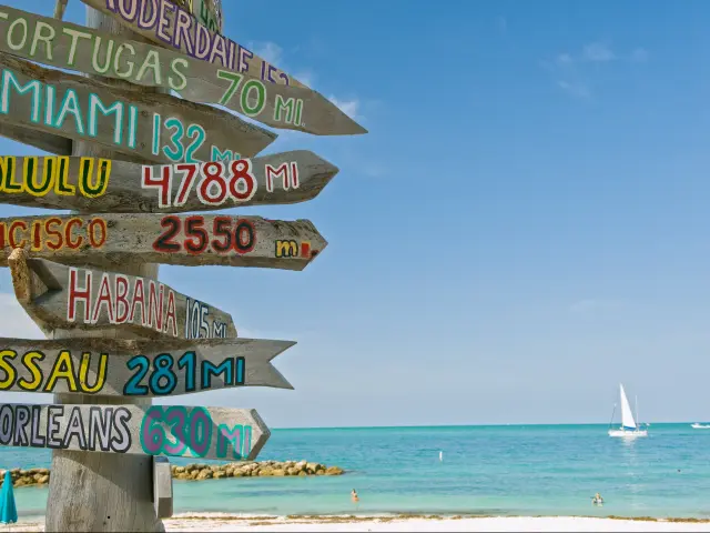
Key West is a 2-by-4-mile island and is home to the southernmost point in the continental United States. It lies only 90 miles north of Cuba.
Things you need to know about driving to the Florida Keys
If you are flying in to Florida state then Miami International Airport is the closest airport to the Florida Keys.
Many people prefer to fly into Fort Lauderdale. It's 30 minutes north of Miami, which adds on half an hour to the drive, but flights are often cheaper, queues are shorter and it's easier to manage than the colossus that is Miami.
The fastest route from Miami is along the US1 which goes from Miami all the way to Key West.
A quieter but less direct route is the FL 997 and Card Sound Rd to FL 905 in Key Largo.
As traffic can be a problem on the highway so can parking be a problem in the cities and towns. Key West parking can be particularly difficult, especially in Old Town. It's often easier to park out of town and catch a ride in.
Gas is the same price as the mainland from Key Largo to Marathon, but it rises by about 60 cents south of Marathon, including Key West. There are loads of gas stations on the keys, you will find one every 30 minutes or so.
The Florida Keys have a subtropical climate with warm temperatures all year round. When it rains it is usually a brief downpour followed by sun.

Sasha Yanshin – Co-Founder & Lead Driver
Sasha Yanshin has spent the last 15+ years mapping and driving thousands of miles across Europe and the US. As the Co-Founder and Lead Driver of Lazytrips, he brings an analytical approach to road-tripping, sharing meticulously tested routes, realistic drive times, and the hard-earned logistical reality of the open road.
Read full bio