16 Best Waterfalls in Yosemite National Park
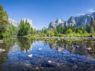
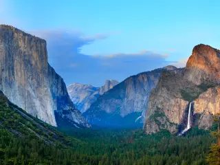
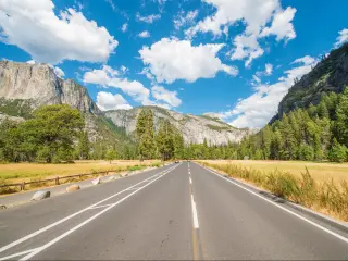
Yosemite National Park is located in California's Sierra Nevada Mountains. With its spectacular granite landscape and high density of mountain peaks and valleys, Yosemite is the perfect place to go hunting waterfalls - all that winter snowfall needs to find a way down the mountains somehow!
Yosemite Valley is at the heart of the national park, and it's where you'll find most of its waterfalls, including Yosemite Falls, Bridalveil Fall and Horsetail Fall. Other districts of the national park have some stunning waterfalls to discover too.
Some of the world's highest waterfalls are located inside the national park, but even the ones that are more moderately sized are a spectacular addition to the landscape. Some are visible from the road or via a short trail, while others will see you following exhilarating hikes through the unspoiled national park landscape to discover hidden gems.
| Waterfall | Description |
|---|---|
| 1. Yosemite Falls | The highest waterfall in North America, cascading in three distinct stages for a total drop of 2,425 feet |
| 2. Bridalveil Fall | One of the most recognizable sights, a 620-foot drop creating an ethereal mist that resembles a bride's veil |
| 3. Sentinel Fall | Flowing in multiple tiers for a total drop of 2,000 feet, best viewed in the spring |
| 4. Ribbon Falls | The tallest single-drop waterfall in North America with a stunning 1,612-foot freefall |
| 5. Horsetail Fall | Known for its "Firefall" effect in February, this waterfall appears to glow orange during sunset |
| 6. Vernal Fall | With a powerful 317-foot plunge, it's recognized for drenching hikers on the mist trail during spring |
| 7. Tueeulala Falls | A picturesque waterfall in the Hetch Hetchy Valley, most vibrant during the spring melt |
| 8. Wildcat Falls | Visible after rainfall, this lesser-known cascade is a tranquil spot along the Big Oak Flat Road |
| 9. Nevada Fall | A thunderous 594-foot waterfall, distinct for its unique, angular drop |
| 10. Illilouette Fall | Tucked within a granite alcove, this 370-foot waterfall nourishes the Merced River |
| 11. Wapama Falls | This multi-segmented 1,080-foot waterfall is a Hetch Hetchy Valley marvel |
| 12. Chilnualna Falls | A hidden treasure in Yosemite's south, cascading in various stages for a total of 690 feet |
| 13. Waterwheel Falls | Distinctive for its waterwheel effect, where water is thrown into the air due to the granite's shape and force |
| 14. Rancheria Falls | A peaceful cascade along Rancheria Creek, providing a serene backdrop for hikers |
| 15. Silver Apron Cascade | Nestled between Vernal and Nevada Falls, this smooth granite slope sees water gliding over it like a swift stream |
| 16. Carlon Falls | A secluded 35-foot drop that culminates into a serene pool, offering a peaceful escape |
Please see the map below to see where these waterfalls are located in Yosemite National Park:
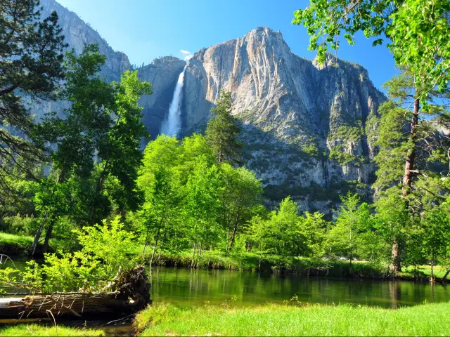
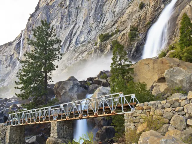
1. Yosemite Falls
Height: 2,425 feet
What makes this waterfall special: Yosemite Falls is the national park's highest waterfall and, by some measures, the highest in the whole of North America.
It's made up of three sections – Upper Yosemite Falls, the Middle Cascades and Lower Yosemite Falls.
In winter, a huge cone of ice builds up at the bottom of the Upper Falls, and on rare occasions in spring you might catch the unusual sight of a moonbow in the spray.
Best viewing spots: You can see Yosemite Falls from many parts of Yosemite Valley, including Sentinel Bridge and all around Sentinel Meadow.
In fact, Yosemite Falls is so huge that it can be seen from many vantage points further afield, including Glacier Point – the advantage of this is that you can drive up there and see Yosemite Falls from a high elevation without needing to hike.
The easiest way to see Yosemite Falls up close is to take the 1-mile hike, which starts near Yosemite Valley Lodge. This relatively accessible trail takes you to Lower Yosemite Falls.
The longer Yosemite Falls Trail takes you right to the top of the Upper Falls via a challenging 7.2-mile round-trip hike. Along the way you'll get plenty of chances to stop and look out across the falls, starting half a mile beyond Columbia Rock.
Closest entrance: Arch Rock Entrance is the closest but you can also get there easily from the South Entrance.
How to get there: From Arch Rock Entrance, take El Portal Road towards Yosemite Valley, then follow the one-way system along Southside Drive. Continue on the road as it loops around through Yosemite Village onto Northside Drive then you'll reach the parking area just after Yosemite Valley Lodge.
The trail to Columbia Rock and Upper Yosemite Falls starts just across from the parking area, near Camp 4.
Lower Yosemite Fall Trail also starts nearby, opposite the entrance to Yosemite Valley Lodge. Part of this trail is wheelchair accessible.
Best time to visit: Make an early start if you're hiking all the way to the top of Yosemite Falls as this strenuous walk is even harder in the midday heat.
Peak flow is April to June due to snow melt, but there's usually no flow at all by the end of summer unless a heavy rain storm passes overhead. That means, if you visit Yosemite in August or September, chances are you won't see the famous waterfall at all.
Flow resumes later in the fall due to rainfall, then continues through the winter.
Visit during the April or May full moon to see a moonbow – it's just like a rainbow, only made from the moonlight bouncing off the spray from the cascade.
Where to park: You can access both of the hiking trails from Yosemite Falls Parking Area. As you drive through Yosemite Valley, stop first at the Swinging Bridge parking area to see the view across the meadow.
Things to know: Yosemite Falls is accessible all year round, but Upper Yosemite Falls Trail is very popular and can get crowded so you might want to avoid visiting at weekends or during the peak summer season.
Upper Yosemite Falls Trail is also extremely strenuous and includes long, steep uphill sections right from the outset. Take care if you hike near the waterfall as surrounding rocks can get slippy.
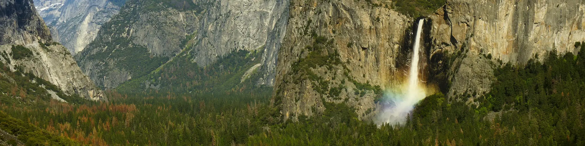
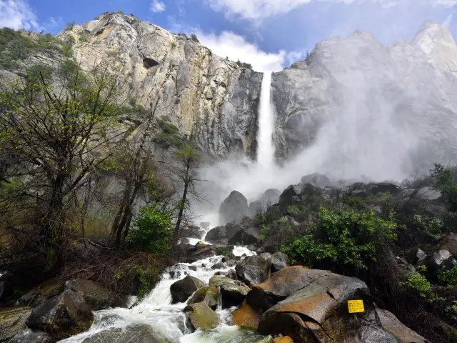
2. Bridalveil Fall
Height: 620 feet
What makes this waterfall special: Bridalveil Fall is located near the entrance to Yosemite Valley, so there's a high chance it will be your first introduction to Yosemite's many waterfalls.
When the wind catches the falling water it can blow quite a distance sideways, hence the reference to a bride's veil. Its native American name is Pohono – Spirit of the Puffing Wind.
Unlike many of the other waterfalls in the national park, it flows all year round, and has a different character depending on the season you visit.

Best viewing spots: Bridalveil Fall Trail is a manageable half-mile hike that takes you up close to the base of the waterfall.
You can also get a good view from Tunnel View as you approach Yosemite Valley.
Closest entrance: Arch Rock Entrance
How to get there: Follow El Portal Road from Arch Rock Entrance then cross Pohono Bridge to join Southside Drive. Turn right when you reach Wawona Road then stop at the signposted parking lot near the base of the falls.
Best time to visit: Bridalveil Fall is visible all year round but peak flow here is in the spring when the normally gentle cascade becomes much more pronounced.
Where to park: There's a parking lot close to the start of Bridalveil Fall Trail on Wawona Road. There's also parking on Highway 41/Wawona Road if you want to stop at Tunnel View too.
Things to know: Bridalveil Fall Trail is currently closed while preservation work is carried out on the trail.
3. Sentinel Fall
Height: 2,000 feet
What makes this waterfall special: Sentinel Fall works its way down the rockface in many stepped sections. It's almost as high as Yosemite Falls so if you catch it at the right time of year it's an impressive sight.
To the side of the Falls is Sentinel Rock, which adds to the drama of the landscape.
Best viewing spots: There are several places to stop and get a good look at Sentinel Fall. From the road, look up from Sentinel Beach Picnic Area or Four Mile Trailhead. From the opposite side of the valley floor, there's also a great view over Leidig Meadows on Northside Drive.
For an elevated view, keen hikers can see Sentinel Fall on Pohono Trail between Taft Point and Sentinel Rock. You can also see Sentinel Falls at a distance when you hike the Upper Yosemite Falls Trail.
How to get there from the closest entrance Follow El Portal Road and Southside Drive into Yosemite Valley then stop at Sentinel Beach or Four Mile Trailhead which are on either side of the road around half a mile before Sentinel Bridge.
Closest entrance: Arch Rock Entrance
How to get there: Follow El Portal Road and Southside Drive into Yosemite Valley then stop at Sentinel Beach or Four Mile Trailhead which are on either side of the road around half a mile before Sentinel Bridge.
Best time to visit: Sentinel Fall only flows in the spring – usually from March until around June - so there's not much waterfall action going on at other times of year.
Where to park: There's parking near Four Mile Trailhead and Sentinel Beach Picnic Area, close to the base of Sentinel Falls.
It's harder to stop at Leidig Meadows so park near Yosemite Falls instead and walk if you want to see this view properly.
Things to know: These falls are very seasonal so you won't see the cascade for much of the year. They're also dependent on snowmelt, so the best time to see them will vary with the conditions.
4. Ribbon Falls
Height: 1,612 feet
What makes this waterfall special: If you picture a waterfall as a sheer drop from a cliff top, then you're probably thinking of something that looks pretty much like Ribbon Falls.
The water here falls vertically down the rock face rather than cascading in steps or sections, so while it's nearly 1,000 feet short of being the highest waterfall in Yosemite, it's the longest free-leaping (vertical drop) waterfall (when it's flowing).

Best viewing spots: You can see Ribbon Fall from the road – simply pull over in the turnouts as you enter Yosemite Valley.
Ribbon Falls is also part of the landscape that you'll see at Valley View Lookout, further along your drive through Yosemite Valley.
Closest entrance: Arch Rock Entrance
How to get there: Take El Portal Road, then turn onto Southside Drive into Yosemite Valley. Just after the Bridalveil Fall Trailhead, pull over in one of the turnouts on Southside Drive to see the waterfall.
Best time to visit: Fed by snowmelt, Ribbon Falls only usually flows between March and June, but this can vary a little due to snow conditions.
Visit in the middle of the day for the best light – at other times of day, shadows mean this waterfall doesn't stand out as much, which is particularly important if you're trying to get a photograph from a distance.
Where to park: There's no specific parking lot for Ribbon Falls but there are places to pull over along Southside Drive as you travel through Yosemite Valley. There's also roadside parking along Northside Drive for Valley View Lookout.
Things to know: These waterfalls are accessible all year round as there's often little or no snow on the floor of Yosemite Valley, but for much of the year you'll just see a dry rock face.
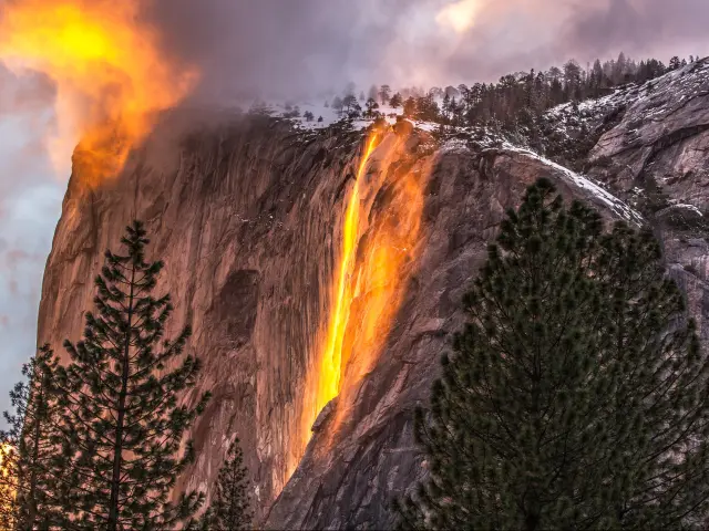
5. Horsetail Fall
Height: 1,000 feet
What makes this waterfall special: This is one of Yosemite's most famous sights. For a few evenings each year, it will look like a river of lava is falling down the cliff face. Known as Firefall, this unique phenomenon is caused by the setting sun reflecting off the water.
Best viewing spots: Aim for El Capitan Picnic Area to get a good angle of the Firefall phenomenon.
Closest entrance: Arch Rock Entrance
How to get there: From El Portal Road, follow the loop of Southside Drive through Yosemite Village and onto Northside Drive. Pass Yosemite Valley Lodge, then after just over a mile, park at El Capitan Picnic Area on the righthand side of the road.
Best time to visit: Firefall is visible for just a few evenings in February, usually in the second half of the month. Arrive ahead of the sunset to find yourself a parking space – and then wait.
If you're in Yosemite at other times, you can still see Horsetail Falls looking like a regular waterfall between December and April.
Where to park: You used to be able to pull up on Southside or Northside Drive to see the Firefall. Now that visitor numbers have increased massively, restrictions will be in place on Firefall evenings and you'll have to park near Yosemite Valley Lodge and walk the 1.5 miles along Northside Drive to Horsetail Fall.
If you're visiting at other times you can simply park at El Capitan Picnic Area on Northside Drive.
Things to know: Firefall is a popular sight so don't expect to have the view to yourself. Check ahead to find out about parking restrictions as these might change from year to year.
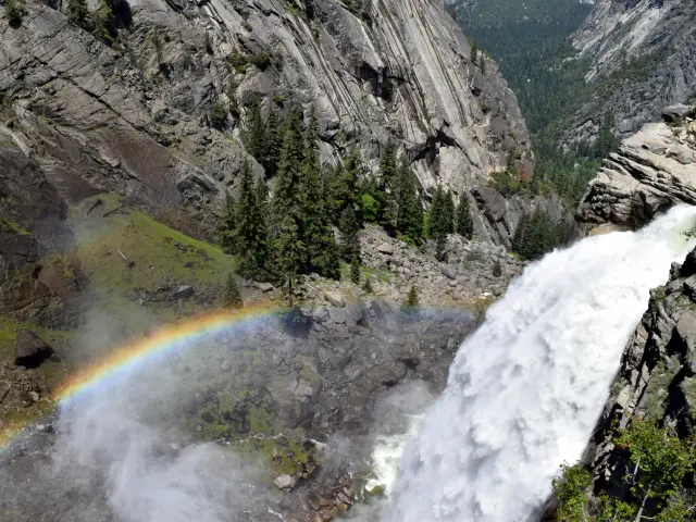
6. Vernal Fall
Height: 317 feet
What makes this waterfall special: Vernal Fall is a contrast to many of Yosemite's waterfalls, as it's (relatively) short and wide rather than tall and narrow.
Located at the far end of Yosemite Valley, this is one of the few waterfalls in Yosemite to be visible all year round so it's a great place for late summer visitors to come for a spectacular waterfall photo opportunity.
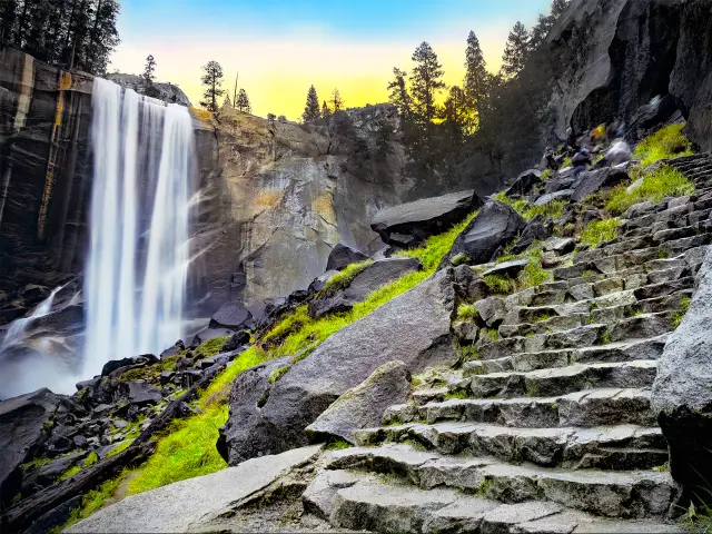
Best viewing spots: You'll need to hike to get a good look at Vernal Fall. Mist Trail takes you all the way to the top of the waterfall, with several viewing points along the way. You can stop partway at the Vernal Footbridge if you don't have time to complete the full hike.
Other great views are found at Lady Franklin Rock as you make your way along the Mist Trail. Or take the John Muir Trail to Clark Point for an impressive view down towards Vernal Fall.
For a less strenuous view, you can also see Vernal Fall from Glacier Point, which is much further away but is much more easily accessed from the road.
Closest entrance: Arch Rock Entrance
How to get there: From the entrance station, take El Portal Road then join Southside Drive close to Bridalveil Valls. When you reach Sentinel Bridge, turn right onto the Happy Isles Loop Road.
To reach the top of the waterfall, you'll have to follow the Mist Trail or the John Muir Trail, which both start out from Happy Isles Trailhead.
Best time to visit: You can appreciate the falls all year round, with peak flow usually seen in May.
The hike can be strenuous, so it's better to visit in late spring before Yosemite warms up too much – but be aware the path can also be closed in winter due to snow and falling ice.
Where to park: There's parking at Yosemite Valley Trailhead which is shortly before Happy Isles Art and Nature Center.
Things to know: It's harder to see Vernal Falls in the winter – the Mist Trail is often closed due to the conditions, as is the road up to Glacier Point.
As the name suggests, Mist Trail can get very wet. Dress for rain, even on a fine day, and protect your camera or other fragile equipment.
The final section of Mist Trail includes steep, narrow steps and a drop off that won't appeal to hikers with a fear of heights.
7. Tueeulala Falls
Height: 840 feet
What makes this waterfall special: This is one of two falls that cascade into Hetch Hetchy Reservoir, so it's one you'll want to head for if you're not just visiting Yosemite Valley on your trip. It has an impressive vertical drop – especially on days when there's a high flow.
Best viewing spots: Look out for a view from the O'Shaughnessy Dam when you arrive at Hetch Hetchy Reservoir. This will depend on flow conditions.
To get a closer look, follow the trail around the reservoir towards Wapama Falls, about a 4-hour round trip depending on how close you get to the top of the falls.
Closest entrance: Hetch Hetchy Entrance
How to get there: From the entrance station, follow Hetch Hetchy Road all the way to the reservoir, where you'll find a parking area. You can't park directly by the falls, instead you'll have to hike from the parking area.
Best time to visit: It can flow between March and June, but is notoriously variable.
Where to park: Half way round the loop at the end of Evergreen Road there's a parking area close to the dam. The trailhead starts from here.
Things to know: Hetch Hetchy Entrance and the road to the reservoir are only accessible during the daytime – check ahead as exact opening hours change throughout the year.
Occasionally the flow can become so intense that it floods the trail. Take care of hiking conditions if this is the case, as the trail can be very slippery.
8. Wildcat Falls
Height: 720 feet
What makes this waterfall special: It's not one of the most famous Yosemite waterfalls, so it's a good one to head to for a serene waterfall viewing experience.
Best viewing spots: You can see up to the top part of Wildcat Falls from El Portal Road, but seek out an unmarked trail by Wildcat Creek to get close to the base of the falls.
Closest entrance: Arch Rock Entrance
How to get there: Follow El Portal Road as it hugs the Merced River. After just a couple of miles you'll reach Cascades Picnic Area which is the best place to stop.
Best time to visit: Wildcat Falls flows through the spring but dries up from May or June onwards.
Where to park: Stop at the parking area for Cascade Falls on El Portal Road, from where it's a short walk to Wildcat Falls. You'll have a short walk along the highway to get here so avoid visiting in low light conditions.
Things to know: You'll have to look closely to spot Wildcat Falls – they're tucked away a little compared to other Yosemite waterfalls, and don't have their own parking area.
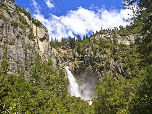
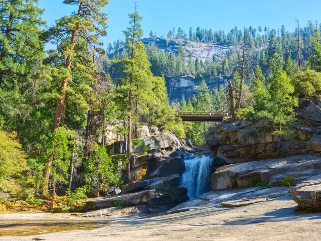
9. Nevada Fall
Height: 524 feet
What makes this waterfall special: This powerful waterfall flows all year round, so it's a good place to visit in late summer or fall if the other falls around Yosemite Valley have stopped.
If you're hiking to the top, you can tag on a visit to Vernal Falls and you'll pass some stunning sections of the Merced River too, including the Silver Apron and Emerald Pool, making this a scenic half-day hike.

Best viewing spots: John Muir Trail or Mist Trail will take you up to a footbridge at the top of Nevada Falls. It's great to look down from here as the water cascades over the rock face.
There are also many scenic views along the trail, including the one from Vernal Footbridge – near the top of Vernal Falls, you'll get a view through the forest to see the upper section of Nevada Fall.
If you're visiting Glacier Point, you also look out for Nevada Falls, which is visible from a distance as part of this stunning panorama.
Closest entrance: Arch Rock Entrance
How to get there: From Arch Rock Entrance, take El Portal Road to reach Yosemite Valley then follow Southside Drive for 6 miles to the turn with Happy Isles Loop Road. Use the Yosemite Valley Trailhead Parking on the Loop Road to see Nevada Fall from the trails.
If you're viewing Nevada Fall from Glacier Point, use the South Entrance and follow Wawona Road for 17 miles before turning onto Glacier Point Road.
Best time to visit: Nevada Fall flows all through the year but peak flow is in May with the snow melt. Trails are sometimes closed in the winter as huge icicles can fall when temperatures start to rise
It's best visited at cooler times of day if you're following the Mist Trail or John Muir Trail in summer, due to the strenuous hike.
Where to park: Park at Yosemite Valley Trailhead for access to Mist Trail or John Muir Trail. Alternatively, there's a parking area at the end of Glacier Point Road.
Things to know: If you're hiking up to Nevada Fall you'll pass Vernal Fall along the way so can combine the two.
The spray on Mist Trail can make paths slippery so take care when walking.
Glacier Point is only accessible when the road is open (usually May to November). During these months there's wheelchair access to the viewpoint.
10. Illilouette Fall
Height: 370 feet
What makes this waterfall special: This is one of the less-visited waterfalls in Yosemite, since you'll have to work a bit harder to get here.
It drops with some force down the granite rock face and the contrast between the grey rock and white water means that you can see it flowing away at the bottom of the sheer cliff face.
Best viewing spots: Illilouette Fall can't be seen from the road – you'll have to put your hiking boots on to see this one. Pick up Panorama Trail from Glacier Point Viewpoint for the closest view.
It's also visible in the distance from John Muir Trail on the way to Vernal Fall or Nevada Fall.
Closest entrance: South Entrance
How to get there: Take Wawona Road for 17 miles through the park then turn right onto Glacier Point Road and follow it to the end, where you'll find the viewpoint and parking. Join the Panorama Trail here for the 4-mile round trip to see the waterfall.
Best time to visit: Illilouette Fall flows all year round but for the best combination of road access and strength of the waterfall, visit in late May or early June. Glacier Point Road should be open by this time, but you'll still catch the impressive sight of the waterfall during peak snow melt.
The viewpoint at Glacier Point is a popular one so aim to get here early to be sure of a parking spot. Setting out at sunrise means you'll get a great view at Glacier Point before your hike – the light on the granite cliffs is perfect for photographing the view.
Where to park: There's parking at the end of Glacier Point Road.
Things to know: The trail off Glacier Point Road isn't accessible during the road's winter closure (usually November to May). Check before visiting in case reopening has been delayed due to the snow.
Panorama Trail is a fairly challenging 3-hour hike – you go steeply downhill at first, which means it's all uphill on the way back.
11. Wapama Falls
Height: 1,100 feet
What makes this waterfall special: This is one of Yosemite's few year-round waterfalls, cascading into Hetch Hetchy reservoir close to Tueeulula Falls. It's also the biggest waterfall in this part of the national park.
Best viewing spots: Wapama Falls is visible from O'Shaughnessy Dam at the end of Hetch Hetchy reservoir.
For a closer look, the Wapama Falls trail takes you to a series of footbridges near the base of the falls.
Closest entrance: Hetch Hetchy Entrance
How to get there: Follow Hetch Hetchy Road from the entrance station to where it ends by the dam. It's then a 2-hour round trip along Wapama Falls Trail to see it up close.
Best time to visit: It gets warmer in Hetch Hetchy than Yosemite Valley so plan accordingly if visiting in the summer. Avoid hiking at midday as there's no shade on Wapama Falls Trail.
Where to park: Park by O'Shaughnessy Dam on Evergreen Road.
Things to know: These falls are accessible all year round but Hetch Hetchy Entrance isn't open 24 hours a day so check ahead for opening times – you won't be able to drive to the reservoir if the entrance station is closed.
12. Chilnualna Falls
Height: 2,200 feet
What makes this waterfall special: This is actually a series of waterfalls that makes a chain down the rocks. It's located in Wawona, so it's not on Yosemite Valley's main waterfall viewing circuit, and it can be a much more peaceful experience as long as you're prepared to hike to see the falls.
Rather than one impressive cascade, you'll be able to see waterfalls taking different routes through the rocks, making this a varied but strenuous experience.

Best viewing spots: Chilnualna Falls isn't visible from the road. To get all the way to the top it's a challenging 7-hour round trip hike but as you walk you'll be rewarded with regular views of Chilnualna Creek and smaller waterfalls.
Closest entrance: South Entrance
How to get there: Follow Wawona Road then turn right after a couple of miles onto Chilnualna Road. This takes you through the village of Wawona then at the end of the road you'll find a parking area and the start of the trailhead.
Best time to visit: The waterfall flows all year round with peak flow during the late spring snowmelt. The walk also takes you through sections of meadow where wildflowers add extra color in late spring.
It's a long hike so don't start out too late in the day – it's best to set off in the morning so you've done the uphill section before it gets hot.
Where to park: At the end of Chilnualna Road there's a parking area close to the trailhead which leads up to the falls.
Things to know: The waterfall flows all year round but hike with the conditions in mind, if at all, when there's snow or ice on the ground.
13. Waterwheel Falls
What makes this waterfall special: This unusual waterfall actually sees water flying up rather than down in places, which is how it gets its name.
The shape of the rocks throws cascading water up to 30 feet into the air, and then it's blown backwards by the wind, creating the waterwheel effect.
On the trail to the falls, you'll also pass a series of other stunning waterfalls.

Best viewing spots: To see the waterwheel is a serious undertaking – it's a 16-mile round trip which will take most 12 to 14 hours to complete.
Closest entrance: Tioga Pass Entrance
How to get there: From the entrance station, follow Tioga Road for around 8 miles until you reach Tuolumne Meadows Visitor Center. From here you'll have to go the rest of the way on foot.
Best time to visit: The waterfall flows all year round but visit in May or June, when the flow is strongest, for the best chance of seeing the waterwheel phenomenon. Tioga Road is closed from November to May so you won't be able to visit during the winter.
Arrive early to be sure of a parking space at the popular Tuolumne Meadows. This also gives you plenty of time for the hike itself.
Where to park: Park at Tuolumne Meadows Visitor Center or in one of the turnouts along Tioga Road if you can find a space closer to the trailhead.
Things to know: This is a long and fairly challenging hike and not suitable for beginners.
14. Rancheria Falls
What makes this waterfall special: This is a beautiful place to head to on a hike through the Hetch Hetchy part of Yosemite. It's possible to swim in places, which will be a welcome relief on a long hike, though always use your own judgment around safety before getting in the water.
The waterfall itself isn't as spectacular as others in Yosemite, but as the focal point of the trail, it's a great day out for keen hikers. The hike to Rancheria Falls starts out on Wapama Trail so you'll also see Tueeulala Falls and Wapama Falls on the way.

Best viewing spots: Follow the trail to the top of Rancheria Falls (a 14-mile round trip)
Closest entrance: Hetch Hetchy Entrance
How to get there: Follow Hetch Hetchy Road from the park entrance to O'Shaughnessy Dam then pick up the trailhead from the parking area. Start out on Wapama Trail then continue to follow the trail which runs parallel to the northern shore of Hetch Hetchy Reservoir.
Best time to visit: Set out early in the day as this is a long hike and you'll need time to get back to the parking area.
Hetch Hetchy only opens during daylight hours so it's not possible to completely avoid the hottest part of the day on the hike to the waterfall.
Where to park: There's a parking area at the end of Hetch Hetchy Road, right by the dam.
Things to know: This is a long hike through a notoriously warm and unshaded part of Yosemite. It also includes significant and sometimes steep up hill sections. Be prepared for hiking in these conditions and make sure you carry enough water and food for the day.
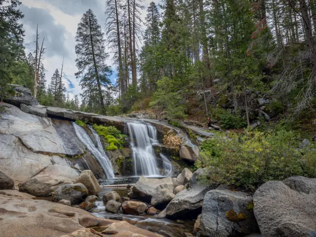
15. Silver Apron Cascade
What makes this waterfall special: While not a waterfall in its own right, this is a stunning section of the Merced River that you'll pass on the John Muir Trail if you're visiting Nevada Fall or Vernal Fall.
The Silver Apron acts as a kind of water slide, with swimmers in the past riding down the slippery granite and then enjoying the fresh water in Emerald Pool.
However, after a number of fatalities and near-misses, swimming is now prohibited here, so don't hike up there expecting to enjoy a refreshing dip.
Best viewing spots: Silver Apron can be viewed from the John Muir Trail
Closest entrance: Arch Rock Entrance
How to get there: El Portal Road leads you on to Southside Drive. Then turn right onto Happy Isles Loop Road and follow it to Yosemite Valley Trailhead.
Best time to visit: In late spring the Merced River will be at peak flow following snow melt, making for some spectacular scenes.
Where to park: Stop at Yosemite Valley Trailhead on Happy Isles Loop.
Things to know: As already mentioned, swimming here is dangerous and prohibited, however inviting the water looks.
16. Carlon Falls
Height: 35 feet
What makes this waterfall special: Carlon Falls is very modest in height compared to other Yosemite giants - in fact, the drop at Yosemite Falls is nearly 70 times the height of what you'll see at Carlon Falls.
However, the wide cliff that it drops off makes it feel different from other parts of Yosemite. It flows all year round, including through the summer months, and it's possible to swim here.
Best viewing spots: Follow Carlon Falls Trail to the waterfall.
Closest entrance: Carlon Falls Trail starts outside Yosemite in Stanislaus National Forest so you'll actually cross into the national park on foot.
How to get there: If you're starting inside Yosemite, leave via Big Oak Flat Entrance then head north for a couple of minutes on Big Oak Flat Road. Turn right onto Evergreen Road, which carries on to Hetch Hetchy Entrance after it passes Carlon Day Use Area, where you'll stop.
Best time to visit: This waterfall flows all year but unlike others in the park, the best time to see Carlon Falls is between June and August, so it's a great option if you're planning a summer trip to Yosemite.
For the best photos, come in the early afternoon in between the harsh morning light and the late afternoon shadows.
Where to park: Where Evergreen Road crosses South Fork Tuolumne River, there's a small turnout where you can park to access the trailhead. Alternatively park at Lower or Upper Carlon Picnic areas which are nearby.
Things to know: This trail is accessible all year round but hike with the conditions in mind during winter or the height of summer.
It's a relatively short and simple hike – around 4 miles. However, the trail isn't well marked so it's not ideal if you're looking for a straightforward hike.

Sasha Yanshin – Co-Founder & Lead Driver
Sasha Yanshin has spent the last 15+ years mapping and driving thousands of miles across Europe and the US. As the Co-Founder and Lead Driver of Lazytrips, he brings an analytical approach to road-tripping, sharing meticulously tested routes, realistic drive times, and the hard-earned logistical reality of the open road.
Read full bio