Can you drive through Death Valley?
The stunning landscape of Death Valley is part of the Mojave Desert, located mostly in Eastern California. It's a place of extremes - it's one of the hottest places on the planet and also features the lowest elevation point in the United States, 282 feet below sea level.
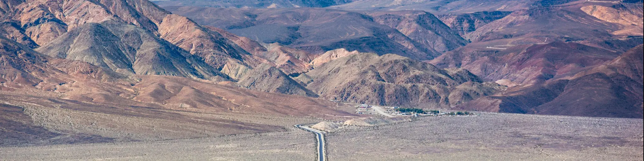
Large parts of Death Valley are inaccessible unless you're an experienced back country driver. However, you can drive on paved roads through Death Valley from Beatty, NV, to Saline Valley Road or head from Las Vegas to Death Valley Junction before exiting the national park at Panamint Valley Road.
There are many spectacular natural wonders to see in Death Valley, as well as hiking trails and camping grounds. Read on to find out what you need to know about driving through this unforgettable desert landscape.
Can you drive through Death Valley?
| Entrance | Exit | Distance | Crossing Time |
|---|---|---|---|
| Death Valley Junction | Saline Valley Alternate Road | 100 miles | 1 hour 50 minutes |
| Ridgecrest | Panamint Valley Road | 65 miles | 1 hour 15 minutes |
There are both paved and unpaved roads leading through Death Valley National Park, but we recommend taking the paved roads if you're driving straight through. This makes it possible to drive right through Death Valley, taking in some unforgettable vistas along the way.
As one of the hottest places on earth, Death Valley is usually considered to be a place to avoid during the summer months (from May to September).
At this time of year temperatures often reach 120 degrees Fahrenheit which makes hiking uncomfortable and often dangerous - even stepping out of your vehicle to enjoy the view can feel excessively hot.
Both Las Vegas and Beatty, NV, are good departure points if you're heading to Death Valley. Depending on the route you take it will take anywhere between 1 hour and 15 minutes to almost 2 hours to drive straight through the national park.

Click here to learn more about how to drive through Death Valley from Las Vegas.
Once you've reached Death Valley, the longer route from Las Vegas is a little more straightforward to navigate. However, it takes less time to drive through Death Valley if you set out from Beatty.
Whichever route you choose, you'll need to be prepared for the drive. You can't replenish water or fuel along the way, and there is often no cell phone service, so if you encounter difficulties rescue can sometimes be severely delayed.
As you'll be crossing such an extreme landscape always check for updates on the condition of roads on your chosen route using the National Park Service website, especially as there is ongoing damage from catastrophic flooding in the summer of 2022.
How to drive through Death Valley from Las Vegas
Leave Las Vegas via I-95 N then turn NV-373 which takes you south into California. It will take 1 hour 35 minutes to reach Death Valley Junction, where you'll enter the national park.
From Death Valley Junction, the 100-mile drive through Death Valley is under two hours long so it can easily be completed as a day trip. It follows CA-190 all the way so it's pretty simple to navigate.
This is a major road and it is paved and does not experience many closures as it is one of the more well-maintained roads through the national park.
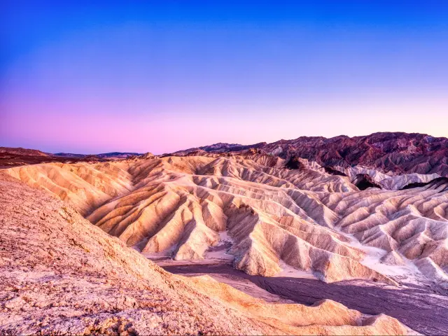
Along the way you'll pass Mount Perry, Funeral Mountain Wilderness Area, Zabriski Point and Furnace Creek.
From Beatty Junction our two recommended routes join up, and you'll pass the Devil's Cornfield, Stove Pipe Wells, Mesquite Flat Sand Dunes and Father Crowley Overlook before exiting the national park to the west.
How to drive through Death Valley from Beatty
Follow NV-374 south from Beatty and after just a couple of miles you'll pass the Welcome to Death Valley sign.
Crossing into California, the road becomes Daylight Pass Road, which you'll follow for a couple of miles before turning onto Beatty Road, which takes you as far as Beatty Junction. Here the route from Beatty joins up with the route from Las Vegas and you can follow CA-190 all the way to the park exit at Panamint Valley Road.
If you are tight on time, this is the route for you. It has more twists and turns than the route from Las Vegas, but it takes 35 minutes less to cross Death Valley on this route.
Along the way you'll be able to see Stovepipe Wells, Mosaic Canyon, Mesquite Flat Sand Dunes and Father Crowley Overlook.
Death Valley is also a really popular road trip destination for travellers coming from further afield, so see the table below for driving times and distances from other cities across the region.
| Origin City | Entry Point | Distance | Time |
|---|---|---|---|
| Sacramento | Saline Valley Alternate Road | 370 miles | 6 hours 30 minutes |
| Las Vegas | Death Valley Junction | 210 miles | 3 hours 30 minutes |
| Los Angeles | Panamint Valley Road | 220 miles | 3 hours 30 minutes |
| Reno | Ridgecrest | 330 miles | 5 hours 20 minutes |
| San Diego | Death Valley Junction | 320 miles | 6 hours |
| Phoenix | Death Valley Junction | 380 miles | 6 hours 30 minutes |
| San Francisco | Ridgecrest | 580 miles | 9 hours 40 minutes |
How long does it take to drive through Death Valley?
The time it will take you to drive through Death Valley depends on which route you decide to take.
If you're starting your trip in Las Vegas and entering at Death Valley Junction, you'll have to drive further through Death Valley so expect to spend at least 1 hour 50 minutes on the road.
Because of the shape of the National Park it's a shorter distance to cross Death Valley from north east to south west. This means that driving from Beatty will only take around 1 hour 15 minutes.
Whichever route you take, if you're planning on stopping to hike or admire the views then you'll need to add on extra time accordingly. And due to the extreme conditions that you might sometimes encounter, make sure you have enough water, snacks and fuel on board for a longer journey.
Which entrances should you use to drive through Death Valley
As we've already suggested, you can enter the eastern side of Death Valley via Beatty on SR-374 or Death Valley Junction on CA-190. These are two of the main routes into and across the national park.
There's also the option to enter the park from Shoshone and travel along CA-178 which joins up with CA-190 at Furnace Creek.
The routes we've suggested exit Death Valley to the west. If you're taking this trip in reverse, you can either enter via CA-190 heading towards Olancha, leaving the park at the junction with Saline Valley Alternate Road.
There's also the option to enter the park from another part of CA-178 which connects to the Panamint Valley Road entrance.
The main reason for choosing one entrance over any of the others is how well it suits your starting point, and how long a drive you'd like through Death Valley.
Things you need to know about driving through Death Valley
As we've already mentioned, you should be prepared for extreme conditions when you drive through Death Valley. The intense heat and potential for flash flooding shouldn't be overlooked when you're taking this trip. The National Park Service website makes it clear you should “travel prepared to survive”.
Here are our top tips when it comes to preparing for a drive through Death Valley:
- It costs $30 for up to 4 adults to enter Death Valley National Park in a car. This is payable online before your trip, or at the Furnace Creek Visitor Center.
- The drive through Death Valley is relatively straightforward if you stick to major, paved roads.
- Pack lots of water and food even if you're just planning a day trip, in case you get stuck and have to wait to be rescued.
- Travel in a car equipped with AC if possible.
- Make sure you have a full tank of gas, bring extra just in case.
- Stay alert while driving, and be ready to react to other drivers. There's also a chance of loose rocks falling on to the road.
- There's little to no cell service in Death Valley so to aid navigation carry a paper map or download the NPS app, which has an offline setting.
- As well as having extras like a first aid kit, spare tire and tools, make sure you know how to use them without looking up a video online.
- It rarely rains in Death Valley, but in 2022 a sudden and heavy storm caused significant damage to some roads and services in the park.
- Before you travel, you can check any ongoing road closures on the National Park Service website, which has an alerts and conditions page updated daily.
Things to see on a drive through Death Valley
The drive through the unforgettable landscape of Death Valley is an experience in itself, but if you want to spend a little longer exploring the national park there are some amazing natural attractions and viewpoints that you can visit.
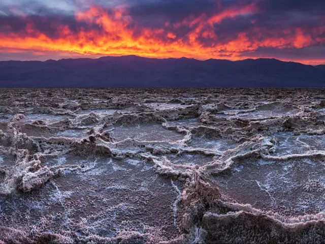
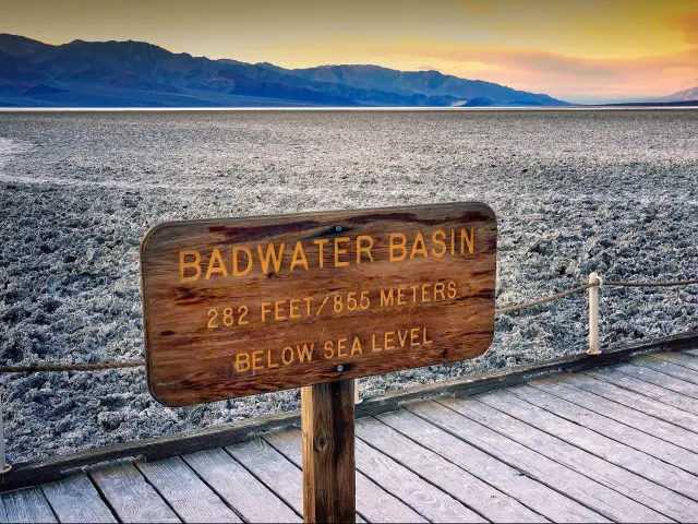
- Badwater Basin - At 282 feet below sea level, this popular site in Death Valley is the lowest elevation point in the United States. The salt flats that you'll see here are a really unique landscape.
- Dante's View - This viewpoint, up at 5,575 feet above sea level, offers an amazing overlook across Badwater Basin. It's a popular place to come to watch the sun rise or set.
- Artist's Palette - Follow the Artists Drive Scenic Loop to see colorful, naturally-formed rock formations
- Golden Canyon - Just off Badwater Road, you can follow a number of hiking trails from Golden Canyon, including one up to the stunning Red Cathedral rock formation.
- Mesquite Flat Sand Dunes - You can hike from Stovepipe Wells village to these huge dunes, which are home to sidewinder rattlesnakes and kangaroo rats.
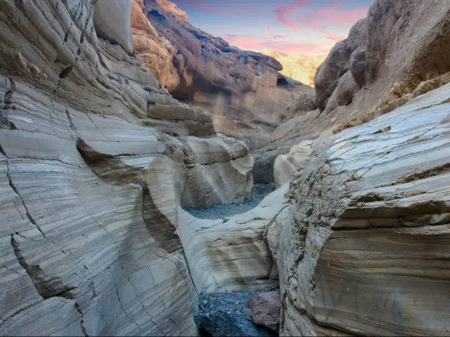
- Mosaic Canyon - For a more challenging hike, follow the unpaved road a short distance out of Stovepipe Wells then enjoy this wilderness walk through stunning rock canyons.
Whether you're planning on driving straight through or stopping to hike and admire this unique natural destination, a road trip to Death Valley is sure to be one to write home about.

Sasha Yanshin – Founder & Lead Driver
Sasha Yanshin has spent the last 15+ years mapping and driving thousands of miles across Europe and the US. As the Founder and Lead Driver of Lazytrips, he brings an analytical approach to road-tripping, sharing meticulously tested routes, realistic drive times, and the hard-earned logistical reality of the open road.
Read full bio