The Best Death Valley Photo Spots: Our Complete Guide (with map!)
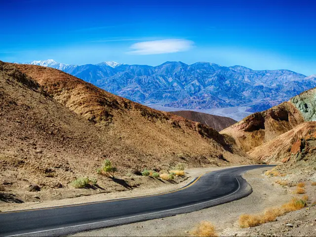
Close to California's state border with Nevada you'll find the unforgettable Death Valley National Park. Its 3 million acres are packed with stunning places to explore, and it holds the crown as the driest, hottest and lowest altitude national park in the United States.
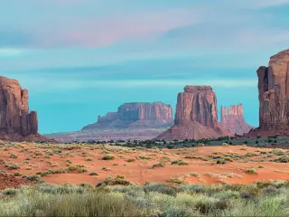
Located 90 minutes from Las Vegas, Death Valley National Park is a stunning destination for photographers. Its endless unique photo opportunities include Zabriskie Point, Racetrack Playa, Golden Canyon and the unforgettable Badwater Basin Salt Flats.
With its many distinct landscapes, including canyons and salt flats, Death Valley is the perfect place to travel with your camera. We've put together all the information you need to visit thirteen of the most impressive photo opportunities, so keep on reading to start planning your visit.
| Photo Spot | Nearest Entrance | Description |
|---|---|---|
| Zabriskie Point | Death Valley Junction | A panoramic viewpoint known for its vibrantly colored badlands |
| Racetrack Playa | Beatty | A dry lakebed famous for its "moving rocks" |
| Badwater Basin Salt Flats | Death Valley Junction | This surreal, flat landscape is covered with a thick crust of white salt |
| Artists Palette | Death Valley Junction | A geologic formation noted for a variety of rock colors |
| Natural Bridge Canyon | Death Valley Junction | Features a natural rock bridge located within a small, rugged canyon |
| Dante's View | Death Valley Junction | Provides a breathtaking panoramic view of Death Valley |
| Mesquite Flat Sand Dunes | Beatty | Views of beautiful lines and curves, especially during sunrise and sunset |
| Devil's Golf Course | Death Valley Junction | An extensive salt pan characterized by jagged spires of rock salt |
| Mosaic Canyon | Beatty | A beautiful canyon made of smooth, water-polished marble |
| Golden Canyon | Death Valley Junction | Popular hiking area is filled with golden-colored, eroded hills and cliffs |
| Devil's Cornfield | Beatty | Not a cornfield but a field of arrowweed plants with eerie, surreal appearance |
| Darwin Falls | West entrance | A lush oasis in the midst of the arid desert |
| Ubehebe Crater | Beatty | The crater's rim offers sweeping views of the multi-hued volcanic landscape |
Below, you can see the best photo stops on the map we have created. If you would like to learn more about driving though Death Valley National Park, check out our comprehensive guide.
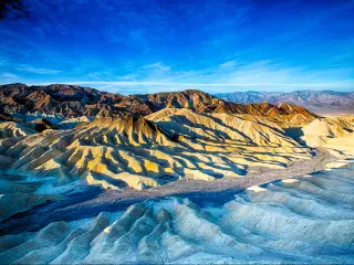
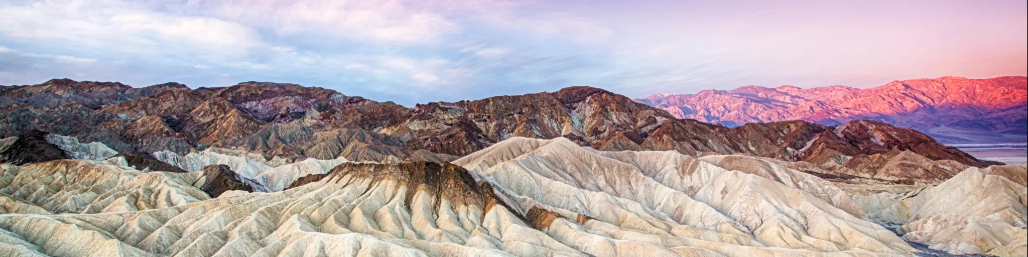
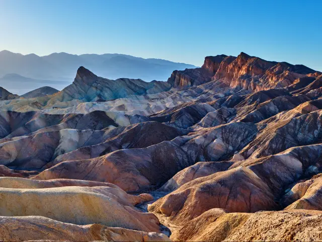
1. Zabriskie Point
What makes this photo spot special: You might have seen the landscape at Zabriskie Point before, since the scenery here was the backdrop for U2's Joshua Tree album cover. There's also a 1970 film called Zabriskie Point.
While it's known as a backdrop in modern culture, this scenic spot has been in the making for much longer. Its rolling hills are actually part of a landscape created by erosion from a dried-up 5-million-year lake.
How to get there: First, head to Death Valley Junction, which is on the eastern edge of Death Valley National Park around 90 minutes out of Las Vegas.
From here drive West on CA-190 for around 25 miles, then turn left into the Zabriskie Point car park. Once you've parked up, there's a trailhead to take you to Zabriskie Point.
Best time to visit: Zabriskie Point is a popular spot to take photos at sunrise and sunset. It's busiest at sunset because of the dramatic change in color.
Where to park: Zabriskie Point has its own parking lot on CA-190, which is clearly signposted in both directions.
2. Racetrack Playa
What makes this photo spot special: Racetrack Playa is famous for its mysterious moving rocks, which leave long trails behind them on the 3-mile-long dry lake bed that forms the playa.
There have been countless theories put forward about how they move, but scientists now think that it's the unique Death Valley climate and environment that helps to nudge these massive rocks forward.
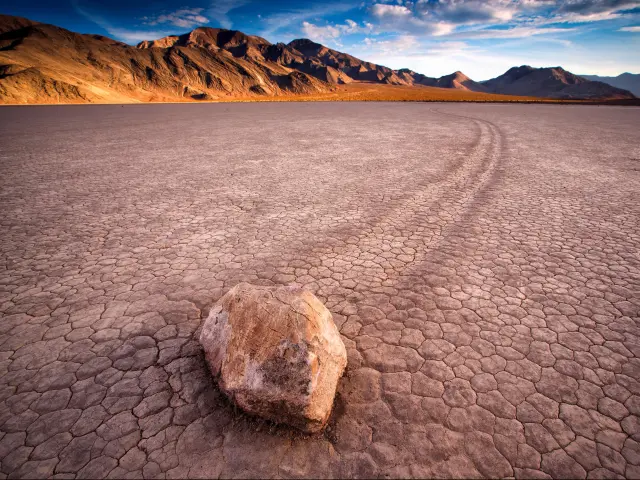
How to get there: From Beatty, NV, drive into California on the NV-374S which will continue onto Daylight Pass Road. About 30 minutes from Beatty, turn right onto Scotty's Castle Road, then left onto Ubehebe Crater Road. Finally turn right onto the unpaved Racetrack Valley Road and keep going for .
You should only attempt to visit Racetrack Playa with an appropriate vehicle, ideally a 4x4 with high clearance and heavy-duty tires to tackle the unpaved roads.
Best time to visit: Arrive early in the day - before 10AM - so you can have the space to yourself and take the best shots.
Where to park: There's a parking lot at the Grandstand - which also offers some stunning views - but you'll need to travel another two miles south to another, smaller parking lot to see the moving rocks.
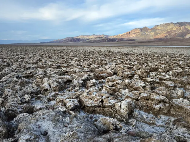
3. Badwater Basin Salt Flats
What makes this photo spot special: The white landscape here creates a distinctive photo opportunity. The salt flats are comprised mostly of sodium chloride, more commonly known as table salt, which is what gives the landscape its name.
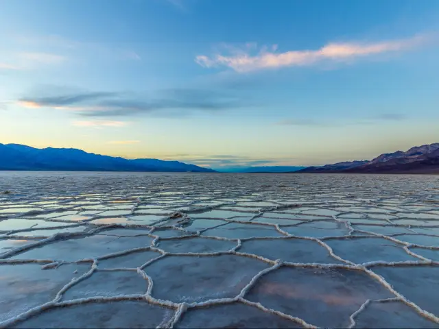
At 282 feet below sea level, you'll also find the lowest spot in North America here at Badwater Basin Salt Flats.
How to get there: From Death Valley Junction, drive on CA-190 W. After entering the national park you'll reach the Furnace Creek Inn, where you should turn left onto Badwater Road.
As you approach the salt flats, the white landscape is difficult to miss, but you'll also pass signs saying 'Welcome to Badwater Basin'.
Best time to visit: Sunrise and sunset are popular times to visit. However, because of the vast size of the salt flats, chances are that whatever time you visit you'll find a spot for a photo with no one in the background.
Because of the lack of shade and intense heat here, we'd recommend avoiding the summer months. If you do travel at this time of year, aim to get here early or late in the day.
Where to park: There's a parking lot just off Badwater Road that overlooks the striking white salt flats.
4. Artists Palette
What makes this photo spot special: There are vibrant and varied colors on the side of the mountains at Artists Palette, making for a stunning outlook and of course, a beautiful photo. The rainbow effects are actually created by volcanic deposits.
How to get there: From Death Valley Junction head towards the park entrance until you reach Furnace Creek Inn. Turn left here onto Badwater Road, then left again onto Artists Drive. You'll reach Artists Palette just under an hour after setting off from Death Valley Junction.
Best time to visit: In late afternoon and early evening the sunlight bounces off the rocks at Artists Palette, creating a magical visual effect.
Where to park: There's a small parking lot off Artists Drive right at the end of Artists Palette.
5. Natural Bridge Canyon
What makes this photo spot special: This spectacular natural landmark, which stands 35 feet tall and spans a stunning canyon, is really impressive to see and photograph.
There are several of these natural bridges in Death Valley National Park but this one is probably the most visited because it's accessible via a marked trail which follows the canyon.
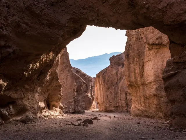
How to get there: Enter the park on CA-190 W from Death Valley Junction then turn left onto Badwater Road. Turn left at the signpost to drive the final mile and a half along the dirt road to Natural Bridge trailhead.
Best time to visit: You'll need to take at least a 1-mile round trip hike to see the natural bridge itself, so don't attempt to see this landmark after 10AM due to the heat.
As this is one of the more accessible trails and landmarks in the national park, Natural Bridge Canyon can get busy. If you're coming here just for the photo opportunity try to travel outside of weekends and holidays, or start early in the day before the crowds build up.
Where to park: It's possible to park at the start of the trailhead on a dirt road off Badwater Road.
6. Dante's View
What makes this photo spot special: Dante's View is a super-scenic spot on top of the Black Mountains. It's considered one of Death Valley National Park's top photography spots because of the panoramic view that you get at this high elevation.
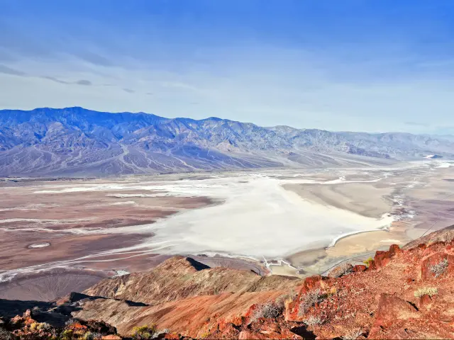
How to get there: Enter the park from Death Valley Junction then turn left onto Furnace Creek Wash Road and continue for around 8 miles. Furnace Creek Wash Road turns into Dante's View Road, continue driving until the viewpoint.
Best time to visit: Sunrise is a popular time for photographs here, and as with many parts of Death Valley you can get lucky with a look out over the absolutely stunning, colorful skies as the sun comes up.
Because you can drive right up to the view, you're less restricted on times at Dante's View, as long as you've got air conditioning. If you're here in winter, be aware that temperatures can also plummet at this higher elevation, so drive cautiously if you hit icy conditions. There's also a chance of snow closures.
Where to park: There's a large paved car park with fantastic views at the end of Dante's View Road.
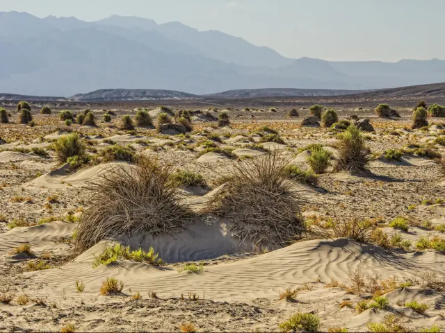
7. Mesquite Flat Sand Dunes
What makes this photo spot special: The sand dunes here offer another unique landscape that's great for photography. The eroding mountains to the north create sand, while the southern mountains trap it, resulting in large dune fields.
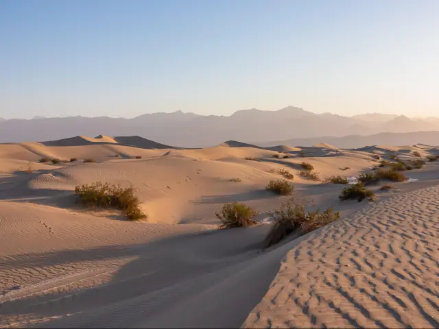
Add on the wind that races across exposed parts of Death Valley National Park and you'll see a stunning ripple effect all across the dunes that makes for memorable and creative photos.
How to get there: From Beatty, NV, enter the park on NV-374 S and continue on Daylight Pass Road. Turn left onto Scotty's Castle Road then turn right around a mile later to join CA-190 W. You'll soon reach the parking lot for Mesquite Flat Sand Dunes, which is on the right hand side of the road.
Best time to visit: The light at sunrise and sunset creates dramatic shadows. However, seeing as there's no official trail out to the dunes you'll need to be careful of burrows - take a flashlight or avoid starting the walk in complete darkness.
Where to park: Just off CA-190 there's a large, paved parking lot. Turn into it when you see the sign to the sand dunes.
8. Devil's Golf Course
What makes this photo spot special: The rough, jagged terrain of the Devil's Golf Course offers unique photo opportunities. As water evaporates here, stalagmites are created, so the landscape is dotted with spikey heaps.
How to get there: Enter the national park via Death Valley Junction and follow CA-190 W until Furnace Creek Inn, then turn left onto Badwater Road. After a few more miles, turn right onto Salt Pool Road where you see the sign post signalling Devil's Golf Course.
Best time to visit: The terrain is difficult to walk on, but you can get a great view from the parking lot or from the road. Since you won't be hiking far from here, this makes Devil's Golf Course accessible throughout the day, as long as you're following advice on safe travel through other parts of Death Valley National Park.
Where to park: There's a large unpaved lot at the end of Salt Pool Road.
9. Mosaic Canyon
What makes this photo spot special: The Mosaic Canyon trailhead takes you on an exploration to discover slot canyons. You'll find slot canyons in many parts of Death Valley National Park, but this is one of the most accessible.
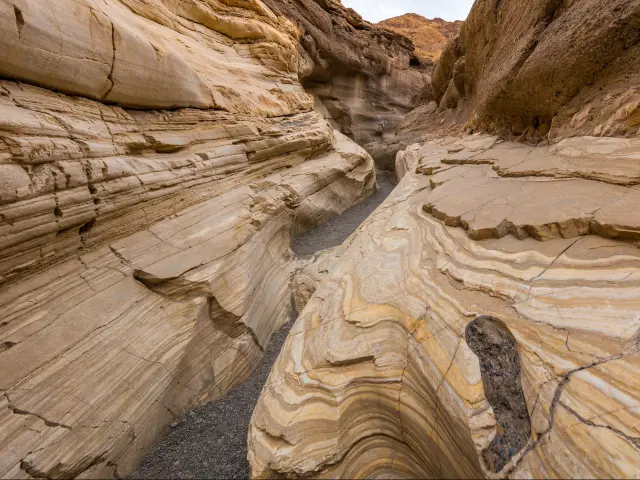
The narrow passageways and distinct mosaic-like rocks offer distinct photo opportunities, although the depth of the narrow canyon means that you'll probably be working in shady conditions.
How to get there: Enter Death Valley National Park via Beatty and continue on Daylight Pass Road. Turn left onto Scotty's Castle Road then right shortly after onto CA-190 W.
After Stovepipe Wells, take the dirt road on the left, marked as Mosaic Canyon Road.
Best time to visit: You'll have to walk the Mosaic Canyon Trailhead for the best photos, so avoid the heat. Don't head out after 10 AM and avoid the summer months.
Where to park: There's a parking lot nearby at the end of Mosaic Canyon Road.
10. Golden Canyon
What makes this photo spot special: The narrow passageways and rocky corridors of this beautiful canyon run through striking, golden-colored hills. The gold sandstone serves as a striking photo opportunity.

How to get there: Enter the park on CA-190 W from Death Valley Junction then follow Badwater Road after Furnace Creek Inn. When you reach the signpost for Golden Canyon, turn left.
Best time to visit: The time shortly after sunrise, when the sun creates a glow on the canyon walls, has become known as Golden Hour at Golden Canyon. This is a popular time to take stunning photos.
Where to park: The Golden Canyon Parking Lot is a paved parking lot just off Badwater Road. It can get busy since it serves as the hub for many trailheads.
11. Devil's Cornfield
What makes this photo spot special: The Devil's Cornfield is a vast, open space where shrubs sprout from the harsh desert terrain. The tall shrubs grow in a narrow shape similar to bundled up sheaves of corn, which is how this impressive natural landmark got its name.
How to get there: From Beatty, NV, enter the park on NV-374 S and continue onto Daylight Pass Road. Take Scotty's Castle Road onto CA-190 W and you'll reach Devil's Cornfield just a few minutes later on the same road.
Best time to visit: You can easily hop out of your car to take a quick photo of the Devil's Cornfield from the road, so you can visit all through the day so as long as conditions in Death Valley National Park are safe. That said, it's very open, so be wary of the blazing sun after 10 AM, even if you're just making a very brief stop.
Depending on the kind of photo you're looking to take, you might prefer to visit at the start or the end of the day - the Devil's Cornfield stretches out on both sides of the road so you'll be able to set up a shot with the sun behind you.
Where to park: The Devil's Cornfield doesn't have its own parking lot, but two and a half miles along CA-190 W you can stop at the pullovers on either side of the road. Show caution as this is a narrow space and cars can drive by at speed on CA-190 W.
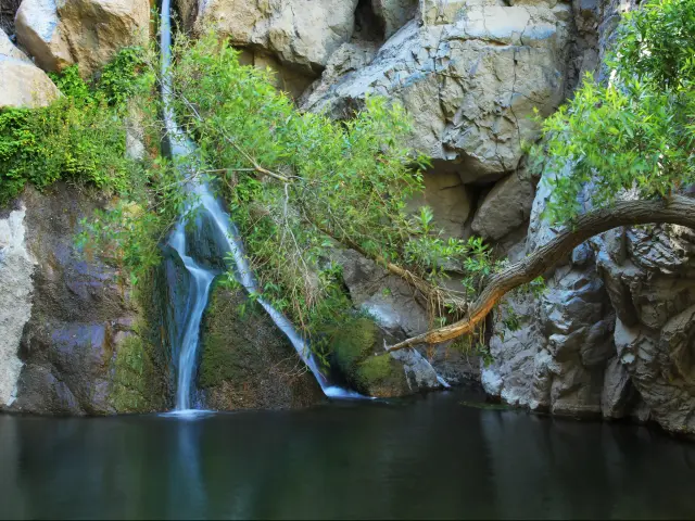
12. Darwin Falls
What makes this photo spot special: Darwin is far removed from the park's most popular landmarks, and it's much less visited as a result.
It's a true desert oasis so it has a much greener appearance than other parts of Death Valley, with the star attraction being its 20-foot waterfall with a rock splitting the flow of water into two streams on the way down.
How to get there: Unlike most of the attractions of Death Valley National Park, you'll access this one via the park's West Entrance. This is reached from Olancha by driving east on CA-190.
Continuing along CA-190 you'll pass Father Crowley Overlook and the Star Wars Canyon. Then, before reaching Panamint Springs, turn right onto Old Toll Road and follow the dirt road here for 2 miles.
Best time to visit: Make sure you've concluded your hike before 10am. It's a 2-mile round trip, so allow plenty of time to get out and back before then.
Even though the oasis at the end of the trail might look tempting, you aren't allowed to cool off in the water here because it's a drinking source for Panamint Springs.
Where to park: Darwin Falls has a dedicated parking lot on Old Toll Road. Park up here to begin your hike to see the falls.
13. Ubehebe Crater
What makes this photo spot special: This huge crater, which measures half a mile in diameter, makes for an unworldly viewing experience and some really striking photos.
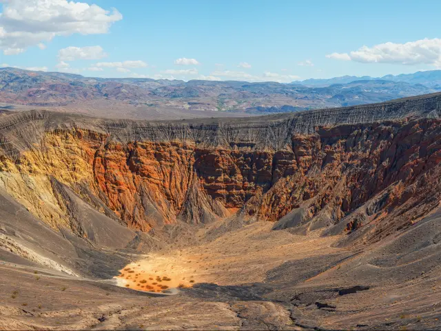
While it might look like a movie set depicting a meteor strike or UFO crash, the crater was in fact created by a volcanic explosion an estimated 2,100 years ago.
How to get there: Entering the park from Beatty on NV-374 S, continue onto Daylight Pass Road then turn right onto Scotty's Castle Road and drive for 33 miles.
You'll be traveling through the wide-open landscapes of Death Valley National Park so don't miss the chance to pull up for more photos along the way where it's safe to do so.
At Grapevine Canyon, turn left onto Ubehebe Crater Road and follow it for just over 5 miles until you reach the parking lot.
Best time to visit: If you're planning on hiking to the bottom of the crater then definitely avoid visiting in summer. It's very open here and the sun can be overbearing.
Where to park: There's a paved parking lot that looks right out across the crater. From here you can hike to the bottom of the crater or around the rim.

Sasha Yanshin – Co-Founder & Lead Driver
Sasha Yanshin has spent the last 15+ years mapping and driving thousands of miles across Europe and the US. As the Co-Founder and Lead Driver of Lazytrips, he brings an analytical approach to road-tripping, sharing meticulously tested routes, realistic drive times, and the hard-earned logistical reality of the open road.
Read full bio