The Best Pacific Coast Highway Photo Spots: Our Complete Guide (with map!)
The Californian coast has been the backdrop of countless iconic films and more than a few default desktop backgrounds. A single road, the Pacific Coast Highway, stretches for almost 700 miles all the way from the redwood forests of Northern California to the nearly tropical beaches of Orange County.
In our list of the 26 best photo spots along the Pacific Coast Highway, you'll find places to capture rugged cliffs, rustic lighthouses, iconic bridges, and sun-soaked scenes of life by the sea. This scenic road is dotted with perfect photo ops.
In the age of Instagram, increasingly niche and spectacular sights to be seen along the California coast are reaching a new global audience. Why not take your own picture-perfect trip along one of America's most famous coastlines?
| Section | Photo spots on this stretch of the Pacific Coast Highway |
|---|---|
| Between Leggett and San Francisco | Glass Beach, Bodega Bay, Golden Gate Bridge, and much more besides. |
| Between San Francisco and Monterey | Choose from Half Moon Bay, Shark Fin Cove, Monterey Bay and other great spots |
| Between Monterey and San Simeon | Includes Carmel-by-the-Sea, Bixby Creek Bridge, Big Sur and McWay Falls |
| Between San Simeon and Dana Point | Highlights such as Morro Bay, Bubblegum Alley, Point Dume and Venice Beach |
If you'd like to see a full table with each photo listed individually, just skip to the end of this article for our summary. And if you'd like to see where our photo spots fall along the route itself, take a look at the map we have included below.
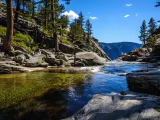
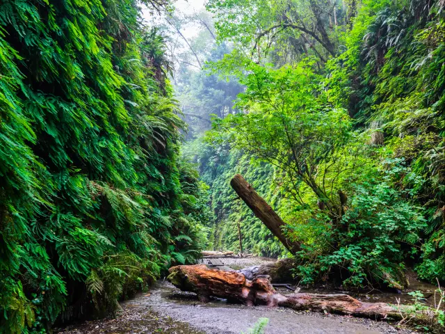
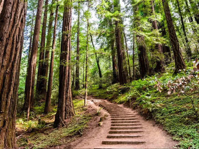
Before you set out on the Pacific Coast Highway: Fern Canyon, Redwood National and State Parks
2 hours 30 minutes (135 miles) north of Leggett
19 hours 25 minutes (840 miles) from Dana Point
What makes this photo spot special: This is a bonus in the far north of California that you won't want to miss if you plan on driving the whole California coast. In case you haven't noticed, there are many places where CA-1 and US-101 overlap.
Though the US-101 has some inland stretches, in the northern reaches of Humboldt and Del Norte Counties, it becomes a breathtaking coastal route after CA-1 officially ends in Leggett.
Fern Canyon sits in Redwood National and State Parks and is reachable after a moderate 5-mile hike along the James Irvine Trail. It is truly awe-inspiring; once you're here you feel like you've reached a land that time forgot. Even the amazing pictures you can take here won't truly do it justice.
How to get there: Hop on US-101 North from Leggett, driving past Eureka and Arcata, all the way to Berry Glenn. Once you pass the few motels in town, look out for the Newton B. Drury Scenic Parkway on your left. This will take you to the visitor center and trailhead to Fern Canyon.
Best time to visit: Being a temperate rainforest, you are liable to catch a drizzly day any time of the year. Due to the dense foliage, this is a place you can photograph during midday without it seeming washed out. The morning is also a great time to take pics here.
Bonus: Fern Canyon was used to portray the untamed world where dinosaurs roam in “The Lost World: Jurassic Park” (1997) as well as in “The Tree of Life” (2011).
Where to park: This is one of the few spots on this list without nearby parking. Fern Canyon is at least a few miles' hike from the nearest parking lot in the park near the Prairie Creek Visitor Center.
1. Coast Highway Lookout
40 minutes (20 miles) from Leggett
16 hours 10 minutes (675 miles) from Dana Point
What makes this photo spot special: If you plan on driving the Pacific Coast Highway (CA Route 1) all the way from its origin in Leggett, this is the first place where you get a panoramic view of the rugged Mendocino Coast.
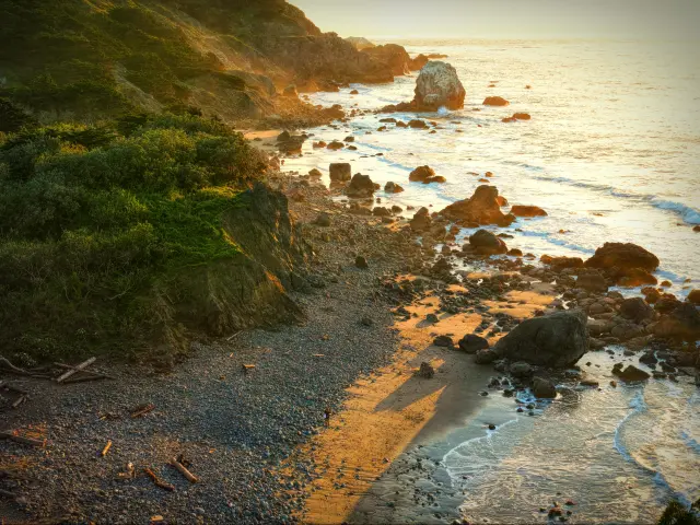
Where is it located on the route: This lookout is located directly on the route.
Best time to visit: There's no such thing as unflattering light for a view like this. As with all the stops on this coastal trip, the golden hour before the sun sets over the distant horizon of the Pacific Ocean will be particularly magical.
To capture the deep blue hues of the water, anytime in the morning before the sun gets too high in the sky will also be good.
Note that the summer can actually be a foggy time of the year, so spring and fall will provide the clearest morning and evening skies.
Where to park: While there isn't a dedicated parking lot, this lonely stretch of road has a wide gravel shoulder where you can stop to take pics and revel in the coastal views.
2. Glass Beach, Fort Bragg
1 hour 10 minutes (40 miles) from Leggett
15 hours 45 minutes (655 miles) from Dana Point
What makes this photo spot special: Few would believe that the many hues of smooth, pebble-sized glass which make up Glass Beach are the remnants of an old dump site. In addition to being an inspiring story of trash turned into treasure, this is a fun beach for macro and sunset photography.
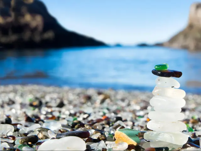
Where is it located on the route: This photo-perfect beach is located on the route.
Best time to visit: This beach is best suited for the sunset when you can get stunning pictures of amber sunlight gilding the multicolored pieces of glass.
Bonus: While Glass Beach itself hasn't been featured in any major shows or films, Fort Bragg has been the backdrop of a few scenes from “One Flew Over the Cuckoo's Nest” (1975) and “The Majestic” (2001).
Where to park: There's a dedicated parking lot for Glass Beach in Fort Bragg. You'll have to walk a little way and down some uneven stairs to get to the beach.
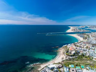
3. Bodega Bay
4 hours (150 miles) from Leggett
13 hours 5 minutes (545 miles) from Dana Point
What makes this photo spot special: In addition to being a seaside town that is easy on the eyes and bursting with leisure activities, from hiking and kayaking to wine tasting, there are several historic buildings here that have featured prominently in a classic Hitchcock film.
Where is it located on the route: This is another scenic photo spot that is located directly en route.
Best time to visit: The summer months tend to bring in the morning fog. This is one location where the fog might work to your advantage if you want to recreate any scenes shot by the master of suspense films himself.
Bonus: Bodega Bay is the well-known filming location of Alfred Hitchcock's avian horror film "The Birds" (1963). Fans of the director and weekend vacationers continue to flock to this harbor town.
Potter Schoolhouse and the Tides Wharf and Restaurant are two buildings whose exteriors you might recognize from the film. The former is currently a private residence so be respectful of their privacy if you want to take pictures there.
Where to park: There are several parking lots and places to park along the street, but keep in mind that weekends, particularly in the summer, can get busy.
4. Muir Beach Overlook
5 hours 20 minutes (200 miles) from Leggett
12 hours (495 miles) from Dana Point
What makes this photo spot special: Many people who make the short trip north from San Francisco to see Muir Woods miss out on the breathtaking coastal views, a narrow ridge trail, and WWII-era base end stations at Muir Beach Overlook in the Golden Gate National Recreation Area.
Where is it located on the route: This overlook is located on the route as you approach San Francisco, so you won't need to take a detour.
Best time to visit: While many people flock here for the perfect sunset shot, we think it is stunning any time of the day. In the late morning you can catch many contrasting hues between the ocean, sandy paths, and hills covered in chaparral.
This overlook is at its most photogenic on a clear day, when you can see features of San Francisco as well as the Farallon Islands, so spring and fall would be better times to photograph this area with peak visibility.
Bonus: If you skip Muir Woods (next on list) and take CA-1 from Muir Beach to Mill Valley and US-101, you'll be driving on the same scenic stretch of road as Michael Douglas and Sharon Stone in that hair-raising car chase scene in “Basic Instinct” (1992).
Where to park: You can park in a nearby lot that also has some basic amenities.
5. Muir Woods National Monument
5 hours 30 minutes (200 miles) from Leggett
11 hours 50 minutes (490 miles) from Dana Point
What makes this photo spot special: Muir Woods is simply enchanting. For decades it has attracted tourists and professional photographers alike who seek to capture the sun streaming between gigantic trunks of old-growth redwoods, highlighting the emerald ferns below.
Where is it located on the route: Muir Woods National Monument is located slightly inland from CA Route 1. Just after Muir Beach take a left on to Frank Valley Road, which will take you to the visitor center and several trailheads.
Best time to visit: For the most dramatic lighting when the sun hits the forest at an angle, aim to be in Muir Woods in the early morning or late afternoon.
Being a temperate forest, it never gets too hot or too cold here, but it can get very foggy. Sometimes this is a nice effect to photograph and you'll most likely see mist among the trees between May and August.
Bonus: Oddly enough, Muir Woods was the setting of a movie that was actually filmed elsewhere. The titular apes in “Rise of the Planet of the Apes” (2011) made Muir Woods their home on the edge of the San Francisco Bay Area, but these forest scenes were shot in British Columbia:
Where to park: As a national monument, there are parking lots and amenities in Muir Woods, but due to the grove's overwhelming popularity, there's a very slim chance of getting a parking spot on a weekend or holiday.
To help maintain accessibility, the park runs a shuttle from a free parking lot in nearby Larkspur on weekends and holidays.
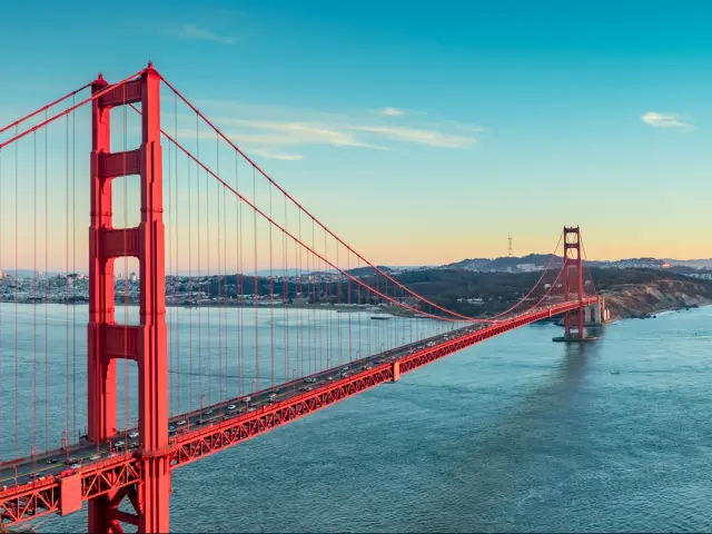
6. Golden Gate Bridge Viewpoint
6 hours (220 miles) from Leggett
11 hours 25 minutes (480 miles) from Dana Point
What makes this photo spot special: This is perhaps the most iconic photo spot on the entire trip. An engineering marvel from the great depression, the copper-red cables of the Golden Gate Bridge are recognizable the world over.
On one side you have the great expanse of the Pacific Ocean and on the other glimpses of sleek and stylish San Francisco. This viewpoint in the Marin Headlands is itself a gorgeous area to explore after you take the requisite bridge pic.
Where is it located on the route: CA Route 1 joins US Route 101 in Manzanita and heads towards the Golden Gate Bridge. Before you reach the bridge take the Alexander Avenue exit and follow Bunker Road and McCullough Road to Conzelman Road where the viewpoint is.
Best time to visit: Once again, this is a place that takes on a whole different life during the golden hour around sunset, though a sunrise pic from here can also be inspiring.
If you want a clear, panoramic view, then avoid the morning fog of the summer months.
Bonus: From the opening of the late 80s sitcom “Full House” to being destroyed in countless movies – check the bridge's Wikipedia page for the complete list – just one glimpse of this bridge tells you you're in San Francisco.
Perhaps the only other iconic American structure with more cinematic clout is the Statue of Liberty in New York.
Where to park: There's a parking lot for this popular overlook on Conzelman Road, just a few minutes' walk from the viewpoint. Here you'll also find restrooms and a few trails in case you feel like stretching your legs on a hike with spectacular views.
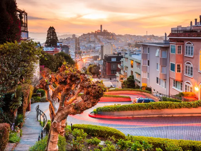
7. Lombard Street, San Francisco
6 hours (220 miles) from Leggett
11 hours 15 minutes (475 miles) from Dana Point
What makes this photo spot special: In the midst of famously hilly San Francisco, Lombard Street adds an additional challenge for drivers on one of its steeper sections coiled into eight hairpin turns.
Often touted as the “most crooked street in the world,” Lombard Street is one of the most recognizable residential areas in San Francisco on account of its unconventional angles.
Where is it located on the route: This world-famous photo spot is located in San Francisco, so you will need to make a short detour into the city from the Pacific Coast Highway.
How to get there: After crossing the Golden Gate Bridge CA-1 and US-101 split up again. To get to Lombard Street, follow US-101 South for 4 miles through the city.
Best time to visit: Due to the east-west orientation of the street as well as its slope, it catches better light in the morning. Also, the meticulously maintained gardens of the million-dollar homes which line the street are especially colorful in the late spring.
Bonus: Lombard Street looks like a tongue-twister became a road, making it an especially wacky spot for chase scenes, like in the movies “What's Up, Doc?” (1972) and “Ant-Man and the Wasp” (2018). An animated version of its classic curves is also featured in Pixar's “Inside Out”(2015).
Where to park: There is parking at Lombard Gardens on Hyde Street. Also, consider checking out George Sterling Park nearby. Here you can get some fantastic views of San Francisco and see the Golden Gate Bridge from a new angle.
8. Half Moon Bay
6 hours 40 minutes (245 miles) from Fort Bragg
10 hours 40 minutes (450 miles) from Dana Point
What makes this photo spot special: Half Moon Bay is a small fishing and agricultural town with charm to spare. Here we've given the coordinates for Miramontes Point, an ideal place to take pictures of coastal cliffs.
If you make this trip in the early spring, the bluffs will be covered with bright yellow mustard and other wildflowers.
Where is it located on the route: Take CA-1 through the main drag of Half Moon Bay, on your right look out for Miramontes Point Road which will take you to one of many local viewpoints over the Pacific Ocean.
Best time to visit: Depending on the vibe you want to capture, you can take great photographs here at any time of the day or year. Half Moon Bay has many curves, coves, and cliffs, meaning you can shoot the water and surrounding hills from many aesthetically pleasing angles.
Boats are another subject you'll have an opportunity to click photos of at the nearby Pillar Point Harbor.
Bonus: A surprising variety of films have shot one or more scenes in Half Moon Bay, including “The Right Stuff” (1983), “American Wedding” (2003), “The Etruscan Smile” (2018), and one of our favorite cult classics “Harold and Maude” (1971).
Just north of Half Moon Bay you'll find the quiet Moss Beach. Producers of “Memoirs of a Geisha” (2005) found the area so strikingly similar to the coast of Japan, that they constructed a fake Japanese house on one of the bluffs of the Fitzgerald Marine Reserve for a brief scene of a fishing village.
Where to park: There is parking at the trailhead for the California Coastal Trail on Miramontes Point Road, as well as near the beach and at the harbor.
9. Pigeon Point Lighthouse
7 hours (270 miles) from Leggett
10 hours 10 minutes (430 miles) from Dana Point
What makes this photo spot special: Towering 115 feet over a boulder-strewn bluff, separating verdant fields from the azure ocean, the shimmering, white pillar of Pigeon Point Lighthouse has been a beacon on the Pacific Coast since 1872.
Tourists and photographers have flocked here for almost as long and it is often cited as the most photographed lighthouse in California.
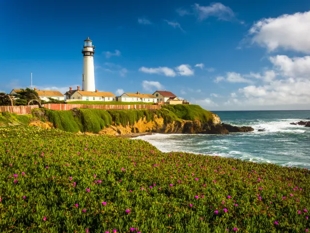
Where is it located on the route: This beautiful lighthouse is located on the route past Pescadero.
Best time to visit: Counterintuitively, this lighthouse perched on the very edge of the West Coast is best suited to the morning light of the sunrise. While during the sunset you might get the rich orange and red hues, they backlight the lighthouse.
This could work if you want to capture a silhouette against a stunning background, but not so much if you're interested in capturing the details of the lighthouse as a structure.
The lighthouse was first lit on November 15, 1872, and every year on or around November 15th there's commemorative lighting which provides a unique opportunity for some nighttime shots using a tripod.
Bonus: Despite its charm and undeniable photogenic setting, Pigeon Point isn't a particularly famous lighthouse. It did make an appearance in the star-studded, but critically panned, “Final Analysis” (1992).
Where to park: This is a remote rural location, so there is plenty of parking along the street leading to the lighthouse. It can sometimes be crowded on sunny weekends.
10. Shark Fin Cove
7 hours 20 minutes (280 miles) from Leggett
10 hours (415 miles) from Dana Point
What makes this photo spot special: A recent study has shown that sharks are near swimmers in CA waters a shocking 97% of the time. Luckily, Shark Fin Cove gets its name from an uncanny rock formation, and it is one of the most beautiful hidden beaches in Northern California.
Many people also set up frame-in-frame shots of the Shark Fin outcrop from a cave located along the cove.
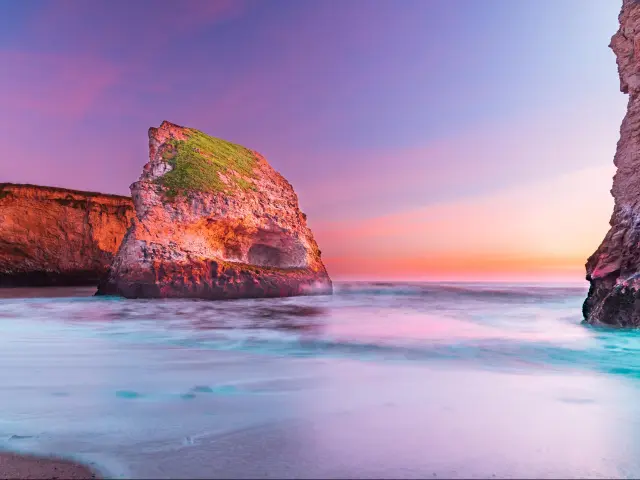
Where is it located on the route: A little further ahead as you drive south on PCH, you will reach this spot past Davenport.
Best time to visit: On a warm sunny day, expect to have lots of beachgoers in your shot. If you want to capture a people-free nature shot without the need for Photoshop, come on a cool, clear winter day. This is also a prime location for spectacular sunset photography.
Bonus: This eye-catching cove hasn't made it to the silver screen yet, but it would be an enticing setting for an amateur film.
Where to park: Shark Fin Cove has a dedicated parking lot located right on CA-1.
11. Monterey
8 hours 20 minutes (335 miles) from Leggett
8 hours 45 minutes (360 miles) from Dana Point
What makes this photo spot special: With panoramic ocean views, charming streets, and a world-class aquarium, anyone who's ever been to Monterey knows that it would serve as a beautiful backdrop and many filmmakers have incorporated its cypress-strewn beaches into their work.
Where is it located on the route: The town is located between CA-1 and the ocean, on a small peninsula. Take the Del Monte of Fremont Street Exits and follow signs to Cannery Row or Pacific Grove depending on where you want to hold your photo shoot.
Best time to visit: Once again, be prepared for fog during the warmer months. The weather and views are at their best in the spring and the fall. Parts of the town and coast can be captured any time and this is a location that deserves a whole day of exploration at the very least.
Bonus: Glimpses of Monterey can be seen in blockbusters like “Forrest Gump” (1994) and “Legally Blonde” (2001). Most recently it has served as the primary setting for HBO's “Big Little Lies" (2017-2019).
Linking art and life, "Cannery Row" (1982) is a movie shot in Monterey based on former resident John Steinbeck's Depression-era novel. Finally, dedicated Trekkies will remember the humpback whale scenes and shots of the Monterey Bay Aquarium from “Star Trek IV: The Voyage Home” (1986).
Where to park: There are parking garages near Cannery Row and all along Ocean View Blvd. If you're more interested in nature photography, there's parking at the Monarch Butterfly Sanctuary in Pacific Grove and at Asilomar State Beach.
12. Carmel-By-The-Sea Beach
8 hours 30 minutes (340 miles) from Leggett
8 hours 35 minutes (360 miles) from Dana Point
What makes this photo spot special: Beyond being a picturesque coastal town with white sand beaches and old-world charm, Carmel-by-the-Sea has had star power at its helm. Acclaimed actor and director Clint Eastwood was once the town's mayor and has shot several films here.
Where is it located on the route: Similar to Monterey, Carmel is located between CA-1 and the sea and you'll have to make a quick hop off the freeway along Ocean Avenue to get to the town and beach.
Best time to visit: While sunsets at the beach are a popular subject of photos, the town looks cute as ever in the morning light.
Carmel turns up the charm even higher during the weeks leading up to Christmas. This would be a great place to take a family holiday pic for a Christmas card.
Bonus: In addition to Eastwood's "Mystic River" (2003) and "Million Dollar Baby" (2004), scenes from “Basic Instinct” (1992), “Hail, Caesar!”(2016), and the original “Parent Trap” (1961) were shot in Carmel.
Where to park: Carmel is a tiny, walkable town with several public parking lots on Torres Street and Ocean Avenue. On weekends and holidays, you might be hard-pressed to find a spot around mealtimes and sunset.
13. Calla Lily Valley
8 hours 40 minutes (350 miles) from Leggett
8 hours 20 minutes (350 miles) from Dana Point
What makes this photo spot special: It's almost like Big Sur has an inexplicable inferiority complex and is constantly trying to outdo itself. This otherwise unassuming valley towards the north of this famous coast bursts into a spectacular carpet of calla lilies every spring.
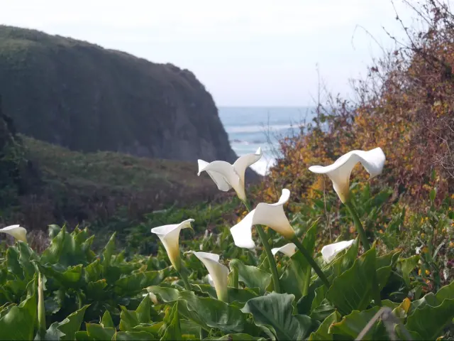
Where is it located on the route: Right on CA-1 a few miles south of Carmel, look out for a dirt turnout on your right shoulder and the beginning of the Garrapata Trail which goes to Garrapata Beach. The lilies are to be seen along the trail.
Best time to visit: Of course, the proverb claims there is no need to gild the lily, but these lilies sure do look amazing in the light of the golden hour. If you can't make it for sunset, the bright white of the lilies at midday contrasts beautifully with the deep blue of the ocean background.
The pristine, alabaster lilies take over the valley floor in the early spring. Not that this isn't a beautiful place to explore year-round, but for capturing the calla lilies in their full glory aim to come between late January and early April.
Bonus: This is a photo spot that has gained fame during this age of Instagram, rather than from any big screen appearances.
Where to park: There isn't much parking save for the shoulder of the highway. As this place has become less of a local secret, parking can be difficult on the weekends and holidays.
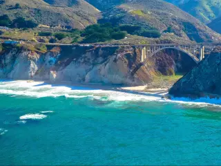
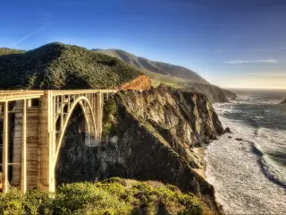
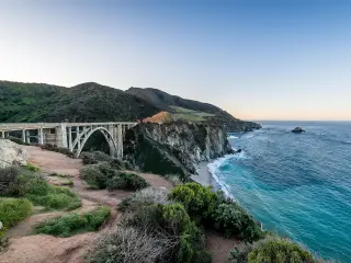
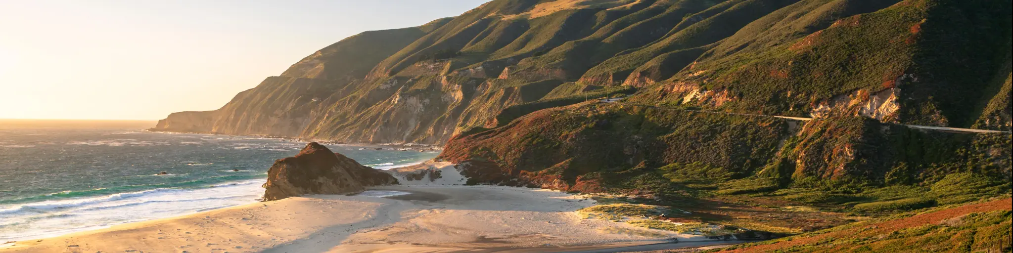
14. Bixby Creek Bridge
8 hours 40 minutes (350 miles) from Leggett
8 hours 10 minutes (340 miles) from Dana Point
What makes this photo spot special: The magnificence of Big Sur easily lends itself to nature photography, yet it is the meeting of the natural world and human ingenuity which makes the Bixby Creek Bridge such a beloved photo spot along the Pacific Coast Highway.
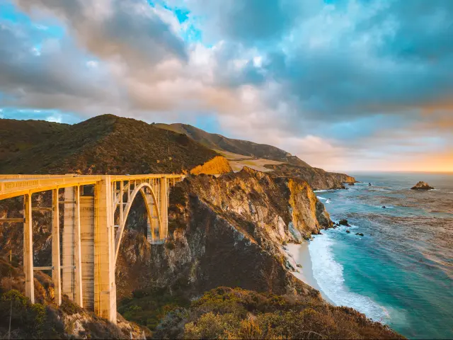
Where is it located on the route: This scenic bridge is one of the top photography locations in California and is located to the south of Monterey on the route.
Best time to visit: This is another spot that's pretty irresistible during sunset, but we also think the diffuse early morning light can produce some shots worthy of posting.
The bridge is beautiful in every season, just be aware of occasional road closures along this stretch of CA-1 and check the CalTrans website before you leave Carmel.
Bonus: This is the bridge features two familiar names from this list: it's in the title sequence of “Big Little Lies" (2017-2019) and also has a cameo in “Basic Instinct” (1992). Mr. Eastwood also included it in his 1971 drama-thriller “Play Misty for Me.”
Where to park: There's a parking lot near the viewpoint to the right of the road, but there aren't any other amenities out here. Be forewarned that this is another popular spot for a weekend trip and it can get crowded.
15. Point Sur and Point Sur Lighthouse
9 hours (360 miles) from Leggett
7 hours 55 minutes (340 miles) from Dana Point
What makes this photo spot special: Point Sur is remarkable in itself, a large volcanic rock rising up from a narrow strip of land jutting into the ocean, but it is also home to a quaint turn-of-the-century lighthouse.
You might want to stop and photograph this location as you approach it.
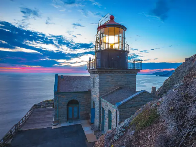
Where is it located on the route: Located directly on the route, just before you reach Pfeiffer Big Sur State Park.
Best time to visit: A bit of mist adds to the mystique of this lonely lighthouse, so we think no matter what time of the year you come, you'll be able to take some impressive pictures here.
You can also tour the lighthouse at 10 a.m. on weekends in case you want to see it up close. Keep in mind that this involves a 1.5-mile hike up a steep hillside.
Bonus: This is another site that hasn't gotten the screen time it deserves, but it did feature in a 2012 episode of the documentary series “Ghost Adventures.”
Big Sur's signature cliffs can also be seen in "The Sandpiper" (1965) with Elizabeth Taylor and Richard Burton.
Where to park: There is parking at the edge of the state historic park which contains the lighthouse.
16. Pfeiffer Beach
9 hours 20 minutes (370 miles) from Leggett
7 hours 30 minutes (320 miles) from Dana Point
What makes this photo spot special: In addition to being one of many spectacular beaches along the Big Sur Coast, Pfeiffer Beach is also where you can find waves crashing over purple sand and the highly Instagrammable Keyhole Arch.
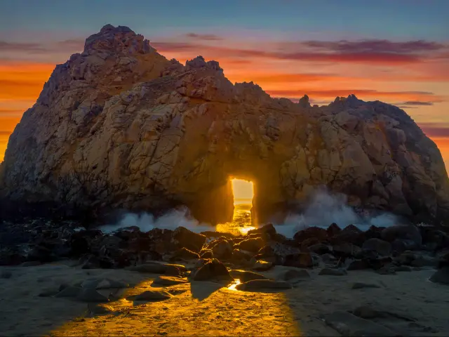
Where is it located on the route: You can reach Pfeiffer Beach after a short drive along Sycamore Canyon Road after exiting CA-1 at the Pfeiffer Big Sur State Park sign.
Best time to visit: This beach is worth the stop no matter when you're able to make this trip, but it is obviously another preferred location for a sunset photoshoot.
Every winter an incredible opportunity awaits the patient photographer: for the first two weeks in January the setting sun lines up perfectly with the keyhole of Keyhole Arch.
This is understandably a busier time at the beach, but if you come early and stake your spot, you'll get a picture of a lifetime.
Where to park: Being a state park, there are maintained lots at the entrance to the beach. On the other side of the highway, there's also a campground in case you wanted to spend a few days capturing the many moods of Big Sur
17. McWay Falls, Julia Pfeiffer Burns State Park
9 hours 30 minutes (380 miles) from Leggett
7 hours 20 minutes (320 miles) from Dana Point
What makes this photo spot special: This secluded cove is a little slice of tropical paradise in Central California, complete with a graceful waterfall pouring into the ocean. If fact, this is known as a tidefall and is one of only two in the state.
Even on a jam-packed trip, you'll be tempted to spend a little more time here.
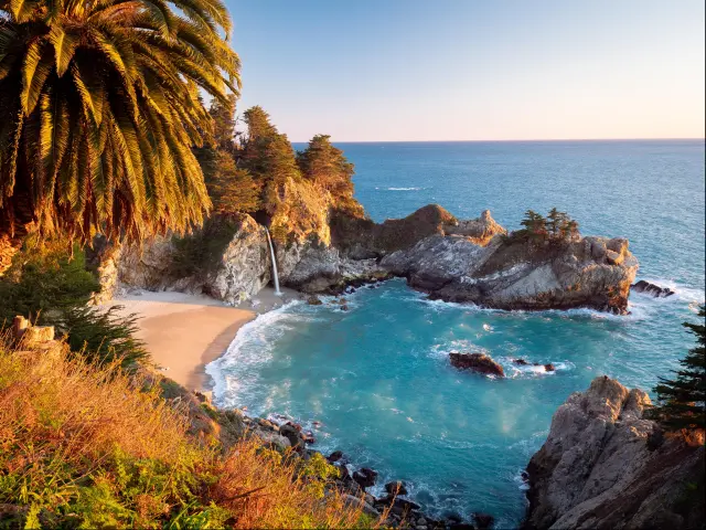
Where is it located on the route: These tranquil waterfalls are located to the south of the previous photo spot, directly en route.
Best time to visit: Anytime in the afternoon when the light is pouring into the cove will be a good time to take pictures here. It is also popular during sunset, but we think the early afternoon light makes all the colors really pop and bring out the cove's tropical vibe.
Unlike many waterfalls in the state, this one is usually flowing year-round.
Where to park: There's a small parking lot with basic bathrooms near the trailhead. There aren't many spaces, but people are coming and going frequently so if it's full you shouldn't have to wait long to nab a spot. The viewpoint is about a 5-10 minute walk along the small trail from the lot.
18. Ragged Point
10 hours 10 minutes (400 miles) from Leggett
6 hours 53 minutes (293 miles) from Dana Point
What makes this photo spot special: This is the southernmost point of Big Sur and the first glimpse of its famous cliffs for people coming from Southern California.
In addition to breathtaking views, there are several sculptures and mosaics that can be incorporated into your pictures to add another dimension to the usual Big Sur album.
Where is it located on the route: As you travel further south on PCH, you will reach this spot just before San Simeon.
Best time to visit: Once again the afternoon and sunsets are the preferred times to photograph Ragged Point. Try to come in the spring so you can catch all the wildflowers in full bloom, adding dabs of color to those panoramic shots.
Where to park: Ample parking and amenities are available after a long stretch of road along undisturbed nature. Behind the restaurant and inn, you'll find a trail to the “Portal to Big Sur” sculpture.
19. Elephant Seal Vista Point
10 hours 50 minutes (420 miles) from Leggett
6 hours 20 minutes (275 miles) from Dana Point
What makes this photo spot special: There aren't many places on earth where you can see up to 17,000 elephant seals. While they might not always be at this San Simeon Vista point in such overwhelming numbers all the time, you can usually spot at least a few of them here throughout the year.
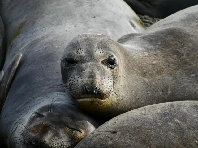
Where is it located on the route: Similar to Ragged Point, this stop is located just before reaching San Simeon.
Best time to visit: It's best to come here in the early morning when the seals are still on the beach before heading out to the water. They're usually gone by 8am and return in the late afternoon.
To see more seals as well as catch some of the sparring males, try to come in late January and February. April and October also tend to be more popular months to see seals here.
Bonus: The nearby beach of San Simeon was a stand-in for a South American location in former California Governor Arnold Schwarzenegger's “Commando” (1985).
Where to park: There's a big parking lot just off the highway for people coming to the viewpoint.
20. Hearst Castle, San Simeon
11 hours (420 miles) from Leggett
6 hours 10 minutes (270 miles) from Dana Point
What makes this photo spot special: This iconic, 165-room mansion rightfully deserves to be called a castle of the American West. Its many architectural influences stem from William Randolph Hearst's boyhood trip to Europe; its halls are filled with antiques and curios.
Fortunately for us humble members of the public, the estate was opened for tours following Hearst's demise and photography is allowed both inside and outside the premises.
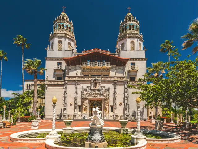
Where is it located on the route: Hearst Castle Visitor's Center is about half a mile inland down Hearst Castle Road off CA-1.
Best time to visit: The castle is open daily for tours starting at 9 a.m. and they even conduct several nighttime tours. It's very busy during the summer, so visiting in the spring or fall will give you more space and time to frame the perfect shot.
Bonus: Hearst Castle was the inspiration for Xanadu, the fictional mansion in "Citizen Kane" (1941) and William Hearst himself was the inspiration for the protagonist, although the actual filming didn't take place here.
The opulent Neptune Pool from Hearst Castle does make an appearance in Kirk Douglas's classic “Spartacus” (1960).
Where to park: There's free parking at the Visitor Center, where you'll also need to buy tickets to tour the castle on your own or on one of their many guided tours.
21. Morro Bay
11 hours 10 minutes (430 miles) from Leggett
5 hours 50 minutes (255 miles) from Dana Point
What makes this photo spot special: Morro Bay is visually anchored by the imposing Morro Rock, which catches the light in fantastic ways throughout the day, adding depth and character to the already gorgeous Pacific vistas.
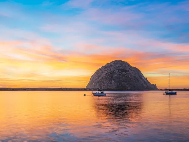
Where is it located on the route: Morro Bay is located on PCH just to the south of Cayucos.
Best time to visit: The early morning, midday, and sunset are all fabulous times to take pictures around Morro Bay. There's a marina and some adorable restaurants and shops along the bay which can add variety to the photos you snap here.
Of course, the golden hour and sunset can produce mesmerizing technicolor backdrops that fey-savvy photographers are able to pass up.
The temperate central coast doesn't change much between seasons and is busiest during the summer vacation.
Bonus: Morro Bay's recognizable outcrop can be seen in “The Lady from Shanghai” (1947) featuring Orson Welles as well as in “Patriot Games” (1992) starring Harrison Ford.
Where to park: There are several parking lots in the town, some closer to the beach and one right near the base of Morro Rock.
22. Bubblegum Alley, San Luis Obispo
11 hours 30 minutes (445 miles) from Leggett
5 hours 35 minutes (240 miles) from Dana Point
What makes this photo spot special: Why not make a fun pit stop in San Luis Obispo and take a few lighthearted pics in Bubblegum Alley? If you feel so inclined, you can also make your own contribution to this ever-growing collective creation.
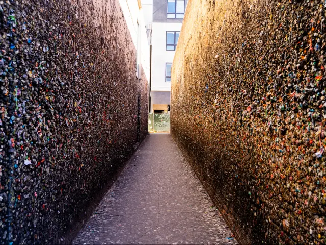
Where is it located on the route: Bubblegum Alley is right in downtown San Luis Obispo, take the Santa Rosa Street Exit and then drive a few blocks to Higuera Street. The alley is between there and Marsh Street, which you can take to join back up with CA-1/US-101.
Best time to visit: It is better to come in the morning or midday when the sun is high and there is plenty of light to bring out the color in the rainbow gobs coating the walls.
Bonus: This is another location that is more Instagram-famous than anything else.
Where to park: There is limited street parking as well as a public parking lot on Higuera Street
23. Monarch Butterfly Grove, Pismo Beach
11 hours 50 minutes (460 miles) from Leggett
5 hours 17 minutes (230 miles) from Dana Point
What makes this photo spot special: Monarch butterflies make a multi-generation migration across North America and this grove in Pismo Beach is one of the few places where you can see them in their thousands.
Capture eucalyptus boughs coated with these living leaves and get a few macro shots of their vibrant orange and black wings.
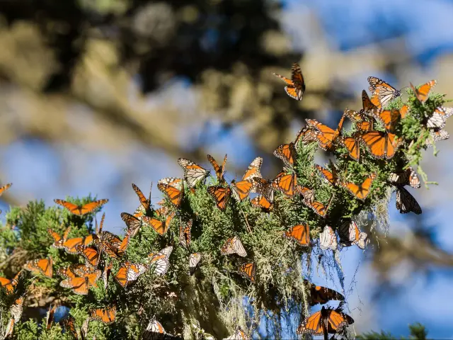
Where is it located on the route: The Monarch Butterfly Grove is directly off the Pacific Coast Highway, but make sure you exit to your right onto this highway from the shared stretch with US-101 as you enter Pismo Beach.
Best time to visit: The angular light of the early morning and late afternoon helps to create some contrast between hundreds of tiny wings.
You might need a telephoto lens to take sharp pics of butterflies high up in the canopy, but usually, there are a few hanging around more accessible bushes and shrubs.
The monarchs congregate here between November and February as part of their southern migration.
Bonus: While the majestic monarch butterflies are the perfect subject to brighten up your Instagram feed, they haven't been in any feature films.
Just to the south of Pismo Beach you'll find the Guadalupe-Nipomo Dunes, which have been a stand in for Middle Eastern filming locations in “Hidalgo” (2004), “Morocco” (1930), “The Thief of Bagdad” (1924), and “The Ten Commandments” (1923).
Where to park: You can park in the small lot at the grove and there are additional parking spots and facilities across the creek at Pismo State Beach.
24. Point Dume, Malibu
14 hours 50 minutes (620 miles) from Leggett
2 hours 15 minutes (75 miles) from Dana Point
What makes this photo spot special: Though most famous for being the earthly site of Charlton Heston's desperate cry at the end of “Planet of the Apes” (1968) Point Dume is a gorgeous beach bordered by sheer cliffs that have been featured in dozens of films.
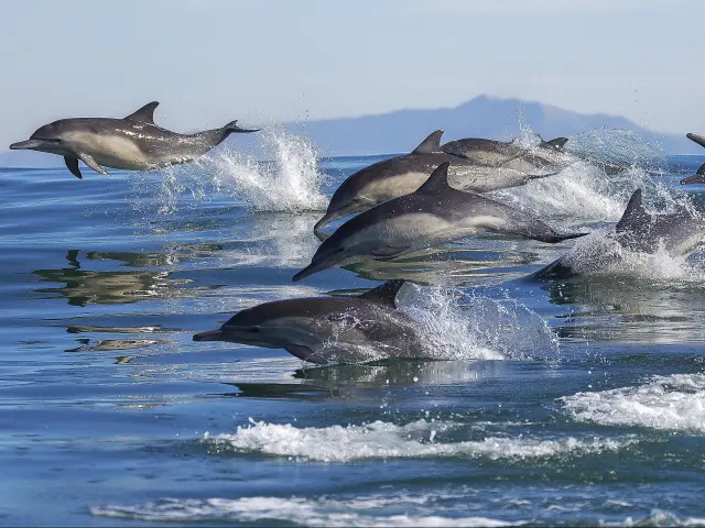
It is also one of the few places in southern California where you can see grey whales and dolphins from the land.
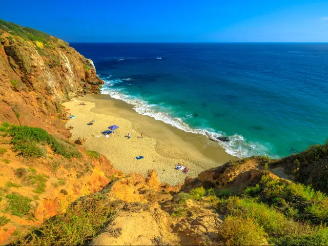
Where is it located on the route: As you drive past Oxnard en route, keep following PCH south, and Point Dume is located just before Malibu.
Best time to visit: You can get some stunning sunrise shots from the bluff, but down on the beach the afternoon and sunset are the best time to catch that golden light hitting the headlands.
Bonus: The famous beach scene at the end of "Planet of the Apes" (1968) was shot at Point Dume's Westward Beach. Point Dume also gets some screen time in “The Big Lebowski” (1998), “Iron Man”(2008), and “The Fablemans”
Where to park: There's parking at Point Dume State Beach. At the end of the long lot perched atop the bluff, you will find trailheads for exploring the nature preserve.
25. Santa Monica Pier
15 hours 20 minutes (635 miles) from Leggett
1 hour 30 minutes (60 miles) from Dana Point
What makes this photo spot special: At the western edge of vibrant Los Angeles, complete with a Ferris wheel and roller coaster, the Santa Monica Pier has been a beloved place for family fun and first dates for generations.
After you've worked your magic behind the lens, be sure to let loose and enjoy some of the rides while you're here. This is also the ending point of the legendary Route 66.
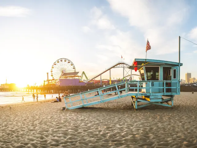
Where is it located on the route: Take a fresh breath of ocean air and snap a photo here just before arriving at Los Angeles on Pacific Coast Highway,
Best time to visit: This is a place that really comes to life as the sun goes down, so we recommend coming here at sunset or even later with a tripod to get some shots of neon lights reflecting off the surf and sand.
Bonus: The Santa Monica Pier appears at the end of "Forrest Gump" (1994) where Tom Hank's character decides to stop running. It can also be seen in “Her” (2013) and the TV series “The L Word” (2004-2009).
Where to park: Several parking lots and garages are on Santa Monica Boulevard, Colorado Avenue, and 2nd Street.
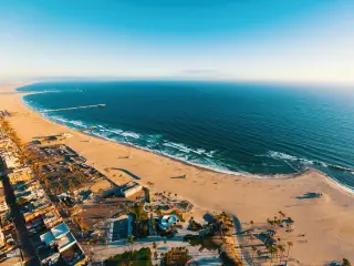
26. Venice Beach
16 hours 30 minutes (650 miles) from Leggett
1 hour 25 minutes (60 miles) from Dana Point
What makes this photo spot special: In some sense the scenes you'll capture here are how most of the world thinks of Southern California, or at least the version of the culture here that dominated the 80s and 90s.
From bright signs on a palm-tree-studded boardwalk to the open-air gym of Muscle Beach, this is a place that fully embraces life under the sun.
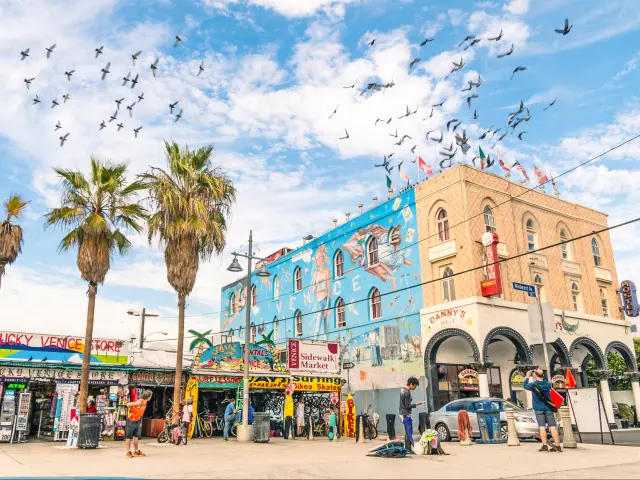
Where is it located on the route: Venice Beach is located just to the south of Santa Monica.
Best time to visit: There are many different subjects to photograph here and some of them might be better during the morning or midday, like the skate park and row of brightly colored ice cream shacks.
Yet most people agree that this is another place made for sunsets and the golden hour where the shadows of towering palms are even more elongated and dramatic.
Bonus: "Lords of Dogtown" (2005) details the birth of skateboarding in the 1970s in the places where it actually happened, including Venice Beach.
The Orson Welles classic "Touch of Evil" (1958) opens with a shot along the Venice Beach Boardwalk.
Where to park: There's a parking lot at Venice Beach as well as along S Venice Boulevard.
Please check our comprehensive guide out to learn more:
A summary of our favorite photo spots along the Pacific Coast Highway
| Photo Spot | Description |
|---|---|
| Coast Highway Lookout | This scenic lookout provides a spectacular panorama of the coastline |
| Glass Beach | A shimmering shoreline composed of tiny sea glass pebbles, reclaimed by nature |
| Bodega Bay | Views of rugged cliffs, rolling dunes and the sparkling Pacific Ocean |
| Muir Beach Overlook | Cliffside viewpoint with ocean views of sporadic sightings of whales and seals |
| Muir Woods | Home to towering, ancient redwood trees, creating a tranquil environment |
| Golden Gate Bridge | Iconic suspension bridge in San Francisco known for its distinctive red color |
| Lombard Street | Offers a unique zigzag driving experience with beautiful views of San Francisco |
| Half Moon Bay | Features miles of beautiful sandy beaches, cool tide pools, and cliffside views |
| Pigeon Point Lighthouse | One of the tallest lighthouses in the US offering breathtaking sunset views |
| Shark Fin Cove | A hidden gem featuring a large rock formation resembling a shark's fin |
| Monterey | Known for the Monterey Bay Aquarium, Cannery Row, and its Fisherman's Wharf |
| Carmel-by-the-Sea Beach | Features beautiful soft, white sand, cypress trees, and a nearby European-style village |
| Calla Lily Valley | Vibrant Calla lilies during spring, offering an enchanting view against the ocean |
| Bixby Creek Bridge | One of the most photographed bridges on the West Coast due to its architectural beauty |
| Point Sur Lighthouse | Beautiful lighthouse situated on a volcanic rock, offering panoramic views of the sea |
| Pfeiffer Beach | Famous for its purple sand and the Keyhole Arch, where sunset light creates beautiful scenery |
| McWay Falls | 80-foot waterfall that drops onto a secluded beach, offering one of the most iconic views of the coast |
| Ragged Point | Known as the "Million Dollar View," offering dramatic cliffside views of the coastline and the ocean |
| Elephant Seal Vista Point | A viewing area where visitors can observe elephant seals in their natural habitat |
| Hearst Castle | A National Historic Landmark mansion known for its ornate architecture and beautiful gardens |
| Morro Bay | Known for Morro Rock and its vibrant waterfront with unique shops and outdoor activities |
| Bubblegum Alley | A quirky alley covered with chewed gum left by passers-by, a unique roadside attraction |
| Monarch Butterfly Grove | In the winter, thousands of Monarch butterflies cluster on the limbs of Eucalyptus trees here |
| Point Dume | Features scenic coastal cliffs, a beautiful sandy beach, and great spots for watching dolphins and whales |
| Santa Monica Pier | An iconic destination with an amusement park, restaurants, and beautiful views of the Pacific |
| Venice Beach | Known for its bustling boardwalk, colorful murals, Muscle Beach outdoor gym, and the unique Venice Canals |
| Fern Canyon (North of the PCH) | This canyon has 50-foot high walls covered in ferns, creating a prehistoric-like atmosphere |

Sasha Yanshin – Co-Founder & Lead Driver
Sasha Yanshin has spent the last 15+ years mapping and driving thousands of miles across Europe and the US. As the Co-Founder and Lead Driver of Lazytrips, he brings an analytical approach to road-tripping, sharing meticulously tested routes, realistic drive times, and the hard-earned logistical reality of the open road.
Read full bio