Road Trip from Denver to Moab
Moab is a town in the heart of America's red rock country and the gateway to two iconic national parks - Arches and Canyonlands. The Colorado River runs through town and Dead Horse Point's overlook sits 30 minutes away - the landscape is dramatic in every direction.
The 355-mile drive from Denver runs west on I-70 through the Colorado Rockies via Vail, Glenwood Springs, and Grand Junction before crossing into Utah's red rock country.
Google Maps will tell you to turn south at Crescent Junction onto US-191, but the better final approach is to leave I-70 four junctions earlier at Cisco onto Highway 128 - a 44-mile scenic byway that follows the Colorado River through canyon country into Moab.
Once you arrive, the town itself is small and a bit touristy, but the parks, the river, and the canyons surrounding it make the drive more than worth it.
🚙 EXPLORE MORE: The Best Road Trips From Denver
Read this before you leave Denver
🏔️ Mountain Driving
The first 200 miles from Denver follow I-70 over Vail Pass (10,600 feet) and the Eisenhower Tunnel (11,158 feet) - the same high-altitude stretch as any other westbound trip from Denver. If you're flying in and immediately driving, expect to feel the altitude. Stop in Georgetown or Idaho Springs for 30 minutes to acclimate before the highest sections.
In winter, chain laws are routinely in effect on this stretch. Check CDOT road conditions before leaving Denver if you're traveling October through April.
🏜️ Book Months Ahead
Moab hotels can fill up months in advance. Summer (June-August) is the busiest because of summer vacation, but spring and fall are when serious park visitors come because the heat is bearable. So if you're visiting between March and October, try to book your hotel 3-6 months ahead.
Arches dropped its timed-entry reservation system for 2026, so you no longer need to book a specific arrival window - just show up during operating hours with your entrance pass. Parking lots can fill up at popular trailheads on weekends and holidays, so arrive early.
🌡️ Desert Heat
Moab is high desert and summer temperatures regularly exceed 100°F. Most trails in Arches and Canyonlands have zero shade. Bring large water bottles, and something to carry them - a small backpack or a shoulder strap - so you're not holding one in your hand all day.
Plan your big hikes for early morning and save the afternoons for driving, the river, or the hotel pool.
How many days do you need?
5 days is the minimum for this trip. 6 days is the sweet spot. Moab has two national parks, a state park, and the Colorado River - trying to see all of it in a long weekend means you're driving more than you're exploring.
The drive from Denver is 6 hours one way, so two of your days are mostly driving. Then you need at least one day for Arches, one day for Canyonlands, and one day for everything else. But Canyonlands is too big for a single day, so if you can, go for the optional extra day to see more.
Here's what each day looks like:
Day 1: Denver to Moab
🚗 355 miles ⏱️ 6 hours
Leave Denver in the morning and take I-70 west through the Rockies. Turn off at Cisco onto Highway 128 for the scenic final approach along the Colorado River. Arrive in Moab by late afternoon, check in, and find somewhere good for dinner.
Day 2: Arches National Park
Spend the full day in Arches. Get there early before the parking lots fill - work from the far end of the park road back toward the entrance. Delicate Arch is the marquee hike, the Windows section is easy and spectacular, and Devil's Garden has the longest trails if your legs still want more.
Day 3: Canyonlands - Island in the Sky
Drive 40 minutes from Moab to Island in the Sky, the nearest and most accessible district of Canyonlands. Mesa Arch at sunrise is iconic, Grand View Point at the end of the road is the one that will stick in your mind - the desert below looks like it cracked open, with canyons dropping a thousand feet straight down.
Optional Extra Day
The Needles
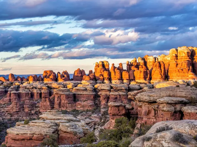
The Needles district of Canyonlands is 75 miles south of Moab and a completely different experience to Island in the Sky. Instead of looking down into the canyons from above, you're walking through them - surrounded by red and white sandstone spires, slot canyons, and rock formations you can scramble over. It's quieter, less visited, and feels far more remote than anything else on this trip.
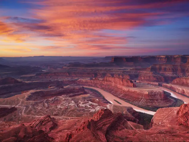
Day 4: Dead Horse Point & Colorado River
Start the morning at Dead Horse Point State Park - one of the most photographed overlooks in Utah, with a 2,000-foot drop to the Colorado River below. Head back to Moab for the afternoon and get on the river, the trails, or the bike.
Day 5: Drive back to Denver
🚗 355 miles ⏱️ 6 hours
Reverse the route east. If you didn't take Highway 128 on the way in because you were arriving late, take it now - I promise you'll be glad you did. Leave by mid-morning and you'll be back in Denver by late afternoon.
If you only have a long weekend, drive out on Friday morning, give Arches the full day on Saturday, and spend Sunday morning at Dead Horse Point before driving home. You'll miss Canyonlands entirely, but Arches alone is still a great trip.
Where to stay
Moab is simple - you only need one base for the whole trip. Most of the sights are within 40 minutes of town, so you don't need to move hotels or split your nights between different locations.
Most people book a hotel on Moab's Main Street, and that's fine - you're walking distance to restaurants and close to the Arches entrance. But the best place to stay isn't in town.
Red Cliffs Lodge is right on the river - it's 14 miles outside town on Highway 128 on the same scenic road you drove in on. Your room looks straight out onto the Colorado River with red cliff walls rising on both sides.
You see the Milky Way right above you before going to sleep and you wake up to see the horses in the paddock before you set off.
The trade-off is the drive. You're about 20 minutes from the Arches entrance, and if you want to eat out, you'll need a designated driver instead of walking back to your hotel.
The resort charges $20 for parking which is weird given it's in the middle of nowhere, but it's not as annoying if you know about it beforehand.
The route from Denver
If you want to stop over in the Rockies, or plan your day-by-day itinerary, you can build your own custom version of the route in the Planner
Head west out of Denver on I-70. The first two hours are the mountain stretch - Eisenhower Tunnel at 11,158 feet, Vail Pass at 10,600 feet, and the same high-altitude roads you'd take on any westbound route from Denver.
After Vail, the road drops into the Eagle River valley and the scenery shifts from alpine peaks to narrowing canyon walls. This stretch moves fast - Minturn, Avon, and Edwards blur past without much reason to stop.
Glenwood Canyon is where the drive gets genuinely spectacular. The interstate threads through a narrow gorge with 1,300-foot walls on both sides and the Colorado River right below you.
It's 12 miles of road that feels nothing like an interstate. There are pull-offs and rest areas built into the canyon walls - use them. This section goes by too quickly if you don't stop at least once.
Glenwood Springs is the natural lunch stop. It's about three hours from Denver and has proper restaurants, fuel, and the famous hot springs pool if you want to break up the drive.
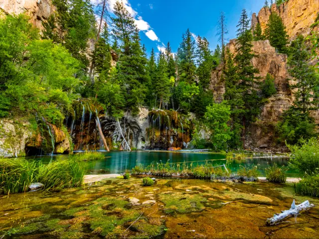
The Hanging Lake hike just before you get to Glenwood Springs is amazing, but it'll take 3 hours out of your day and you have to apply for the mandatory permit in advance.
West of Glenwood Springs, the landscape changes fast. The mountains flatten out, the air gets drier, and by the time you pass through Grand Junction you're in high desert. The Rockies are behind you.
Fill up in Grand Junction or Fruita. The next reliable fuel isn't until Moab, and the stretch in between is empty.
Stay on I-70 past Grand Junction and into Utah. This is where your route choice matters.
If you set Moab as your destination, Google Maps will send you to Crescent Junction and south on US-191 - it's slightly faster and completely forgettable. Flat desert highway, no views, and you arrive in Moab from the north having missed the best part of the drive.
Instead, take Exit 214 at Cisco. It's easy to miss - there's almost nothing there - but this puts you onto Highway 128, a 44-mile scenic byway that follows the Colorado River through red rock canyon country all the way into Moab.
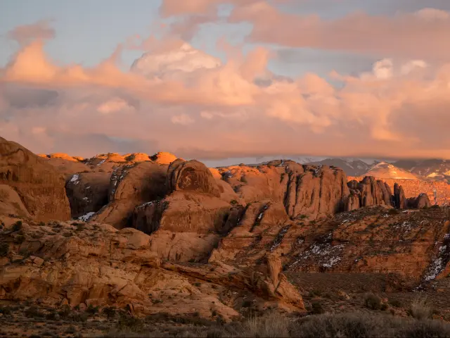
The road hugs the river with sandstone walls towering above you on both sides, and the landscape gets more dramatic with every mile. Fisher Towers and Castle Valley appear on your right as you get closer to town.
The Red Cliffs Lodge I recommended is on this road, so you can check in, drop your bags, and keep going to Moab for a walk and a cold beer.
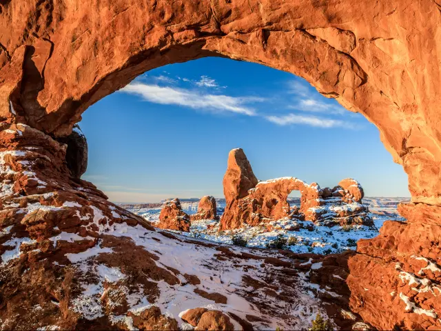
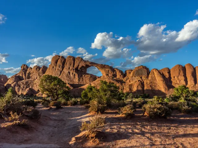
Arches National Park
Arches is the main reason to make this trip. Over 2,000 natural stone arches spread across a landscape of red rock fins, towers, and balanced boulders that look like they shouldn't exist. The park is compact enough to see the highlights in a single day if you start early and plan your route.
The entire park runs along one 18-mile dead-end road. Everything branches off it - every trailhead, every viewpoint, every parking lot. That means everyone enters and exits the same way, and by mid-morning the road and the lots near the popular stops are full.
The move is to drive to the far end first thing in the morning and work your way back toward the entrance as the day goes on. You'll be ahead of the crowds at every stop instead of fighting them.
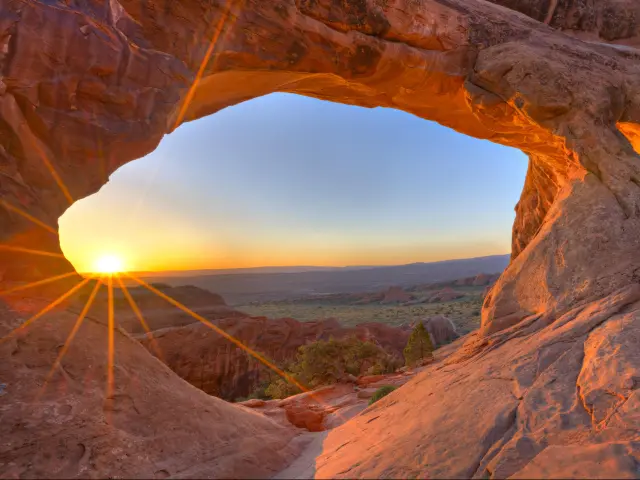
Devil's Garden
At the far end of the park road, Devil's Garden has the best collection of arches in one area. Landscape Arch is the showpiece - a 290-foot span of rock so thin it looks like it's about to snap. The trail to it is flat and easy, about 1.6 miles round trip.
Beyond Landscape Arch, the trail gets rougher - scrambling over rock fins and following cairns. Double O Arch and the Dark Angel spire are out here if you want to keep going. The full primitive loop is about 7 miles and takes most people 3-4 hours.
If you only have energy for one longer hike in Arches, do Devil's Garden rather than Delicate Arch. You'll see more arches in one walk than anywhere else in the park.
Fiery Furnace
A maze of narrow sandstone canyons tucked between towering rock fins. You can't just walk in - you either need a permit for self-guided entry or you book a ranger-led walk. The ranger tours sell out weeks ahead in peak season, so book through recreation.gov as early as you can.
It's a scramble, not a hike - squeezing through slots, climbing over ledges, and navigating without a marked trail. If that sounds appealing, it's one of the most memorable experiences in any national park. If it doesn't, skip it and spend the time at Devil's Garden instead.
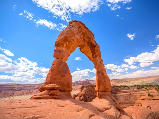
Delicate Arch
This is the one you've seen on every Utah license plate and every travel poster. The hike is 3 miles round trip and gains about 480 feet - not long, but the last mile is fully exposed slickrock with no shade and no water. In summer, the rock radiates heat and the trail can feel genuinely unpleasant by lunchtime.
So in summer, the smart move is to stop at Delicate Arch first on the way up, get it done in the cool of the morning, then drive to Devil's Garden and work your way back from there.
In spring and fall, the heat isn't a problem - save Delicate Arch for the way back down and start at Devil's Garden instead.
There's a lower viewpoint you can drive to if you don't want the hike, but it's a bit far and unsatisfying. The trail is the way to see the Arch close up.
The Windows and Double Arch
Halfway along the park road, the Windows section is the easiest stop in Arches. Short, flat trails lead to massive arches you can walk right up to. North Window, South Window, and Turret Arch are all within a few minutes of the parking lot, and Double Arch - two arches sharing the same wall - is just across the road.
This is the place to come in the afternoon when your legs are tired and the far end of the park is crowded.
Parking and entry
Arches dropped its timed-entry reservation system for 2026, so you no longer need to book a specific arrival window. Just show up during operating hours with your entrance pass.
That said, the parking problem hasn't gone away. Lots at Delicate Arch, Devil's Garden, and the Windows fill up by 9 or 10 AM on weekends and holidays. When a lot is full, rangers will temporarily close access to that section - you can't just circle and wait.
Buy the $55 Southeast Utah Parks Pass - it covers both Arches and Canyonlands and costs less than paying for each park separately. If you visit national parks anywhere else in the country, the $80 America the Beautiful pass covers everything for a year.
Canyonlands National Park
Canyonlands is the park most people underestimate. It's less famous than Arches, harder to photograph from a car window, and the name doesn't have the same ring. But it's a much bigger park and the views from the rim are on a completely different scale to anything at Arches.
The park is split into three separate districts that aren't connected by road. The most obvious place to start is Island in the Sky - it's 40 minutes from Moab, sits on a mesa 1,000 feet above the canyon floor, and every overlook feels like standing on the edge of the world.
Mesa Arch
The most photographed spot in the park. A short, flat trail - about half a mile round trip - leads to a small arch perched right on the cliff edge with the canyon dropping away beneath it. At sunrise, the underside of the arch glows orange from the reflected light below.
Get there before dawn if you want the shot without a crowd. By 30 minutes after sunrise, the overlook is packed and the moment is gone.
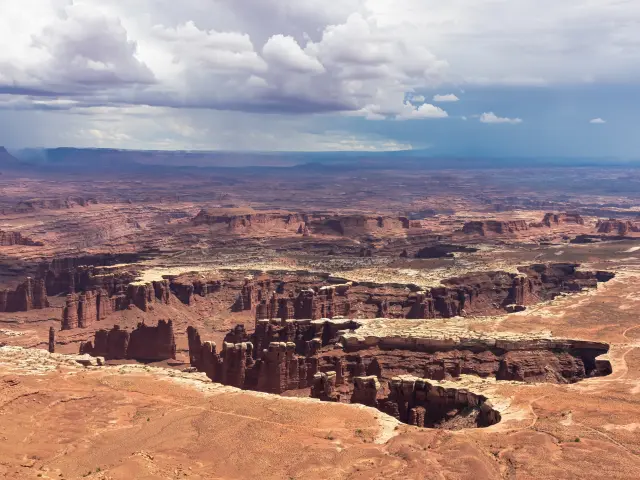
Grand View Point
At the very end of the road, 12 miles from the visitor center. This is the overlook that justifies the whole day - an unobstructed view across hundreds of miles of canyon, mesa, and desert stretching to the horizon. The Colorado and Green rivers carve through the landscape below you but they're so far down they look like scratches in the rock.
Walk the 2-mile round trip trail along the rim rather than just looking from the parking lot. Every few hundred yards opens up a slightly different angle and it never gets old.
Green River Overlook
Easy to miss because it's a short spur road off the main route, but don't skip it. The view down to the Green River and across to the White Rim is one of the best in the park and it's almost always quieter than Grand View Point.
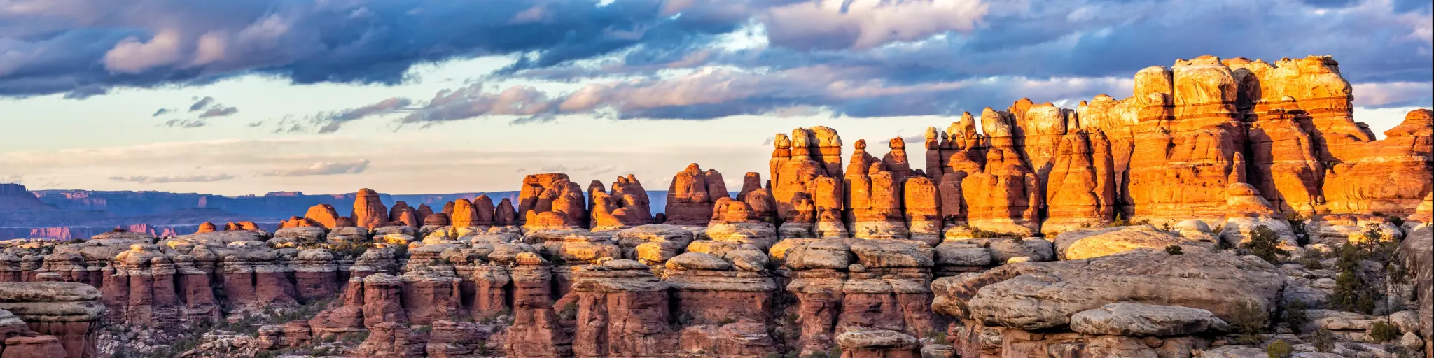
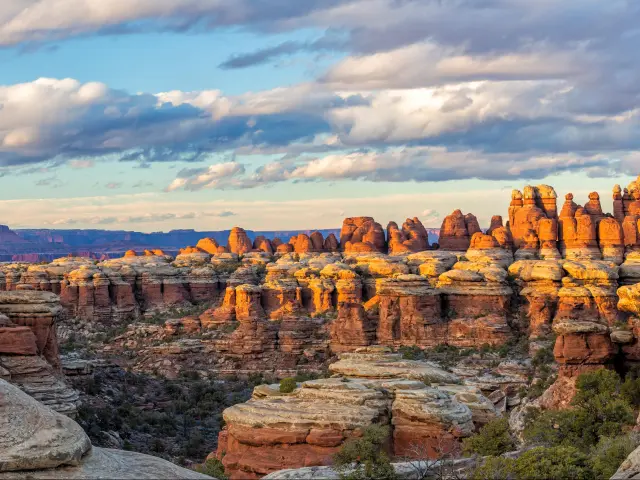
The Needles
The Needles district is 75 miles south of Moab - a completely different entrance and a completely different landscape. Instead of looking down into the canyons from above, you're walking through them, surrounded by red and white sandstone spires that give the district its name.
The trails here are longer and more remote than Island in the Sky. Chesler Park Loop is the most impressive - about 11 miles through open meadows ringed by rock spires.
Elephant Hill is the 4x4 road that gets the most attention. You can drive it, but you need genuine high-clearance 4WD and some off-road experience to attempt it. It's not a gravel road - it's rock ledges, steep grades, and tight switchbacks.
The Needles is a full extra day on top of a day spent at Island in the Sky. If you have the time, it's a completely different experience. If you don't, Island in the Sky is the one to go for.
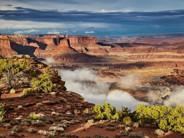
Dead Horse Point State Park
Dead Horse Point is a state park, not a national park, so your Southeast Utah Parks Pass won't work here - it's a separate $20 per vehicle. It's worth it though - the overlook is one of the best viewpoints in Utah and it takes about two hours to see properly.
The park sits on the same road as Canyonlands Island in the Sky - you'll pass the Dead Horse Point turnoff about 3 miles before the Canyonlands entrance on UT-313. The main overlook is a 2,000-foot vertical drop to the Colorado River, which bends in a slow gooseneck through the canyon below.
The East and West Rim trails loop from the visitor center out to the point and back - about 5.5 miles total if you do both. You don't need to do the full loop. The walk out to the point itself is about a mile each way on flat, easy trail, and that's where the view is.
Visit the park in the morning. The overlook faces roughly east, so the light on the canyon walls is best before midday. That leaves the afternoon free for exploring the river and Moab itself.
One thing worth knowing - the bright turquoise pools you'll see in the canyon below aren't natural. They're potash evaporation ponds from a mining operation.
They look surreal from 2,000 feet up and you might think they're some kind of geological feature, but they're man-made. Still makes for a striking view.
Beyond the parks
Moab isn't just a base for the national parks - there's a full day's worth of activities in and around town that have nothing to do with Arches or Canyonlands.
The Colorado River runs right through Moab, and an afternoon rafting trip is one of the best ways to see the canyon from a completely different angle. You've spent days looking down into the canyons from the rim - rafting puts you at the bottom looking up. You don't need any experience, but book a few days ahead in peak season.
Corona Arch is the hike the locals recommend when you ask what to do outside the parks. It's a 3-mile round trip to one of the most impressive arches in the area - bigger than most of what you'll see in Arches National Park - and it's completely free. No park entrance fee, no crowds, no parking problems. The trailhead is off Highway 279 along the river, about 20 minutes from town.
Moab is also one of the mountain biking capitals of the world. The Slickrock Trail is the famous one - 10 miles of riding across bare sandstone with views of the La Sal Mountains - but it's genuinely difficult and not for beginners.
If you haven't ridden slickrock before, the practice loop at the start of the trail will tell you within 10 minutes whether you're ready for the full thing. Bike shops in town rent bikes and can point you toward easier trails if Slickrock is too much.
If you'd rather drive than pedal, the Shafer Trail runs the long way down from Island in the Sky to the White Rim Road below, past Elvis Rock and all the way to Moab. It's one of the most dramatic 4x4 roads in Utah, but, again, you need high-clearance 4WD and steady nerves for the exposed switchbacks.
This trip combines well with:
If you're still deciding where to go, there's a lot of other road trip ideas in my Denver road trip guide - including trips to Zion and Grand Canyon or destinations in the Rockies.

Sasha Yanshin – Founder & Lead Driver
Sasha Yanshin has spent the last 15+ years mapping and driving thousands of miles across Europe and the US. As the Founder and Lead Driver of Lazytrips, he brings an analytical approach to road-tripping, sharing meticulously tested routes, realistic drive times, and the hard-earned logistical reality of the open road.
Read full bio