Road Trip from Phoenix to Moab
You could be in Moab in a day - it's only seven hours north if you keep your foot down. So if seeing Arches and Canyonlands over a long weekend is the goal, get in the car and you can be there by the afternoon.
If you have more time, Flagstaff and Monument Valley sit right on the way, and detours to the Grand Canyon or to Page for Antelope Canyon each add under two hours.
There aren't many routes that let you see this much along the way - the drive to Moab can end up more impressive than Moab itself.
The direct route is 470 miles and about 7 hours, driving past Flagstaff, and through Monument Valley before arriving in Moab.
🚙 EXPLORE MORE: The Best Road Trips From Phoenix
Read this before you leave Phoenix
🌡️ Desert Heat
Phoenix tops 110°F in summer and the high desert to the north isn't far behind. Stops and detours on this route - Horseshoe Bend, the Monument Valley loop, and the Moab trails - are fully exposed with no or little shade, so carry more water than you think you'll need and have backup water in the car.
⛽ The Reservation Gas Gap
Keep your tank full after Flagstaff. Gaps between gas stations become around 40 miles, and if one of those is shut unexpectedly, you will need to drive another 40 miles to the next one.
The last 50 miles along US-191 from Monticello to Moab has no gas stations at all, so top up more frequently than you would otherwise.
🕐 The Navajo Nation Clock Trap
Arizona doesn't do daylight saving time, but the Navajo Nation and Utah both do. So from mid-March to early November, the reservation and Moab run an hour ahead of Phoenix, which means the drive eats an hour you didn't plan for. Be careful not to be an hour late for your tour in Monument Valley or a restaurant reservation in Moab.
How many days do you need?
6 days is the minimum to do this properly, and 7 is perfect. Two of those are the drive up through Monument Valley; the rest give Moab enough room to take Arches and both halves of Canyonlands one at a time instead of cramming them.
Day 1: Phoenix to Monument Valley
🚗 320 miles ⏱️ 5 hours
Head up I-17 to Flagstaff - about two hours, climbing out of the desert into pine country at 7,000 feet. Fuel up and grab water here - it's the last big town before the long, empty run north across the Navajo Nation to Kayenta and Monument Valley.
The slower route up through Sedona and the red rocks adds 40 minutes of driving time, and at least another 3 hours if you want to stop for a hike.
Day 2: Monument Valley to Moab
🚗 150 miles ⏱️ 2 hours, 40 minutes
Catch sunrise over the mittens, then see the valley properly - drive the 17-mile loop yourself, or take a Navajo-guided tour into the backcountry you can't reach alone. Take your time - you won't have time for hiking in Moab when you arrive, so you're only aiming to get there in time for dinner.
Head north on US-163 and US-191 after lunch, stopping at Forrest Gump Point for the obligatory photo. Remember to keep your tank full as there are no gas stations after Monticello.
Day 3: Arches National Park
A full day in Arches, a few minutes from Moab. Drive to the far end of the park first and work back toward the entrance ahead of the crowds.
Do Delicate Arch early before the slickrock turns into a furnace, then Landscape Arch and the Windows. Lots fill by mid-morning on weekends, so the earlier you're through the gate the better.
Day 4: Canyonlands - Island in the Sky
The mesa-top district is 40 minutes from Moab and a thousand feet above the canyon floor. Mesa Arch at sunrise is the classic shot if you can get up early for a third day in a row. Otherwise, there's no rush - Canyonlands does not get full like Arches and you won't be turned away at the gate.
Grand View Point at the end of the road is the one that stops you cold: canyon and mesa to the horizon in every direction. Walk the rim trail to see a lot more than the view from the parking lot.
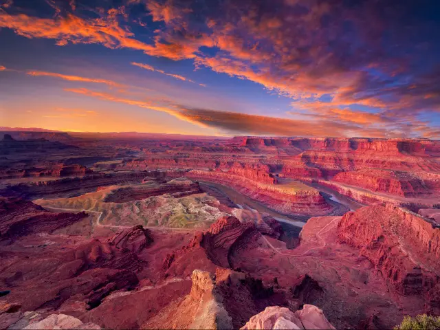
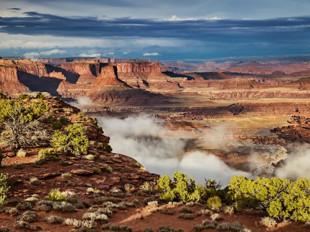
Day 5: Dead Horse Point & the Colorado River
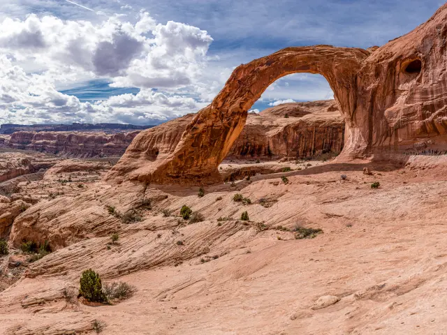
Dead Horse Point has a 2,000-foot drop to a gooseneck in the Colorado, best in the morning light. Spend the afternoon down on the river itself - a rafting trip, or the easy hike out to Corona Arch, a span bigger than most inside the national park. After days of looking down into canyons, the river puts you at the bottom looking up.
Optional Extra Day
The Needles
This is the southern district of Canyonlands, about 90 minutes south of Moab - your chance to get in among the rock spires and canyons on foot, instead of looking down from the rim like on Day 4.
It's further out, so there are fewer people and more hiking; trails like the Chesler Park loop are great for a bonus day of exploration.
Day 6: Drive back to Phoenix
🚗 470 miles ⏱️ 7 hours
It's a long drive home - 7 hours before any stops or delays. Google Maps will offer an alternative via Holbrook that adds an hour and isn't any more scenic, so reversing your route makes the most sense.
If you're short on time, drive straight through Monument Valley with no overnight stop, then skip the Needles day and Dead Horse Point - you'll still see Arches and Canyonlands over a 4-day road trip.
The route from Phoenix
If you want to plan your own stops or reroute via Vegas, you can build your own trip in the Planner
The drive itself is simple: Take I-17 north from Phoenix to Flagstaff, US-89 and US-160 across the Navajo Nation to Kayenta, then US-163 up through Monument Valley and US-191 into Moab.
Stop for snacks in Flagstaff - shops become few and far between afterwards and gas stations appear every 40 miles or so.
You'll see the towering red rocks of Monument Valley just after you pass Kayenta.
From Monument Valley it's an easy run into Moab - under 3 hours, straightforward the whole way.
If time is on your hands, Goosenecks State Park just after Mexican Hat has amazing views of u-bends in the San Juan River. The road goes right up to where the views are, so it won't take much time out of your day.
Wilson Arch is 25 miles before you get to Moab - you can't miss it, as it's just off the highway on your right. Another place to stretch your legs without a big time drain.
Where to stay
The View in Monument Valley
There are only 2 hotels in the area and a few campsites, so you don't exactly have a lot of choice.
One of these two is much closer to the buttes and every room has a private balcony pointed straight at the Mittens, so you get sunset and sunrise over the most famous rock formation in America from your own bed.
That's The View Hotel and you can only book it direct. Remember to book well in advance as the hotel can sell out in peak season.
Just to manage your expectations - the rooms are basic, the food gets middling reviews, there's no pool and no alcohol (Navajo Nation rules).
For one night, none of that really matters - you're there quite literally for the view, and nowhere else on earth gives you this one.
Red Cliffs Lodge in Moab
Most people book on Main Street, walking distance to dinner and minutes from the Arches entrance. That's fine, but you're missing out on the full experience.
Red Cliffs Lodge is a riverside ranch resort that sits right on the Colorado River, 14 miles outside Moab on Highway 128, with red cliff walls rising on both sides, the Milky Way overhead at night and horses in the paddock by morning.
The trade-off is you're 20 minutes from the Arches entrance and you'll want a designated driver if you eat in town. But that's about it except for an oddly steep $20 parking charge at the hotel in the middle of nowhere.
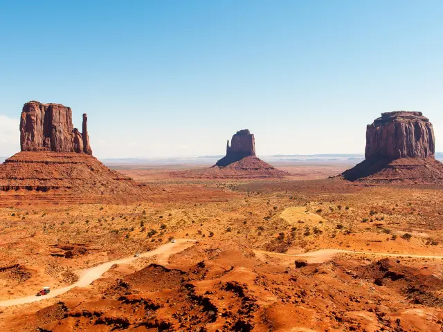
Exploring Monument Valley
You've probably seen Monument Valley a hundred times - John Ford shot so many Westerns among these buttes that they became the visual shorthand for the American frontier. There are three ways to see them up close and you should consider doing all 3!
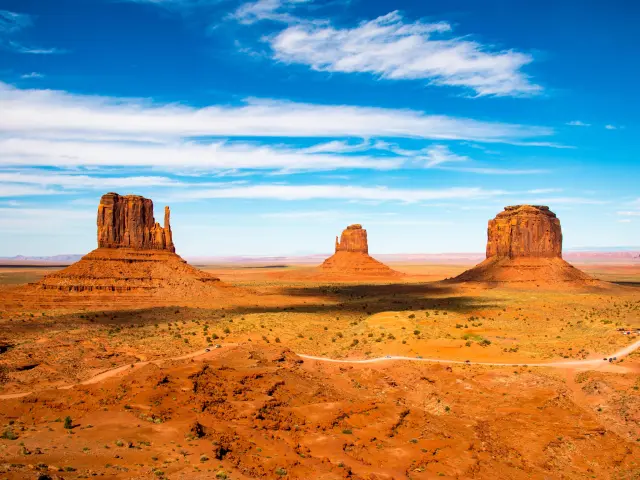
The 17-mile loop
You can drive the scenic loop yourself, at your own pace. It's an unpaved road that drops down among the buttes past the classic viewpoints and should take about two hours with photo stops.
The road is rough, uneven and sandy in patches. You should be fine with an SUV or in a truck and a normal car will manage in dry weather if you go slowly, but it's at your own risk, and after rain it can be a struggle. Motorcycles and RVs are not allowed in.
Last entry in the summer is 4:30 PM (2:30 PM in the winter), so if you want to do the drive on arrival, make sure you leave Phoenix early enough.
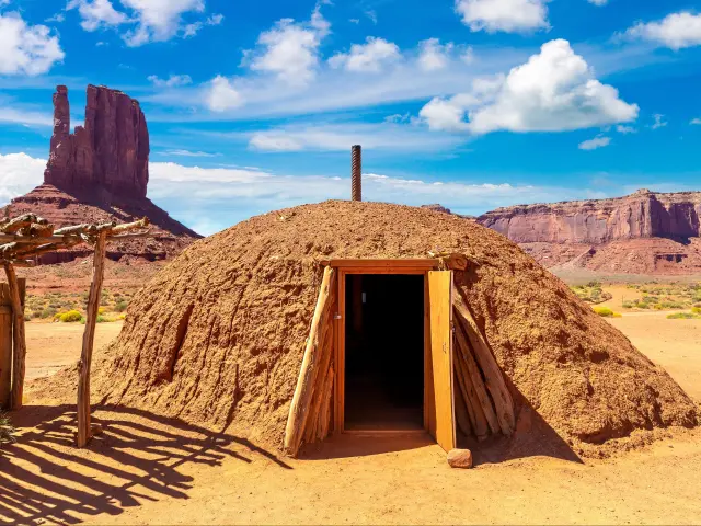
A Navajo-guided tour
A guide gets you where the loop can't. Roughly half the park is backcountry closed to anyone driving themselves - the arches, the petroglyphs, Mystery Valley - and you can only go in with a Navajo guide.
There are a few different operators and a typical 4x4 tour runs around $85 per person for a couple of hours, usually with a stop at a hogan and some local lore from the guide.
Some of the providers even offer the tour on horseback if you're wanting the authentic way to get around here.
On foot - Wildcat Trail
The 3.2-mile trail starts at The View Hotel and does a loop around the nearest of the 3 buttes.
It's a pretty simple hike - there's no real climbs up or down and it takes around 2 hours to do the loop. The only things you need are a camera and water.
Costs and Opening hours
The park currently charges $10 per person per day and another $15 for your car - you're on Navajo tribal land, so your US national park pass won't work here.
The park is generally only open during daytime hours and that's a catch if you don't stay at The View because you can't be in the park at sunrise or sunset unless you're staying there.
Detour options: Grand Canyon & Page
Both of these are off the main route and will add a fair bit of time to your drive.
It's tempting to do these detours without adding an extra night - they are only a couple hours of extra driving.
But the truth is - if you're driving 7 hours on Day 1, you're not giving yourself much time to see the Grand Canyon and all you're doing is ticking the box of having "been there".
So I'd recommend going there with an extra night's stop, or heading straight to Monument Valley and taking the 2-hour hike in the afternoon instead.
Grand Canyon
If you want to do the full Grand Canyon experience, driving in through the South Entrance is the faster way from Phoenix.
The Vegas crowds will get there before you, so you'll miss the worst traffic at the entrance.
Photos from the top are one thing, but hiking into the valley is where it's really at - you can spend a few hours taking the shuttle or hiking along Hermit Road, or, if you're up for a big challenge, take the 2+ day trip down to the Colorado River at the bottom.
If you really don't want to stop over, you can get a glimpse of the Canyon from Desert View which is a viewing point just after the East Entrance to the park - half an hour's drive from Cameron.
So if you must see the canyon on your way, but don't want to stop, this is the way to do it.
Remember that Grand Canyon is a national park, so the standard entrance fee applies even if you just want to make a quick stop on the way.
Page: Antelope Canyon & Horseshoe Bend
Page sits about 80 miles north of Cameron on US-89, and unlike the Grand Canyon quick-glimpse, this one genuinely needs an extra night.
Antelope Canyon is why it's worth making the drive - you can walk through narrow slot canyons with light beams cutting through the sandstone.
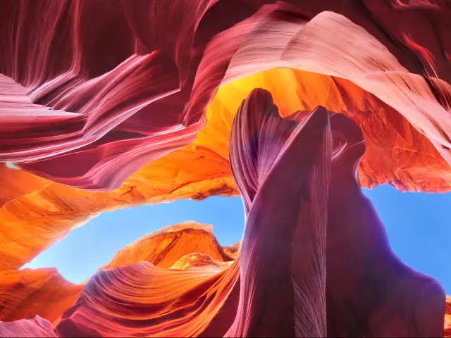
But, like with Monument Valley, it's Navajo land, so you have to book guided tours and the popular ones sell out weeks ahead in peak season.
The tours take a couple of hours and you need to be there for your booked slot, so turning up and doing a tour after a whole day of driving is not a great idea.
Horseshoe Bend is the opposite - no booking is needed, the cost is just a $10 parking fee, and the rim is just a short walk from the parking lot for one of the most photographed viewpoints in the Southwest.
It's a must stop if you're already in Page for Antelope Canyon, but maybe not worth the 80-mile detour just for 20 minutes of taking in the view.
The way to do this detour is - book your Antelope Canyon tour and a night in Page before you come.
When you arrive in the afternoon, take a scenic drive along US-89A to see the Vermilion Cliffs as the sun goes down before dinner. In the morning do your Antelope Canyon tour and then drive the 2 hours to Monument Valley after lunch.
For fellow math nerds, the road to Page is US-89 and the way back to Monument Valley is the reverse: US-98.
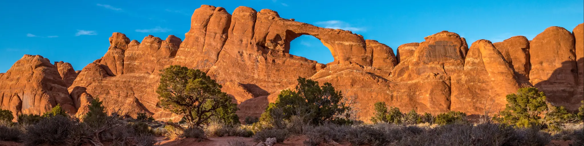
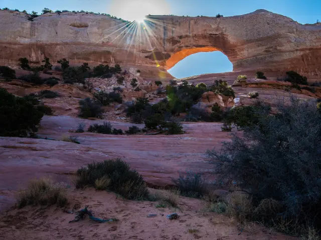
Arches National Park
Arches is five minutes from Moab and the main reason most people come to visit. Over 2,000 natural stone arches packed into a park you can see in a day.
The timed entry reservation that ran for the last few years has been dropped in 2026, so you can show up without pre-booking.
But the park's popularity hasn't gone anywhere - parking lots at the popular trailheads fill by mid-morning on weekends, and if the park hits capacity they'll close the entrance until people leave. Get there early.
The park has one road in and out, ending at Devils Garden 18 miles from the entrance. Drive straight to the far end first, then work your way back. Most visitors start from the front of the park as soon as they see the signs, so you'll be doing the reverse.
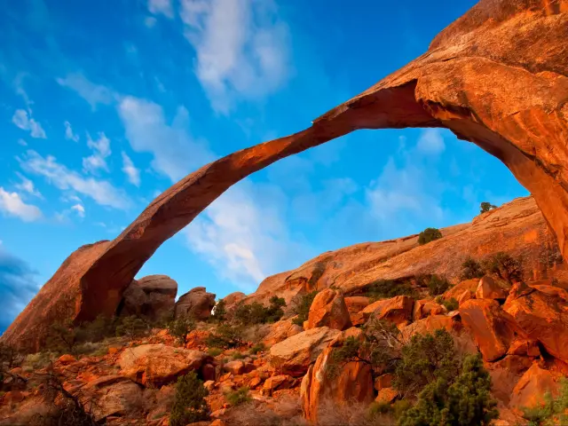
Landscape Arch in Devils Garden is the longest arch in the park - a razor-thin span that looks like it shouldn't still be standing. The walk to it is flat and easy. If you want more, the primitive loop trail beyond it leads to more arches with far fewer people, but the trail gets rougher.
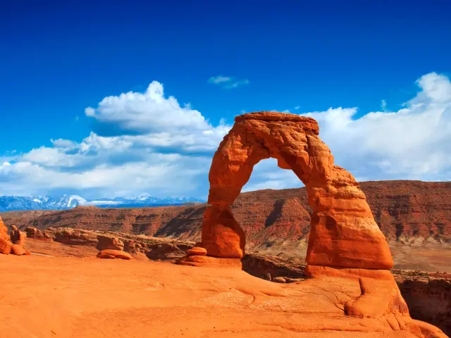
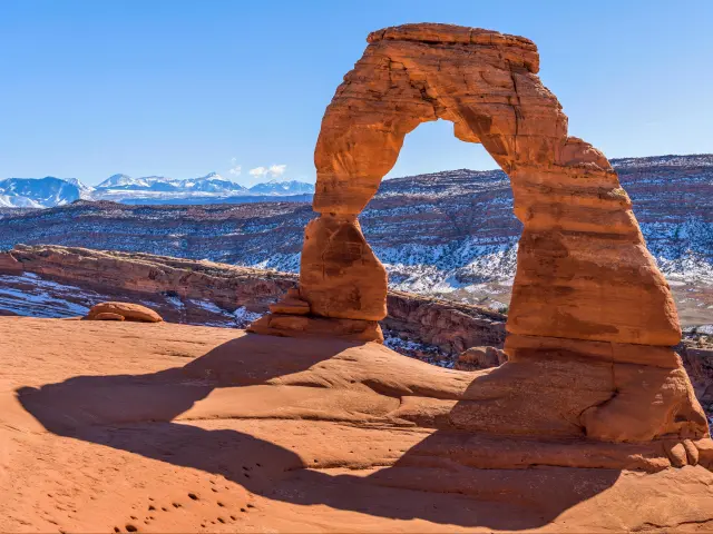
Delicate Arch is the one you've seen on the photos - the freestanding arch on every Utah license plate.
The hike to it is a 3-mile round trip on exposed slickrock with no shade, but it's towards the back of the park, so you can see it before the sun gets hot. The trail is straightforward but it's all uphill on the way there, so bring plenty of water.
The Windows and Double Arch are both easy stops with short walks and Balanced Rock is a photo stop right off the road.
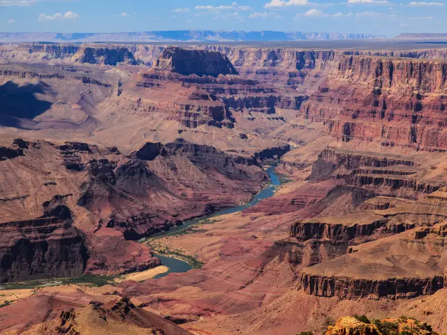
Canyonlands National Park
Parks in this part of Utah have pretty self-explanatory names. Arches is about the arches and Canyonlands... Well... It's not the arches.
The canyons here were carved by the Green and Colorado rivers and stretch to the horizon in every direction.
Island in the Sky
The northern district is the closer one to Moab - about 40 minutes' drive.
This part of the park sits on a mesa a thousand feet above the canyon floor. The whole visit is viewpoints, and every one of them is worth the stop.
Mesa Arch is the classic sunrise shot - a short walk to a small arch that frames the canyon and the La Sal Mountains as the first light comes through. Get there before the photographers fill the ledge.
Grand View Point at the end of the road is the big one. The canyon drops away on three sides and the view just keeps going. Walk the rim trail rather than just looking from the parking lot - two miles along the edge, and you'll have most of it to yourself.
Green River Overlook is the other one worth a stop - it's easy to spend a while watching the river at the bottom of the canyon.
You'll notice that Canyonlands is a lot quieter than Arches. You won't queue at the gate and you won't fight for parking - turn up when you want and do what you like.
If you have a 4x4 or a truck, there are some very scenic (but very rough) roads that go around the perimeter of the park.
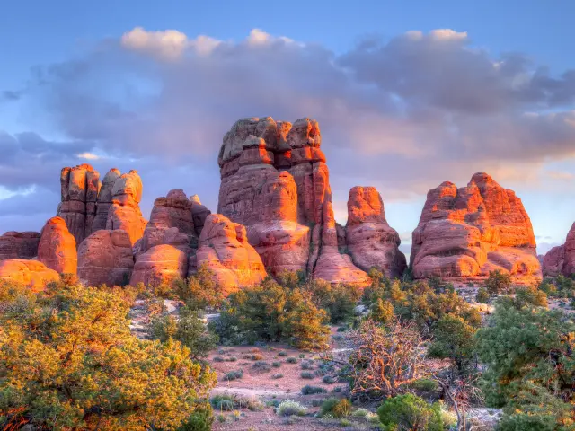
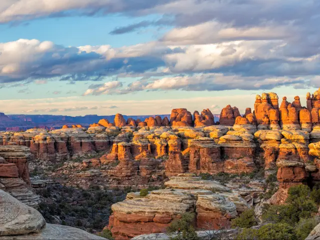
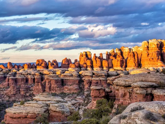
The Needles
If you opt for the bonus day, the southern district is a completely different park. It's about 90 minutes south of Moab, and instead of looking down from a mesa, you're hiking in among the rock spires and canyons at ground level.
It's further out, so there are far fewer people. The point here is to hike the trails like the Chesler Park loop - you don't get the big views, but you do get close and personal with the landscape.
Beyond the parks
Arches and Canyonlands are the main event when you come to Moab, but there is a lot more to see here beyond the national parks that many visitors ignore and miss out on.
It's worth taking a day to spend outside the parks, and after 2 days of hiking, it's fun to do something a little bit different for variety - I'd do Dead Horse Point and kayaking over The Needles if you have to pick one.
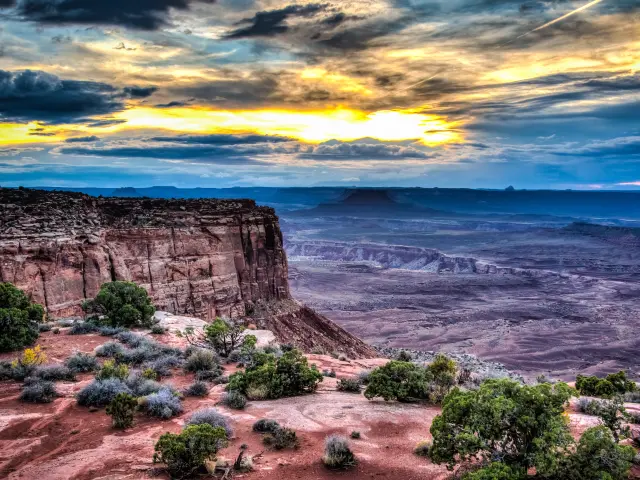
Dead Horse Point
Dead Horse Point is a turn off the same road that takes you to Island in the Sky just before you get to the park entrance. It's a state park with a 2,000-foot drop to a gooseneck in the Colorado River, and the views rival the bigger park next door.
You get a very different perspective here looking down a steep river bend canyon framed by sheer cliffs.
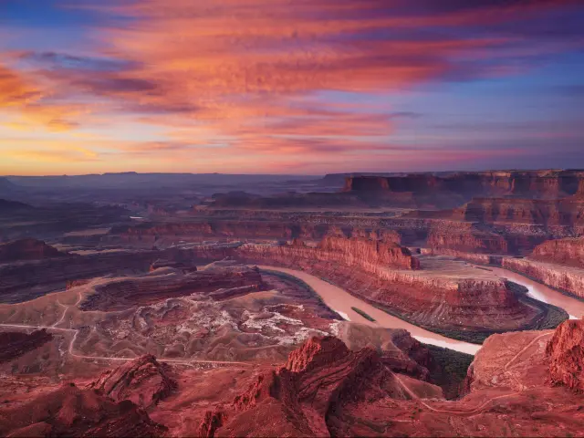
You can walk the rim trail to get better views than just the snapshot from the parking lot - the view changes every few hundred yards along the edge.
Getting on the river
After days of staring down into canyons, the river is where you flip it. You can spend half a day going down a calm stretch of the river near Moab - no experience necessary and you can set it up via one of a number of outfitters on Main Street.
If you'd rather go for another hike, the trail to Corona Arch starts on Potash Road just outside town. It's about a 3-mile round trip with a section of cables and a ladder on the slickrock, which is a longer and more challenging hike than many of the ones inside the national parks.
There's no fee to enter, and no crowds either which makes it a very compelling option.
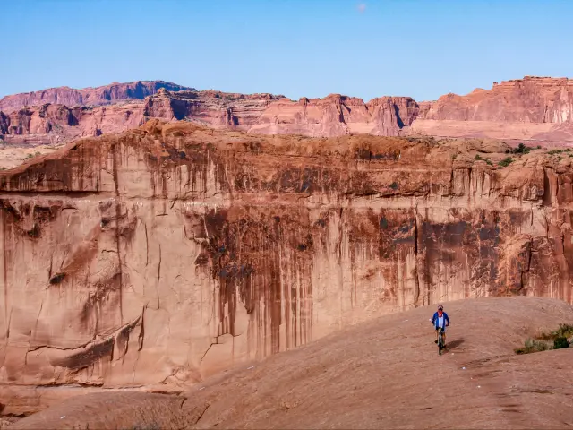
If you ride bikes, you probably already know that Moab is one of the best mountain biking destinations in the world. The Slickrock Trail is the famous one - 10 miles on pure sandstone.
One last tip - book dinner reservations in Moab in peak season - the restaurants fill up fast and without a reservation, you'll have to wait.
This trip combines well with:
If you're still choosing where to go, there are other road trip routes in my Phoenix road trip guide - including detailed trips to Grand Canyon and Page if you want more detail on those.

Sasha Yanshin – Founder & Lead Driver
Sasha Yanshin has spent the last 15+ years mapping and driving thousands of miles across Europe and the US. As the Founder and Lead Driver of Lazytrips, he brings an analytical approach to road-tripping, sharing meticulously tested routes, realistic drive times, and the hard-earned logistical reality of the open road.
Read full bio