10 Best Scenic Drives in Arizona
Did you know that you can see Arizona's famous red sandstone desert, Ponderosa pine forests and iconic Grand Canyon's stunning views directly from the seat of your car? Arizona is a state of dramatic landscapes, and there are so many scenic drives you can take to admire its majestic sights.
Looking for a more historic focus for your sightseeing? Try driving along Route 88 and experience the Apache Trail or get your fix of American pop culture along historic Route 66. Or explore Arizona's colonial history with a drive through stunning Patagonia in the southeast of the state.
Arizona is a playground for outdoor adventurists with its out-of-this-world landscapes. There are numerous scenic drives you can take to admire Arizona's unique scenery, from short adventures to stunning desert experiences well worth the effort.
We've got you covered no matter what kind of drive you are looking for. Read on to find out about the best scenic drives in Arizona and how to enjoy them to the fullest with our tips.
| Road trip | Rating |
|---|---|
| 1. Red Rock Scenic Byway 10 miles, 30 minutes | Easy |
| 2. Monument Valley Scenic Drive 10 miles, 40 minutes | Easy |
| 3. The Grand Canyon North Rim Scenic Drive 20 miles, 40 minutes | Easy |
| 4. Sky Island Scenic Byway 25 miles, 45 minutes | Moderate |
| 5. The Grand Canyon South Rim Scenic Drive 30 miles, 50 minutes | Easy |
| 6. Apache Trail Historic Road 40 miles, 2 hours | Ambitious |
| 7. Patagonia-Sonoita Scenic Road 80 miles, 1 hours 30 minutes | Easy |
| 8. Arizona's White Mountains 100 miles, 2 hours 20 minutes | Moderate |
| 9. Fredonia-Vermilion Cliffs Scenic Road 110 miles, 2 hours | Moderate |
| 10. Historic Route 66 280 miles, 4 hours | Easy |
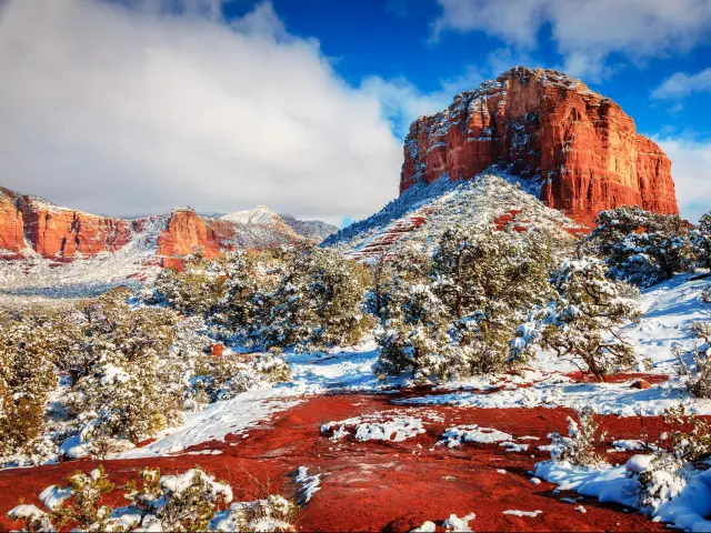
1. Red Rock Scenic Byway
10 miles (30 minutes)
Near Sedona
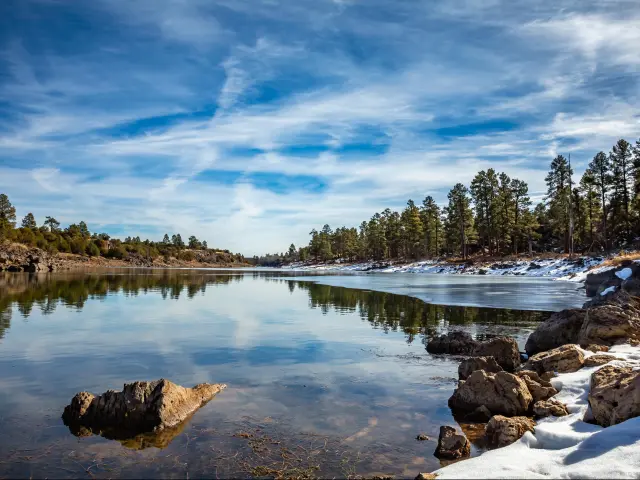
What makes this scenic drive special: The landscape along the Red Rock Scenic Byway is characterized by red rock sediment. What makes it stand out is the layered pattern in the rock features, made by millions of years of sand being packed together by natural forces.
This layering is best observed at Cathedral Rock, a cliff-like rock formation that is a popular destination with hikers and spiritualists, drawn to the beautiful and ethereal quality of the land.
The Red Rock Scenic Byway is sure to be one of the most unique landscapes you have ever driven through, allowing you to experience Arizona's beauty from a different vantage point than the more traditionally traveled Grand Canyon.
It is a relatively short drive with lots of things to stop and see along the way, so you can easily make this a fun day-long road trip.
How to get there: Like many of the scenic drives on this list, the Red Rock Scenic Byway follows a simple, straightforward route. You won't have any trouble following Route 179 S the entire drive from Sedona to the Red Rock Scenic Byway Sign.
On the way, you will pass through the Village of Oak Creek, which is a fun place to stop and explore.
Scenic stops/overlooks:
- Red Rock Ranger District Visitor Center — You may think a visitor's center offers nothing more than help to plan your trip, but you'd be wrong about this one. Inside are exhibits like a red rock geography exposition, a timeline of human history in the Verde Valley, and an interactive display of the seven main biology communities inhabiting the area. And don't miss the beautiful garden made entirely of the valley's native flora.
- Village of Oak Creek — About three-fourths of the way through your drive, you'll pass through this fun small village that makes a great place to stop and rest. Surrounded by the Coconino National Forest on the east and west, the town also offers great unimpeded views of Bell Rock and Courthouse Butte.
- Chapel of the Holy Cross & Cathedral Rock — This isolated church is perched high on a cliff face, its single tower reaching 250 feet into the sky. From the top of the tower you will see Cathedral Rock dominating the landscape in the distance. Its striped cliff face is one of the most iconic visuals of the red rock desert, and it is sure to leave you in awe.
- Bell Rock — You will easily spot this massive butte because it is uniquely shaped compared to the more common flat-topped buttes of the area. It is also a well-known energy vortex site.
- Courthouse Butte — To the east of Bell Rock you will see Courthouse Butte. Its abnormal shape is formed by the stacked layers of the main butte and the wavy cliff leading to a smaller peak at its side. Both Bell Rock and Courthouse Butte are impossible to miss, as they burst onto the landscape as you approach the Village of Oak Creek.
Our highlights: The drive itself is stunning, passing by many desert viewpoints and rock landmarks. But there are also fun things to stop and see along the way besides the beautiful Arizona desert.
The Tlaquepaque Arts & Shopping Village is a unique experience that you absolutely must stop and see. It is located just outside Sedona and offers impressive shopping for locally made souvenirs and crafts.
The walkable shopping district was modeled after a Mexican village and showcases more than 50 shops, art galleries, and artisans.
In our opinion, the Chapel of the Holy Cross is the ultimate bucket list item along this route. You cannot miss visiting this lonely chapel, which was built into the cliff face and offers breathtaking views of the landscape from high above.
The spire of the church stands 250 feet up from the thousand-foot-high cliff face. It gets its name because from its vantage point, you get a clear view of Cathedral Rock.
Want to explore off the beaten path? Munds Mountain Wilderness is a spectacular detour to take from the Village of Oak Creek. It includes over 18,000 acres of forest that features stunning cliff faces and views of red rock mesas.
You have to hike the area for the best experience, especially if you want a view of Arizona's highest mountain, San Francisco Peak.
Where to stay: With so many sites to see along the Red Rock Scenic Byway, you can easily stretch this short drive into a day-long road trip. Seeing the same views on the drive back up to Sedona from the opposite perspective will add to the magic of the trip.
It's a good idea to stay at least one night at a hotel on your way back to Sedona. We recommend The Cozy Cactus, conveniently located in the Village of Oak Creek.
Like the village, the hotel is nestled in Coconino National Forest and each room offers stunning views of the desert. Over 360 miles of hiking trails start from the Cozy Cactus, perfect for those who like to stretch their legs after a long drive.
This quaint and comfortable lodging with great views of the national forest and red desert makes for the perfect stay along the Red Rock Byway.
Bonus: You might feel extra spiritually uplifted after visiting Cathedral Rock, and that's not just because of its name. The rock is known as one of the most intense energy vortexes in the area. It is one of the four most popular vortexes, including Bell Rock, Airport Mesa, and Boynton Canyon.
Sedona is said to contain seven energy vortexes—sites where the earth's energy radiates through you and promotes wellbeing on a meditative, physical, and spiritual level.
Cathedral Rock has a reputation of being the most powerful, with visitors reporting being overcome with a strong sense of calm and introspection. Visiting the Cathedral and gazing out at Cathedral rock from its summit only intensifies the experience.
Our travel tips: The Chapel of the Holy Cross might be isolated on a cliff edge, but it is still a working chapel open 9am-5pm every day, with services taking place throughout the week.
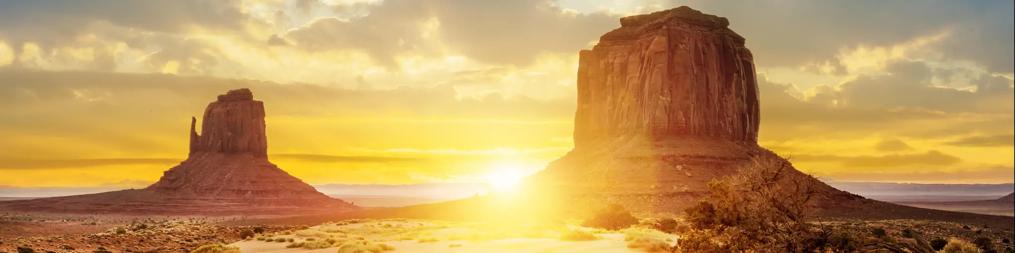
2. Monument Valley Scenic Drive
10 miles (40 minutes)
Near Oljato
What makes this scenic drive special: One of the most popular and most recognizable landscapes in Arizona after the Grand Canyon, Monument Valley has been featured in countless movies and tv shows, showing off the beautiful red sandstone and arid terrain. There is no place like it in all the American Southwest.
The Monument Valley scenic drive will take you past towering rock spires, craggy cliffs, and massive mesas. We will point out all the famous landmarks, as well as the best viewpoints where you can stop and gaze at vistas that will take your breath away.
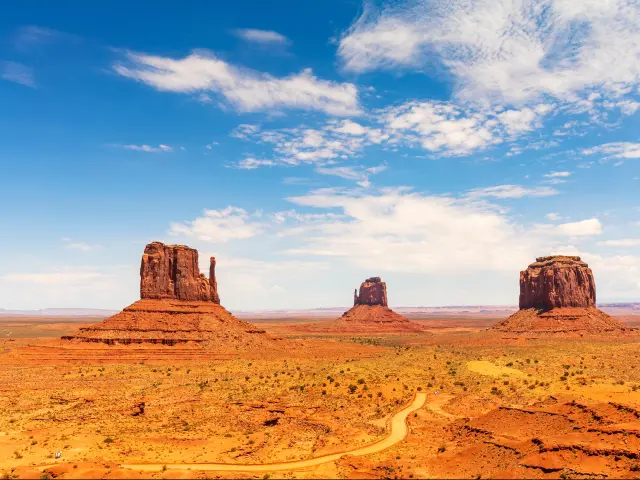
How to get there: Located on Arizona's northern border with Utah, the Monument Valley Scenic Drive takes the form of a loop that brings you by various natural rock formations and landscape viewpoints, with two short detours off the main route to reach the famous John Ford's Point, the Mittens, and Merrick's Butte.
Begin at Monument Valley Tribal Park Visitor Center and go north up Monument Valley Road. Drive along Indian Route 42 going East and then loop around and come back west along the same highway.
Scenic stops/overlooks:
- The Mittens — Also called the East and West Buttes, these two whimsical rock formations mirror one another from a short distance of 1.5 miles. The towers eroded uniquely over time to look like a pair of mittens, with thin spires of rock representing the thumbs.
- Merrick's Butte — This flat-topped tower of shale and sandstone is majestic in the background of nearly every image of Monument Valley.
- The Three Sisters — Made from thousands of years of erosion, the three sisters are a trio of extremely thin towers breaking off the wider Mitchel Mesa. It is a very cool site to see, with the needle-thin middle sister huddled between the relatively thicker sisters.
- John Ford's Point — See through the eyes of director John Ford when he shot this panoramic vista across Monument Valley for his classic Western films. It takes bravery to stand on the high cliff edge and look out over the valley, but you will be rewarded with jaw-dropping views of craggy rock formations and impossibly tall and flat-topped buttes.
- Artist's Point — This is a colorful viewpoint from which you can gaze out at the long stretch of Monument Valley, earning its name from the countless photographers and artists who favored this lookout point. The light of the sun brings out the various colors in the otherwise red landscape, and you might want to time your visit with the sunrise to see the full palette of colors.
- The Cube — A truly unique rock located at the base of the driving loop, the aptly named cubic rock looks like it was carved to purposely look like it has six sides.
Our highlights: There is no place on earth like the Arizona desert, with its red landscape and otherworldly rock formations that can be found nowhere else on the globe. The landscape looks alien and majestic with its unique color and various buttes and rock spires reaching into the sky.
One of the most iconic sites in the valley is the view of the Mittens. Their eccentric shape has made them into famous symbols of the Arizona desert. These two rock formations jutting out from the earth like twins have captivated viewers for years.
There are a handful of sites that are only accessible via guided tour, but they are certainly worthwhile additions to your visit. We think it would be a shame to leave Monument Valley without a glimpse of these stunning sights.
The Ear of the Wind is a breathtaking natural formation of a wide peephole straight through a blanket of sandstone known as the DeChelly Rock. It was formed by natural rock erosion, but it is easy to imagine that the wind blew right through the rock to create it.
The Totem Pole is all that's left of an ancient butte eroded to nothing but a thin spire that reaches up toward the sun. It's located near other rock formations of interest like the Yei be Chei and the Hunts Mesa, both of which are also viewable when seeing the Totem Pole.
If you want to be extra adventurous, take a break from driving and set out along the popular Wildcat Trail. Go on foot or on horseback along the nearly four-mile-long trail that takes you to the most popular sites in Monument Valley. The unpaved but well-worn dirt trail is marked for easy traversing.
There are many souvenir stands dotted around the visitor's center where you can purchase Navajo arts and crafts.
Where to stay: Guided tours of the valley include special access to sites such as Ear of the Wind and the Totem Pole. This is why it is useful to stay at least one night at Monument Valley so that you can drive the loop one day and take a guided tour of the southern sites the next day.
Goulding's Lodge is the perfect place to stay to get the most out of your trip to Monument Valley. You won't get enough of the stunning mountain views during your stay here.
Head to the fabulous indoor pool to stretch and relax after your drive or for an energizing dip before you head to Monument Valley. Before heading out, we recommend making a reservation at the hotel's fantastic restaurant so that you can have a delicious meal after your adventures.
Bonus: Monument Valley became a famous landmark in mainstream America when it was featured in the classic John Ford cowboy films Stagecoach and Rio Grande. Westerns made it a popular tourist spot during a time when it was only well known to the Navajo people who lived on the land.
John Ford's point is an iconic site today not only because it offers a stunning view of the desert landscape, but because he often used shots of the rock formation in his films.
The valley continues to be used in movies today, notably in Forrest Gump and 2001: A Space Odyssey, and most recently on the show Westworld.
Our travel tips: A popular time for tourists falls between the months of April and September when the valley is flooded with sightseers, hikers, campers, and adventurists.
There is a winter season as well from October to December when the weather is more temperate. You may want to go during this time if you prefer it to be less crowded.
The scenic drive is open from 8am to 5pm and costs $8 to enter (at the time of writing).
The unpaved road is mostly made of dirt and gravel, but it is well-marked with signage pointing out the various sites of interest. Since the road forms a loop with no way to get lost or go off-trail, it should be an easy drive for most visitors.
3. The Grand Canyon North Rim Scenic Drive
20 miles (40 minutes)
Near Jacob Lake
What makes this scenic drive special: This short but incredibly scenic drive gives you great views of the Grand Canyon from the North Rim. There is more greenery and forest along this route than along Desert View Drive, and you will get a very different experience of the canyon.
Because of the seasonality of this road, this drive is also less crowded than the desert side of the canyon. The North Rim generally receives fewer visitors than the South Rim, which will mean easier photo ops without having to wait!
How to get there: Start at Bright Angel's Point, located further down from the Grand Canyon Lodge. Follow route 67 North until you reach Fuller Canyon. From there you turn right onto Cape Royal Road.
Follow this paved road until you see a turn to the left which leads to Point Imperial, your first detour. This road is aptly called Point Imperial Road, which is also seasonal.
Once you see the site and come back down onto Cape Royal Road, you will follow this winding road all the way to Angel's Window.
Scenic stops/overlooks:
- Bright Angel Point — South of Grand Canyon Lodge, this overlook gives a wide expanse view of the canyon from east to west. It is the most popular view of the canyon from the North Rim.
- Coconino Overlook — A breathtaking view of the Grand Canyon with its cliffs rising between a frame of aspen trees.
- Vista Encantada – A tranquil spot for a picnic and a rest among the Ponderosa pines, with views of the canyon all around.
- Roosevelt Point Overlook — It is said that when President Roosevelt looked upon the Grand Canyon from this viewpoint in 1903, he proclaimed that “the ages have been at work on it” in reverence to its epic beauty and was inspired to recognize the canyon as a national landmark.
- Walhalla Overlook - This lookout point is surrounded by the high cliffs of the canyon, with views of the valley spreading out below them. The site of 1,000-year-old Puebloan ruins is just a quick walk away.
- Angel's Window — Look through the arch of Angel's Window and you'll see why the name fits. The striped cliff looks almost pink and you can see straight through a massive arched peephole eroded into the stone.
- Point Imperial — At an elevation of 8,803 ft, this is the highest point on the North Rim and overlooks the east of the Grand Canyon. It's so high up that you can spot the Painted Desert and Marble Canyon in the distance.
- Cape Royal - A good rest stop with restrooms, parking, and a picnic area, this overlook boasts views of the Colorado River, which are more rare along the North Rim. You can also catch great sunsets and sunrises from here.
Our highlights: In general, the North Rim is a quieter experience than the south of the canyon, with fewer crowds and a lot of hiking trails and picnic areas. The South Rim tends to be more popular with tourists solely for the fact that it is more developed and caters to visitors more.
The North Rim's seasonality makes it a more challenging visit, especially with the scenic road closed in the winter months all the way from October to May.
Still, the North Rim offers its own beautiful views of the Grand Canyon from various lookout points highlighted above. It has its own charm, mainly its peaceful ambiance.
Make sure you save some sightseeing for nighttime when the skies will be lit by starlight. It is a rare opportunity to see thousands of stars without the obstruction of pollution. We recommend doing some stargazing and appreciating the night sky.
Where to stay: The North Rim has fewer accommodation options nearby when compared to the South Rim. Though it is a short drive away, we recommend making Kanab your base as you explore this fascinating world-wonder and stay at Red Canyon Cabins.
These rustic cabins have a shared barbecue area so you can enjoy a delicious meal once you have finished exploring the stunning vistas of the Grand Canyon in the homey comfort that is hard to find in most accommodation options.
Fun facts: From Point Imperial, you can get a glimpse of the Milky Way if you go early, it usually appears during sunrise. It is a popular spot for photographers to snap pictures of the stars in the sky because of the great astronomical view.
Our travel tips: This is a seasonal option as the road is not open October-May, so you should plan your trip accordingly. If you go in September, you may catch the beginning of fall foliage and leaves changing on the Aspen trees, making it a unique and beautiful experience.
The vehicle entrance fee to the North Rim is $35 and remains valid for one week. Pay fees at the North Rim Visitor's Center (closed in the winter), located near Grand Canyon Lodge.
As mentioned, the North Rim is generally not accessible during the winter and reopens to visitors annually on May 15. It closes again on Oct 15. Even though roads on the scenic drive are paved, we recommend checking with the visitor's center in case weather closures are in place.
4. Sky Island Scenic Byway
25 miles (45 minutes)
Near Tucson
What makes this scenic drive special: A desert-to-forest journey, the Sky Island Scenic Byway is a must for any nature lover and adventurer. Starting outside Tucson, this will bring you along the Catalina Highway through the Coronado National Forest.
It is a relatively short drive, but there is a whole lot to see along the way. The landscape changes the higher you go, from a dry terrain that recalls the traditional Arizona desert, morphing into forest-rich land with a plethora of animals and plants that are endemic to the Coronado National Forest.
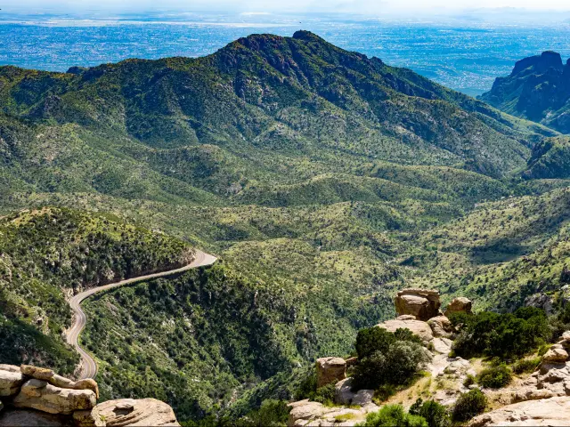
How to get there: This is a winding route with lots of turns and switchbacks that allow you to get the best views of the landscape. The drive from Tucson to Babad Do'ag Scenic Overlook is roughly 50 minutes along West Grant Rd and East Catalina Highway.
Once you reach the Babad Do'ag Scenic Overlook, you will be at the edge of the national forest and you just need to follow the winding paved road all the way to Mt Lemmon. The name changes from Catalina Highway to General Hitchcock Way as you drive along through the forest.
Scenic stops/overlooks:
- Babad Do'ag Scenic Overlook — Arid but dotted with green bushes, this scenic overlook will find you surrounded by different types of cactus and desert plants. This spot is at the base of Mt Lemmon and is the first viewpoint to make sure you stop at during your drive.
- Molino Canyon Vista — A beautiful spot to take in the scenery, this vista boasts multiple waterfalls and sightings of butterflies!
- Bug Spring Trailhead — The trailhead is the start of a beautiful 9.5 mile hike to the summit of Mt Lemmon, but you will want to stop here anyways during your drive in order to observe the mountain views.
- Thimble Peak Vista — See the sharp jutting rocks of thimble peak from this spot on Catalina Highway. Viewed from the right angle, it looks like two thumbs of rock were placed at the top of the mountain peak. It's also known as a great place for birdwatching.
- Windy Point Vista — Take some time to walk the pedestrian walkway at this resting place, from which you get spectacular views of Tucson below. The massive Hoodoo rock formation is a popular landmark at this stop.
- Hoodoo Vista — You can see lots of these Hoodoos all along the ride upwards, and this spot allows you to glimpse some particularly precarious-looking hoodoos along the rocky mountain side. These strange rock formations look like jenga towers made of stacked layers of rocks.
- Willow Canyon — This canyon in the mountainside is a great place to park the car and start exploring by foot. The views of the landscape are incredible from this point of elevation.
Our highlights: Considered a “Sky Island” because of the lush wildlife that is able to flourish on this mountain in the middle of the desert, Mt Lemmon is an oasis of nature and beauty.
The flora and fauna observed here, like the multiple species of cacti and birds, can only exist at this high elevation that is much cooler than the desert floor below.
The Catalina Highway is the only paved road that takes you 7,000 feet to the summit of the mountain. As you follow the winding highway up the sides of the mountain, the panoramic vistas become all the more spectacular the higher you go.
One of the most unique features of Mt Lemmon are the Hoodoos— the bizarre stacks of rocks that look like they will tumble as soon as the wind blows. Impossibly these rock towers remain stacked and intact, and they are certainly a site to be seen.
Marvel at the multitude of Hoodoos along Wilderness of Rocks Trail. This hiking trail starts at the Marshall Gulch Picnic Area and takes you on a 13-mile round-trip hike through the Pusch Ridge Wilderness. It's known as a strenuous hike that takes about 9 hours to complete. Y
es, that means you will want a whole day to get to the Wilderness of Rocks Vista and back again, but everyone who has laid eyes on the landscape raves about how utterly worth it the views are.
Once you finally reach the peak of Mt Lemmon, the panoramic views from the mountaintop will take your breath away. The unique rocky landscape is dotted with greenery that turns arider further down the mountain's base. The terrain is unmatched anywhere else in the United States.
Where to stay: You will most likely want to stay in Tucson for this road trip as it is the closest major city to the Coronado National Forest. The DoubleTree by Hilton Tucson Reid Park is a great option. This is mainly because of its ideal location, close to everywhere else you would need to go.
The hotel is located within 4 miles of downtown Tucson, so all the dining and entertainment the city offers are close at hand. From there, it is only a 35 min drive to Babad Do'ag Scenic Overlook, the start of the scenic drive.
Fun facts: You will get to see the Arizona state flower, the Saguaro Cactus as you enter the park at Babad Do'ag Overlook. These tall multi-armed cacti are the quintessential image most people have when they think “cactus”.
Our travel tips: A regular day pass to drive along the Catalina Highway costs $8 and can be paid at the Palisades Visitor Center. The Wilderness of Rocks trail requires a $5 day pass.
There are multiple other places to purchase passes, but if you're in Tucson you can go to the Coronado National Forest Supervisor's Office.
Spring is the best time to visit as you will get the best chance of seeing birds, butterflies, and runoff water streams.
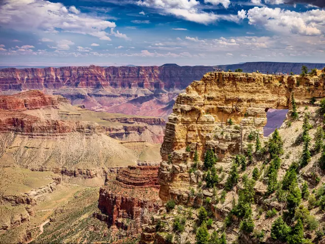
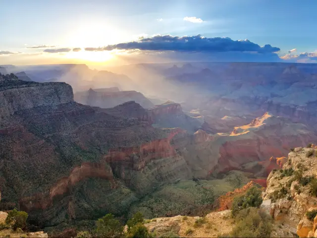
5. The Grand Canyon South Rim Scenic Drive
30 miles (50 minutes)
Near Flagstaff
What makes this scenic drive special: On this breathtaking drive, you will get to see the deep gorges of the canyon, the winding waters of the Colorado River, and the famous striped cliffs that mesmerize all who look upon this physical landmark.
This side of the Grand Canyon is the most popular with tourists and is the viewpoint used in films and tv shows. If this is your first visit to the Grand Canyon, you may want to start here as the views are expansive and give you that great landscape panorama. There is also a lot to do on this side of the canyon.
How to get there: Start in the town of Tusayan and go route 64 North until you're outside of Grand Canyon Village. You will turn onto route 64 East, or also called Desert View Drive, and keep following this road all the way along this route.
Scenic stops/overlooks:
- Pipe Creek Vista — A northern-facing view that oversees the magnificent red layered rock of the canyon.
- Duck on a Road —These rock formations can resemble castles, animals, and endless shapes. Many people seem to see a duck!
- Grandview Point — A magnificent panoramic view of the canyon and Colorado River.
- Moran Point — A viewpoint of the canyon that shows off scenery popular in Thomas Moran paintings. From here you can see the “Basement Rocks”, the oldest layer of rock in the entire canyon.
- Tusayan Pueblo Site — An archaeological site revealing the remains of dwellings dating back to the second century. It is one of 6,000 ancient sites discovered in the canyon.
- Lipan Point — See the Hance Rapids waterfalls, the Unkar Delta Publoan archaeological site, and the Grand Canyon Supergroup.
- Navajo Point — A view of the Desert View Watchtower. This is the highest overlook on the South Rim route at over 7,460 ft.
- Desert View — Another great overlook of the canyon. You need to walk from the parking area to the canyon rim in order to see the huge bend in the Colorado River, and you can climb the Desert View Watchtower.
Our highlights: This route is called “Desert View Drive” because it is on the desert side of the canyon, with the North Rim being more forested.
There are countless guided tours and activities to partake in, and the proximity to Grand Canyon Village makes it accessible to first-timers. Also from the South Rim you can reach the canyon floor via a multi-day hike and you can kayak on the Colorado River.
If you have time, take a hike along the Trail of Time. For all those interested in the science and geology of the Grand Canyon, learn how it was formed into what it is today. It is a flat walking trail with self-guided informative stops along the way.
Grand Canyon Village is where a lot of hiking trails start and where people congregate for entertainment and great food. The village offers restaurants and souvenir shops, as well as multiple lodging options if you don't want to stay in Tusayan and want better views of the Canyon from your hotel.
Where to stay: While visiting the Grand Canyon's South Rim, we recommend staying at Holiday Inn Express Grand Canyon, which is conveniently located in Tusayan, which is the start of this South Rim route.
Surrounded by the lush Kaibab National Forest, this modern hotel has a fantastic swimming pool to cool off or relax at after a long, adventurous day of exploring the Grand Canyon.
Make sure to sample their delicious breakfast before heading out to continue your exploration in this world-famous natural wonder.
Fun facts: The Grand Canyon gets just under 6 million visitors every year, and about 4 million of those visit the South Rim, with 1 million visiting the North Rim and the rest venturing to the East and West ends.
Have you ever been to Rhode Island? It may be impossible to imagine, but the Grand Canyon is bigger than the entire state of Rhode Island in terms of square miles! The canyon boasts 1,904 square miles, versus the 1,212 square miles of the smallest US state.
Our travel tips: The Tusayan Pueblo Site closes for the winter, so if this site is on your to-do list, be sure to visit during the summer when it reopens.
Limited parking at Pipe Creek Vista and it is usually the busiest tourist spot on this drive. The Kaibab Rim shuttle bus, which is free to ride, also takes you past this viewpoint.
A vehicle entrance fee for the South Rim is $35. Pre-purchase your tickets at either the South Entrance Station (5 minutes outside Tusayan) or the Desert View Entrance Station.
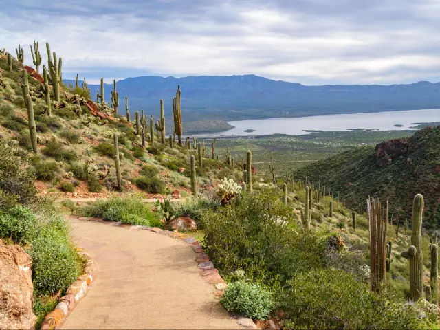
6. Apache Trail Historic Road
40 miles (2 hours)
Near Phoenix
What makes this scenic drive special: This route offers both Native American history as well as Old West history. The historic Route 88 follows a road first used by Native American peoples to traverse the Superstition Mountains. The same route was later used as a wagon trail by Western settlers.
There is so much history on this trail that you will want to make multiple stops. You can see two historic western towns, take a self-guided tour of the local flora and fauna, and see ancient Native American monuments.
How to get there: The closest major city to the start of this route is Phoenix, AZ, about a 41 min drive to Apache Junction. Those who live out of state can conveniently fly into Phoenix Sky Harbor International Airport.
To take this scenic drive, begin at Apache Junction and follow Highway AZ 88 East, which is also called North Apache Trail. Stay on this highway for the entire journey.
Scenic stops/overlooks:
- Superstition Mountain Lost Dutchman Museum — At this museum, you will get a good primer on the drive by learning about Old West & mining history. It is also near the sites of Dutchman's Gulch Western town, Apache Village, and a great nature trail.
- Goldfield Ghost Town — A recreation of a small western town where you can take fun tours and see a demo of a cowboy gunfight.
- Weaver's Needle Vista Viewpoint — A great stop to view the desert hills dotted with local cacti and other flora.
- Lost Dutchman State Park — This 320-acre desert park is good for a picnic break and a peaceful walk.
- Canyon Lake Vista — This viewpoint offers beautiful views of the 900-acre lake surrounded by red cliffs. Canyon Lake was created by the Mormon Flat Dam.
- Tortilla Flat — This small historic community was the last stagecoach stop along the Apache trail where travelers could rest and reload supplies on the journey west.
- Apache Lake — A little isolated and less populated by tourists, Apache Lake is a serene spot for a picnic or a short driving break.
- Theodore Roosevelt Dam — An impressive piece of US history, the dam was built in 1911 and made it possible for large-scale settlement in the center of Arizona.
- Tonto National Monument — See the ruins of Apache cliff dwellings, built around 700 years ago still sitting in their rocky home. The Lower Cliff and Upper Cliff sites must both be walked to, though the latter are only accessible via guided tour. The site is located a little further along Route 88 from Roosevelt Dam.
Our highlights: Take some time to explore Phoenix, the capital city of Arizona. There is no lack of things to keep you entertained during a stay in this fun outdoorsy city.
The Goldfield Ghost Town is an absolute must-see along this route. If you are going to make only a few stops, make sure you include this one. There is a lot to learn, a lot to see, and a plethora of dining options. This attraction is located early along the route, just 8 minutes from Apache Junction.
The beautiful Tonto National Monument is an essential stop for history buffs. Ancient Tonto sand dwellings are tucked into an alcove in the cliffs of Cholla Canyon. The site lies further down from the Roosevelt Dam and is the final stop we recommend making along this route.
Do a scavenger hunt to see how many local animal species you can spot at the Lost Dutchman State Park. There is a good chance you could encounter Desert Mule Deer, Desert Cottontail Rabbits, Roadrunners, and Gila Monsters! Be careful of spotting coyotes and bobcats, though thankfully neither are commonly seen during the daytime.
Where to stay: During your visit, we recommend staying in Mesa, a suburb of Phoenix, at the Residence Inn by Marriott Phoenix Mesa East.
The hotel is in a great location, situated between the airport and the start of our scenic driving route. Downtown Phoenix is roughly a 17 minute drive from Phoenix-Mesa Gateway Airport, and it only takes 12 minutes to drive to Apache Junction from the hotel.
Free parking and free breakfast — all a plus in our book! This comfortable and clean hotel provides everything you need on a trip to Phoenix.
Fun facts: The Apache Trail is part of the collection of Native American experiences called the Southwest Indian Lands Itinerary, which itself is a 1,325-mile loop through multiple states.
The route spans across many cities in the Southwest, visiting historic Native American sites from Phoenix AZ to Blanding UT to Farmington NM. A nonstop drive of this massive loop would take over 17 hours.
Our travel tips: The Apache Trail is lots of fun, but this road is winding and narrow, so it can present a challenge to new drivers. We should also mention that most of SR 88 is unpaved.
In the past, there have been road closures west of Tortilla Flat for some excursions, like access to Apache Lake, so they are best viewed from the viewpoints along Route 88.
But don't let the road conditions bring down your enthusiasm for this fun road trip! The low cost of entry to most sites is a huge plus. The Tonto Monument charges a fee of only $10 per person. Similarly, the Lost Dutchman Museum is affordable to visit with general entry being only $7 per person.
7. Patagonia-Sonoita Scenic Road
80 miles (1 hour 30 minutes)
Near Tucson
What makes this scenic drive special: Explore the Santa Cruz River Basin and Patagonia wine country on this next historic scenic drive. Our route takes you across varied terrain covering Sky Island, canyons, forests, and desert.
The landscapes around the region of Patagonia offer the most beautiful views to accompany your drive. This road trip combines its stunning landscapes with Arizona history dating back to its Spanish occupation.
How to get there: From Tucson, take I-10 East for about 24 miles until you reach Vail. Then you turn right onto AZ Route 83 South.
You will pass the Santa Rita Foothills and through the Las Cienegas National Conservation Area Grasslands. These are both gorgeous areas to drive through, so enjoy the scenery!
When you reach the town of Sonoita, turn onto AZ 82 West and follow this road for the remainder of the drive. You will pass the town of Patagonia and the Patagonia Lake State Park. Your journey will end at the town of Nogales near the border with Mexico.
Scenic stops/overlooks:
- Santa Cruz River Basin — This large stretch of land from Tucson to the Mexican border is where the Santa Cruz River and its offshoots used to flow before American settlers dried the river out in the late 1800's. Now the river returns seasonally to quench the diverse landscape that depends on its waters.
- Patagonia Museum — The city of Patagonia is an old mining town, and the Patagonia Museum tells the history of the area, including the wildlife and the story of its human settlement.
- Patagonia Lake State Park — Cross the famous Patagonia Lake Footbridge and take in this beautiful park. The park centers on Patagonia Lake and is home to much wildlife, such as whitetail deer and blue herons.
- Mission San Xavier del Bac — This working chapel was constructed in the late 1700's as a Catholic mission to the area, when this part of the country was still called New Spain. It is a beautiful building featuring Spanish architecture, and it is historically significant to the area.
- Tubac Presidio State Park — This state park's mission is to preserve the remains of the 1752 fortress of Ignacio de Tubac, the oldest site in Arizona that harkens back to the area's Spanish occupation. The park is also a great place to explore the area's Mexican history and the site of archaeological finds.
- Empire-Cienega Resource Conservation Area — The over 45,000 acres that make up these grasslands are considered Sky Islands, places where wildlife flourishes in pockets within the otherwise desert Arizona landscape. For an unforgettable experience, try a horseback riding excursion.
- Nogales — The city of Nogales on the US side of the border is known for its fun shopping and authentic Mexican cuisine. This is the perfect stop to your drive as you can get a delicious bite to eat and have an “over the border” experience without whipping out your passport.
Our highlights: The Santa Cruz River Basin was used as a migratory and trade route by the Hohokam native peoples who were searching for an alternative route to crossing the dry and more dangerous Sonoran Desert.
The Santa Rita Foothills are a stunning landscape overlooked by the Patagonia Mountains. The main draw of this drive is the beautiful scenery that changes with every mile, so you will never get bored looking out your window as you cruise along.
It's well worth it to take the 40 min detour from Patagonia to the Sun Rafael Valley. This is one of the most beautiful parts of the Santa Cruz River Basin, where stalks of tall yellow grass sway ethereally in the breeze. The windy valley, with the Santa Rita Mountain towering in the background of a flat expanse of golden grass, is sure to take your breath away.
Many stops on this scenic drive focus on this colonial history, taking you back to before the Mexican revolution with landmarks such as Mission San Xavier del Bac and Ignacio de Tubac.
Where to stay: A really great way to enjoy Tucson is to book a stay at the Hotel Congress. Located in a historic building, the hotel is now a cultural landmark for the city.
Since it's right in downtown Tucson, you will be able to explore the city with ease. You'll be just steps from the culture and entertainment Tucson offers, though the hotel itself conveniently includes a nightclub and an award-winning restaurant.
But the best part about the Hotel Congress is its attention to detail. The entire hotel is decked out in historic 1930's decor and includes things like vintage radios in each room. The aesthetic is kept historically accurate with a beautiful and chic twist.
Fun facts: The Hohokam culture flourished between 300 and 1500 AD. They were known to flourish in desert environments that they learned how to master.
If you want to see the ruins of a Hohokam home, you can visit the Casa Grande Ruins National Monument, located about an hour north of Tucson. It is a fun detour that will add to the experience of driving through the Santa Cruz River Basin.
Our travel tips: Some of the major sites on this route, besides the natural wonders of course, are free to enter. These include the Mission San Xavier del Bac church and, wonderfully, the Patagonia Museum.
However, some popular stops include entrance fees. The Tubac Presidio State Park costs $7 for adults and $2 for children aged 7 to 13. Because it is a popular camping ground, the Patagonia Lake State Park costs $15 per vehicle.
8. Arizona's White Mountains
100 miles (2 hours 20 minutes)
Near Show Low-Pinetop Lakeside
What makes this scenic drive special: Marvel at the White Mountains on your drive from the small town of Show Low to Alpine. On the way you will stop at the quaint mountain villages of Pinetop-Lakeside and Greer, both popular tourist destinations in the fall when the leaves turn bright red, orange, and yellow.
In the spring there are charming bubbling brooks and bright wildflowers in bloom. In the fall, the changing leaves draw people from miles around, including from surrounding states.
How to get there: From Show Low, take AZ Route 260 East through the White Mountains. You will pass the town of Pinetop-Lakeside, and you will be surrounded by the beauty of the mountains all around.
Continue on until the detour to Greer, where you can explore the small mountain village before going back to Route 260. This is also the area of Apache-Sitgreaves National Forest.
Just outside Eager, AZ, you will want to switch highways to US-191 South and follow this new road all the way into Alpine. Here you are very close to the New Mexico border and surrounded by the stunning Apache National Forest.
Scenic stops/overlooks:
- Show Low — This small town in Navajo County has a unique history and offers lots of dining options and many outdoor recreational activities. You will want to stop by the Show Low Historical Museum to see local artifacts and learn about the founding of the town in 1870.
- Pine forests & fall foliage — Historically the home of the White Mountain Apache Tribe, this forest is sacred to native people and has become a protected area. The scenic landscape has a tranquil beauty with the pine trees growing up the sides of the mountain, and you can see why it is still a holy place to native peoples today.
- Pinetop-Lakeside — This mountain town is a camping heaven for outdoor enthusiasts, with the largest Ponderosa Pine forest in the world and over 200 streams and lakes to explore. Visitors can enjoy many fun events throughout the year as well as dining and shopping in the town proper.
- Greer — Thousands of visitors flock to Greer annually to enjoy the crisp mountain air. In the winter the mountain village is covered in snow and hosts people for ski adventures and cozy cabin stays. It is a quaint stop along the White Mountain scenic drive, only minutes down Route 373 off Route 260.
- Apache-Sitgreaves National Forest — This national forest on the Mogollon Rim boasts eight cold-water lakes and over two million acres of land. Besides the fishing, hiking, and biking the area offers, there are many species of flora and fauna that call the forest home, including the Mexican spotted owl and the New Mexico Meadow Jumping Mouse.
- Alpine — Another mountain town in the White Mountains known for its access to the great outdoors, Alpine is particularly known for its bird watching. Over 100 species of birds call the area home. The town is also proud of its clear night skies and boasts the best stargazing.
Our highlights: The White Mountains are also one of the only places you can escape the perpetual Arizona heat. This tall mountain range, part of the Colorado Plateau, contains Arizona's second-highest peak, Mount Baldy, at 11,400 ft elevation. The town of Pinetop-Lakeside, for instance, sits at 7,000 feet above sea level.
For this reason, the weather is much cooler up here. Even though most parts of Arizona regularly reach temperatures of over 100 degrees Fahrenheit in the summer, the White Mountains have historically reached average highs in the 80s, even in the months of July and August.
This driving route gives you the best views of the White Mountains by following part of the traditional White Mountain Byway, taking you east from Show Low and traversing the Apache-Sitgreaves National Forest to reach Alpine.
The Ponderosa Pines and miles of forest climbing the mountains are magical sites along this route, sure to make your drive a pleasant and beautiful one.
The small 50-person town of Greer is popular seasonally with people who want to see the leaves changing. Even though these towns are open year-round, they are quiet except for peak seasons in the autumn when tourists flood in to experience their scenic charms.
The White Mountains Balloon Festival takes place in the summertime and is free to the public. More than 20 colorful hot air balloons are launched early in the morning in the town of Pinetop Lakeside. The event includes a concert, food vendors, and a beer garden.
If you want to take a detour to experience Native American history, the Casa Malpais Ruins is an interesting stop to make. On the regular route you will enter the town of Eager, AZ, from which you can detour 9 minutes north to Casa Malpais Archaeological Park.
The site features ruins dating back to the year 1260 when the Mogollon tribe lived in the area.
Where to stay: Located in the pine forests of Woodland Park, the Northwoods Resort Cabins in Pinetop-Lakeside offer a distinctive lodging experience. Get your own private cabin nestled in the peaceful forest and be surrounded by nature during your stay.
Each cabin has free wifi, a covered porch, and onsite laundry. There are different layouts and a number of beds to choose from, and the cabins are equipped with either gas or wood fireplaces that make the nights cozy and warm.
The clearing where the Northwood Cabins are situated is the start of many hiking trail systems, so you can explore the woods and marvel at the flora and fauna up close.
It is definitely a unique experience to stay in a cabin instead of a hotel, and you don't often get the chance to stay in such charmingly rustic lodgings. We say take the opportunity to experience Woodland Park for a night or two before setting off on the bulk of your scenic drive.
Fun facts: The town of Hon Dah just south of Pinetop-Lakeside is the traditional starting point for exploring the White Mountain Byway, and it is named after the Apache word for “welcome”.
Our travel tips: The Casa Malpais Ruins are free of admission cost, but they are accessible only by guided tour and require a two-hour hike to reach. The path is steep and rocky, so take care and bring a full water bottle.
Any time of year is great to visit the White Mountains, with each season offering its own particular charm. The advantage of taking this drive in the summer is you will get to escape the heat of mainland Arizona. It is a great time to partake in kayaking and fishing.
The spring is full of streams and blooming wildflowers, and the landscape is green for miles around. The fall is usually the most crowded time since people want to see the leaves change. The winter sees the mountains covered in snow and you can ski in Greer.
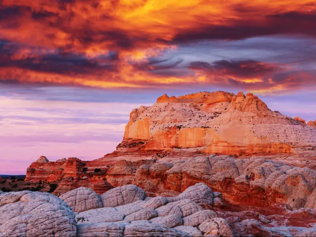
9. Fredonia-Vermilion Cliffs Scenic Road
110 miles (2 hours)
Near Fredonia
What makes this scenic drive special: This scenic drive through Arizona's desert will take you on a winding path from Fredonia by the Utah border—right outside the Kaibab Indian Reservation— past the Vermilion Cliffs and ending in Page.
You will reach your epic destination in the Marble Canyon and Lake Powell, there are many excursions that could keep you occupied for days.
Yet another perspective of Arizona's fascinating desert, the drive from Fredonia to Page features unique rock formations and takes you through the Vermilion Valley, which makes up an elevated level of the Grand Staircase geological formation that includes the Grand Canyon at its base.
You will notice the landscape slowly change from desert plains to forested terrain as you continue your drive toward Bitter Springs. Desert flora, like the dry scrubby bushes endemic to the region, will morph into oak and aspen trees.
How to get there: Fredonia is usually where people begin their journey to see the north rim of the Grand Canyon, but you will take a different journey from here. Follow US-89A South all the way into Bitter Springs. After you reach Bitter Springs, stay on I-89 North to Page, AZ.
It is a straightforward drive with lots of stops along the way so that you can view the natural landmarks. The road becomes windy around Jacob's Lake where the landscape is more forested.
The highway will make a big curve again as you cross the Colorado River while passing through Marble Canyon. The twistiness allows for lots of leisurely scenery viewing, so set your pace to a cruise and enjoy the ride!
Scenic stops/overlooks:
- Le Fevre Overlook — This viewpoint rest stop is located just outside Kaibab National Forest, with binocular-fitted overlooks that allow for sweeping sights of the Grand Staircase-Escalante National Monument and an immense span of the surrounding terrain.
- Pasture Canyon Lookout — A stunning lookout point that allows for a wide-lens view of the arid landscape between the cliffs.
- Vermilion Cliffs — Getting to the Vermilion Cliffs National Monument involves a hike from Marble Canyon, but you will pass by the cliffs themselves on your drive. They will be towering in the distance as you cruise along I-89A.
- Marble Canyon — Named for its striped appearance from the layers of packed sandstone sediment, Marble Canyon is a beautiful destination with an unforgettable landscape. This smaller canyon makes up the beginning of Grand Canyon National Park.
- Historic Navajo Bridge – Named thusly because of the location on Navajo land, this site actually contains two bridges that cross the Colorado River and have a history with American pioneers. The old bridge is now a footpath that also allows horseback riders.
- Antelope Pass Vista – The mountain pass itself sits at an elevation of over 6,000 ft at the end of a winding mountain road. Get a glimpse of it from the vista viewpoint in Marble Canyon, with the Vermilion Cliffs dominating the distant landscape.
- Horseshoe Bend — One of the most wondrous views of the Colorado River, Horseshoe Bend is a must-see on your way to Page, AZ. The river curves around the eroded cliff rock. At 1,000 ft elevation, the viewpoint gives you a magnificent look at the river's winding path.
- Lake Powell — This famous lake receives over 3 million visitors a year as a result of the stellar and varied recreation opportunities available.
Our highlights: For a quirky excursion while at Marble Canyon, take a quick 4 min detour up Lees Ferry Road. On your left, you will see Balanced Rock, a cool eroded rock formation that looks like a bulky boulder balancing on a pedestal.
Once you reach Marble Canyon, there will be a few rest stops in the area where you can park the car and explore. That is, after you've taken your fill of pictures and marveled at the striped cliffs of the canyon.
Horseshoe Bend is a bucket list stop that you won't want to miss, especially because it is one of the most photogenic spots on the Colorado River. Get ready for a photo op by the u-shaped stream of water as it twists around the cliff edge.
Top up your tank at the Chevron gas station, stock up on provisions at the Marble Canyon Trading Post, learn about the history of the twin bridges at Navajo Bridge Interpretive Center, and shop around at the Antelope Trails Interpretive Market jewelry store.
Once you reach Page, we recommend stopping overnight so that you have time to explore some of the natural landmarks in the area. Not only are there lots of hiking trails, but you can also continue north onto Lake Powell where you can partake in a plethora of outdoor adventures.
Kayak on the lake, take a boat tour, and make a point of seeing the Slot Canyons.
The Slot Canyons are unforgettable walkways through narrow cliff edges where you will be surrounded by the striped rock sediment on two sides. It is a breathtakingly beautiful experience that we urge you to try on your stop in Page.
Book the tour that best suits you, as there are various slot canyons that vary in difficulty to traverse.
Some of the most memorable slot canyons exist in Antelope Canyon, just an 8 min drive from Page.
Where to stay: You will not want to stay anywhere other than the Courtyard Page at Lake Powell. The hotel is situated in the perfect location on the western side of Page, AZ right off of I-89. Drive just 5 minutes to reach all the fun recreation available at Lake Powell.
With an onsite restaurant, an outdoor pool to cool off in, and comfortable rooms, this hotel offers everything you might want on a trip to Page. It is the ideal resting place after all the adventures you will have on this road trip.
Fun facts: You may be surprised to know that Lake Powell is not a natural lake! It was created by the Glen Canyon dam, which flooded the area and created the man-made lake that is now a major tourist attraction in the US.
You may want to stay in the area longer than one night when you hear that there are over 196 canyons that branch off Lake Powell's main water channel. It would take days to explore even the handful of popular canyons well-known to tourists.
Our travel tips: The entrance fee to Lake Powell is a steep $30, but it is valid for a whole week. You may want to extend your vacation and get the most out of your entrance pass. It will also allow you to explore the area more thoroughly, as there is a ton to do!
Parking at Horseshoe Bend is $5 per car, and we think it is well worth the fee. It is one of the most memorable sites in the area and you will want to snap a picture of yourself by the bending Colorado River.
With over 3 million visitors every year and the busiest time being the summer months, you should consider doing this road trip in the spring or fall to avoid the crowds.
10. Historic Route 66
280 miles (4 hours)
Near Kingman
What makes this scenic drive special: This is a different kind of history trip that explores the quirky side of American history. Route 66 is known for its kitschy small towns and its focus on American pop culture. Referred to as the Mother Road, this 90-year-old road is extremely popular for family vacations.
Route 66 connects multiple quaint towns and fun attractions, like vintage billboards, old motels, ghost towns, old general stores, diners, iconic statues, and more.
How to get there: From Kingman, take Route 66 north and follow it through Seligman. Historic Route 66 has also been named Interstate 40 around this area, so follow I-40 East the rest of the way into Flagstaff.
You will continue along the same road all the way to the Petrified Forest.
To see some of the famous landmarks, like Walnut Canyon National Monument and Meteor Crater, you may have to turn off the highway and follow a smaller road. But most of our key stops are actually small towns sitting along the highway that offer their own quirky and fun attractions!
Scenic stops/overlooks:
- Kingman — Called “The Heart of Historic Route 66”, this small town is the perfect place to start the trip. You can add a visit to the Route 66 Museum and the Hackberry General Store.
- Antares — In this town, see the Giganticus Headicus statue, the1965 Rancheros Motel, and the 16 ft tall Guardian of Route 66 statue.
- Valentine Ghost Town —The tall red-bricked Truxton Canyon Training School still stands in this infamous town with a turbulent Native American History where Hualapai, Mojave, Apache, and other native children were taught to assimilate into American society.
- Truxton — You will find most Route 66 landmarks and attractions located in this tiny, nearly abandoned town.
- Peach Springs — Located within Hualapai Indian Reservation, this stop is also the site of the historic Peach Springs Trading post
- Seligman — Nicknamed the “Birthplace of Historic Route 66”, Seligman is home to vintage businesses, vintage cars, and lots of kitschy gift shops.
- Flagstaff — Surrounded by mountains and lush pine forests, Flagstaff has a reputation with outdoor enthusiasts. It is close to seven National Parks, various national monuments, and is well known for its clear night skies and astrotourism.
- Twin Arrows — Get a glimpse of these 25 ft arrows that served as an easy-to-spot landmark for travelers on old Route 66.
- Walnut Canyon National Monument — Visit the mesmerizing Native American Sinagua cliff dwellings at Walnut Canyon, outside Winona.
- Meteor Crater (or Barringer Crater) & Meteor City — Located between Winona and Winslow, this is the site of a huge meteor crash that left an impression about 1 mile across and 550 ft deep. The collision happened about 50,000 years ago.
- Two Guns — A ghost town with lots of sordid history, Two Guns is known to be the hiding place of Billy the Kid when he and his gang hid in nearby Canyon Diablo in the winter of 1880.
- Winslow — There are lots to explore in Winslow including the Hopi Cultural Center, Rock Art Ranch, and the fascinating Old Trails Museum.
- Joseph City -—This town is known as the US's oldest Mormon settlement and the site of the famous “Here It Is!” sign, which makes for a great photo op.
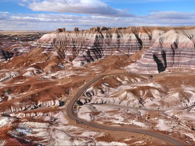
- Holbrook — During your stop, make time to visit the unique Wigwam Village hotel full of teepees, and take a self-guided town tour that takes you past historic places like the Bucket of Blood Saloon. You will also be able to see the beautiful Painted Desert sands this far down Route 66.
- Petrified Forest National Park — The ultimate finale to your drive takes you away from the pop culture sites of Route 66 and brings you back further in history, to about 225 million years ago. The 346-square mile park is covered by thousands of petrified wood fossils dating back to the late Triassic period—meaning these old tree specimens were around during the birth of the dinosaurs!
Our highlights: The entire historic Route 66 connects Los Angeles to Chicago, first created to assist travelers across the vast expanse of the United States. But our route from Flagstaff to Petrified Forest National Park remains within Arizona and passes some of the most fun stops along the way.
Kingman, the start of the journey, is one of the most fun towns to visit along this route because of the number of things to do and see. The Route 66 Museum will prime you for the significance of the sites along your drive.
To document your journey along the famous American highway, get your passport stamped! Collect 9 official town stamps and various stamps from local businesses with the Route 66 Passport and do a scavenger hunt of activities. Keep the passport as a fun souvenir from your road trip.
If you are looking for a detour that connects you to the magnificent Arizona landscape, the Painted Desert is breathtaking with its red-striped cliffs and panoramic scenery.
This is a can't-miss excursion that is easily accessible from Route 66. Drive roughly an hour north on a turnoff from the town of Sun Valley (between Holbrook and Petrified Forest National Park).
The locally known “Chocolate Falls”, or Grand Falls, is an unforgettable detour, sitting 38 min from Winona or 32 min from the town of Leupp. This waterfall in the Painted Desert cascades down tiers of cliffs where the brown sediment-rich water looks like flowing chocolate.
If you'd like to extend your adventure beyond Arizona and travel further on this legendary road, here is our guide on how long it takes to drive Route 66.
Where to stay: This is a pretty long scenic drive with a plethora of things to see and do. You might want to rest halfway through at the High Country Motor Lodge in Flagstaff.
Located in Flagstaff's historic district, this hotel gives a nod to the Route 66 era with its chic mid-century modern decor and aesthetic. It serves up a great experience of the Route 66 vintage vibe.
It's also a fun place to stay, with a game room filled with vintage arcade games, fire pits on the lawn, and great onsite dining. There is even a restaurant featuring pizza made from imported Italian pizza dough.
Fun facts: The term “The Mother Road” was first written by John Steinbeck in Grapes of Wrath, his novel about the great migration and dust bowl where the characters travel along historic Route 66. The novel was published in 1939.
Another nickname for this highway is “America's Main Street” because of the important pop culture iconography dotting the route.
Our travel tips: Though there is no cost to travel on Route 66, some attractions in town like museums may have their own fees. Meteor Crater is $22 per person, and entrance to Walnut Canyon costs $25 per vehicle.
To enter Petrified Forest National Park, it is $25 per car or $15 for individual admission.
The Route 66 Passport book is very affordable online at $1.66 before tax, and it includes a helpful traveler's guide.
*All of the prices mentioned in this article are valid at the time of writing

Sasha Yanshin – Founder & Lead Driver
Sasha Yanshin has spent the last 15+ years mapping and driving thousands of miles across Europe and the US. As the Founder and Lead Driver of Lazytrips, he brings an analytical approach to road-tripping, sharing meticulously tested routes, realistic drive times, and the hard-earned logistical reality of the open road.
Read full bio