Is Wolf Creek Pass Dangerous?
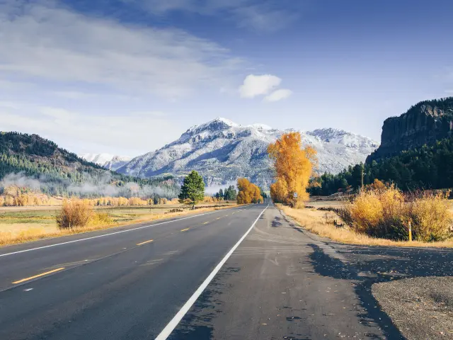
Sitting astride the Continental Divide, the Wolf Creek Pass travels through the Rocky Mountains in Colorado. Along the route, you can explore wilderness trailheads and winter sports and pause to appreciate the unforgettable mountain scenery, especially enchanting when covered with a sprinkling of snow.
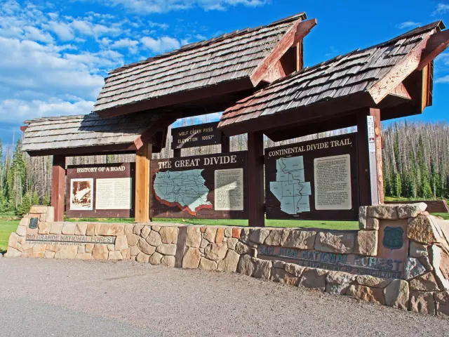
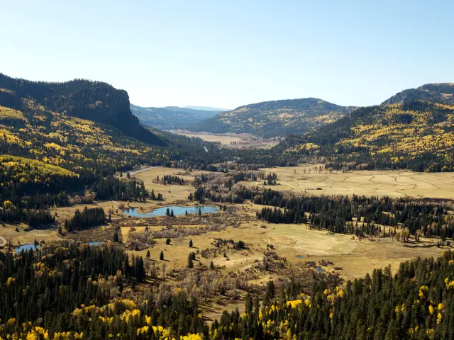
Wolf Creek Pass offers stunning views across Colorado's San Juan Mountains, ascending to 11,760 feet at Lobo Overlook. It's a spectacular drive but the inclines, tight turns and risk of snow might feel dangerous if you're not used to the conditions.
If you are keen to drive along one of the most beautiful mountain roads in the Colorado Rockies, keep on reading to find out more about Wolf Creek Pass, the route, and how you can stay safe along the way.
Where is Wolf Creek Pass located, and why might this drive be challenging?
Wolf Creek Pass winds between South Fork and Pagosa Springs through Colorado's San Juan Mountains. Situated in Mineral County, Colorado, it's often used to access the state's South and Southwest sections.
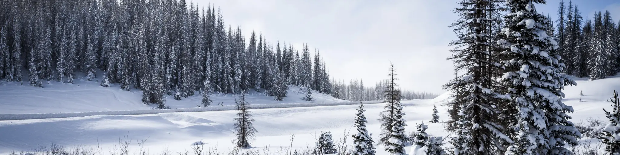
It's a remote road that makes a steep ascent up to high elevations, so even in good weather, this is a route that you need to drive cautiously. Severe winter weather can make driving conditions even more challenging through the colder months.
Even so, Wolf Creek Pass is an important road to reach South and Southwest Colorado from other parts of the state. Without using the road, you'll have to either detour through New Mexico or go through the Red Mountains.
Driving through Wolf Creek Pass
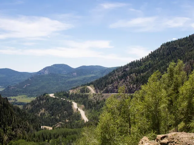
Wolf Creek Pass might look like a straightforward drive when you first see it on a map. Simply head south onto US-160 at South Fork then follow the road for 40 miles as it skirts past Fox Mountain, Lobo Overlook and Alberta Peak until you hit Pagosa Springs at the other end of the road.
Driving through the pass from South Fork to Pagosa Springs will take 50 minutes and span about 40 miles.
It is not that long of a drive but this is an area where you'll have to be comfortable driving at high elevations with steep inclines and switchbacks, through changeable or icy weather conditions where wildlife frequently ventures onto the roads.
The road is paved throughout, and usually in good condition, although severe winter weather can cause sudden damage to the road surface. Even so, its location in the mountains of Colorado means you'll need to plan carefully for a drive through Wolf Creek Pass.
The route reaches an elevation of over 11,000 feet at Lobo Overlook, with steep inclines either side of the pass in places. West of the pass you'll have to drive down a steep 7% descent too. This means it might not be the best route to travel if you're a nervous driver, or if you're afraid of heights.
Along with those high elevations come plenty of places to stop and admire the view. There are frequent lookouts, and you can stop at Wolf Creek Ski Area if you want to spend longer enjoying the dramatic scenery. However, you'll need to stay alert to vehicles pulling out onto the highway from scenic lookouts and the ski areas.
Another plus point for this drive is that, whilst there are some sharp curves on the drive through Wolf Creek Pass, this road isn't as twisty as many other routes through the mountains. Just watch out for the particularly dangerous hairpin turns around 6 miles past the summit at Wolf Creek Valley Overlook.
Services along the route are very limited, and there are no gas stations at all, so be sure to fill up before you set off. North of the route, the nearest gas stations are at Center or Alamosa. Otherwise, you'll have to wait until you've passed Pagosa Springs on US-160.
There is, however, an EV charging point along the route. You'll find it near Wolf Creek Ski Area if you need to charge up.
Alternative routes to reach Pagosa Springs from South Fork
You can avoid driving through Wolf Creek Pass if you bypass through New Mexico. However, traveling via New Mexico will be much more time-consuming and will take 3 hours and 15 minutes to cover 170 miles.
Traveling first through Alamosa and Antonito, this route dips into New Mexico through Charma then follows US-84 back up to Pagosa Springs.
There's even a longer option to take the Million Dollar Highway, which includes a long loop north via Lake City and Montrose, before joining US-550 to run south through the Red Mountains and then west to Pagosa Springs from Durango, clocking in 320 miles in 7 hours.
You might consider this alternative if the weather conditions close Wolf Creek Pass; however, this route also features fewer lanes and steep cliffs, so it won't be every driver's first choice. If you are nervous about steep turns and heights, we would not recommend using this alternative.
To help with your decision, you can find more information about whether the Million Dollar Highway is a dangerous drive here.
If, by this point, you have decided that driving through Wolf Creek Pass yourself doesn't appeal, then you can still visit Wolf Creek Ski Resort using the shuttle service from Pagosa Springs.
Things to know that can impact the drive through Wolf Creek Pass
Winter weather is probably the first question you'll look at when planning a drive through Wolf Creek Pass. Heavy snowfall, ice, and strong winds all increase driving risks between November and March.
In general, the traffic is light along the route, although it can be busier near Wolf Creek Ski Area during the winter season. As you might expect, holidays and weekends are usually busier than midweek.
It's no longer just a 2-lane road all the way, which makes driving through Wolf Creek Pass a little less challenging than it would have been in the past. On some parts of the road, you'll now find 4 lanes (2 in each direction), though there are still some places where the road is limited to 2 lanes on the ascent and 1 lane descending.
There are some really steep sections along the way, so make sure your vehicle is in good condition before setting out. For safety, there are two runaway ramps along the road, though hopefully, you'll never need to use them.
With two lanes on most inclines, you can pass slower-moving vehicles safely. However, for safety reasons, you can't cross to the other side of the road to pass.
Speed limits vary along the route, ranging from 25 MPH to 45 MPH, but don't expect larger vehicles traveling uphill to reach the upper end of this limit. In bad weather, consider dropping to lower speeds.
This area is a hotspot for wildlife, with black bears, lynx and elk all inhabiting the pass and surrounding areas. That's another good reason to drive slowly, and make sure you have space to react to any wildlife that might venture onto the road. Animals are most active at dawn and dusk.
In winter, you'll need to follow Colorado's laws on winter tires and chains. Check these out before you travel so that you have time to get hold of any new equipment you might need. There are also three chain stations along the road in case you need to stop.
The road can be closed at short notice if there's extreme snow, or if avalanche prevention measures are needed. Check the weather conditions for your trip online before setting out to avoid being caught up in a closure.
Finally, don't rely on GPS service to navigate through the mountains, as cell phone services can be very limited on the drive through Wolf Creek Pass.Tips to drive through Wolf Creek Pass in the safest way
Now that you've found out more about Wolf Creek Pass, here are our top tips to drive the route in the safest possible way:
- Make the trip during daylight to enjoy improved visibility and increased temperatures.
- Acclimatize to the altitude at lower elevations before making the drive, and make sure you stay hydrated.
- Avoid traveling on weekends and holidays, when you'll hit peak recreational traffic.
- Make sure your vehicle is fitted with winter tires or chains if you are traveling during the colder months.
- If you're hiring a car, inquire about winter-ready vehicles such as 4WD and make sure you get a vehicle with winter tires or chains.
- Make sure you have adequate fuel for your journey. Fuel up near South Fork or Pagosa Springs to avoid running low.
- Do not drive in heavy snowstorms and blizzards. Stay in hotels at nearby South Fork or Pagosa Springs instead.
- Check weather and traffic advisories. Use Colorado DOT and COtrip to keep up to date.
- Do a “virtual drive” using Google Street View so that you can prepare yourself and familiarize yourself with the route.
- If you choose to follow the longer alternative routes, have two designated drivers to share the load so you can stay fresh.
- Be mindful of HGVs and their limitations. Look ahead for heavy trucks crawling along the slow lane. Anticipate this and merge into the fast lane, ahead of them.
- Bring essentials such as blankets, water and snacks, especially during winter.
- Check your brakes before heading down from the pass, and use a low gear to relieve stress on the brakes during the descent.
Best time to drive through Wolf Creek Pass
As you might expect from a route like this, Wolf Creek Pass experiences notable seasonal variations.
In summer, the road is busy with tourist traffic. Hikers are attracted to the trailheads along the route, so you may experience more road use on pleasant summer days. Wildlife crossing is also more common in summer, so stay alert as you travel through Wolf Creek Pass.
Even in the warmer months, there's a chance that weather conditions can change fast in the mountains. Sudden, severe thunderstorms are common and can make driving more of a challenge.
Of course, snow and ice are among the main features of the route from November to spring. Make sure you're prepared for winter driving before setting out and drive cautiously, paying attention to icy patches on the road.
During heavy snowfall, temporary road closures might be enforced. Even when the road is open, always travel prepared for Colorado's chain laws and make sure that your vehicle complies.
Ski season at Wolf Creek Ski Resort brings many travelers to the route through the pass, which means it's possible to experience congestion during peak season.

Sasha Yanshin – Founder & Lead Driver
Sasha Yanshin has spent the last 15+ years mapping and driving thousands of miles across Europe and the US. As the Founder and Lead Driver of Lazytrips, he brings an analytical approach to road-tripping, sharing meticulously tested routes, realistic drive times, and the hard-earned logistical reality of the open road.
Read full bio