
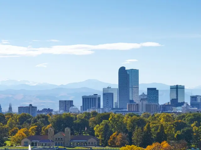
Road Trip from Denver to Zion National Park
Zion National Park is a 9.5-hour drive from Denver. The canyon is unlike the rest of Utah's desert parks - you get towering red walls, a green valley floor, a river you can wade upstream through, and one of the most famous hikes in America.
The route follows I-70 west through the Rockies and across the Utah desert, then turns south on I-15 before cutting back east on Highway 9 into Springdale - the small town at the park entrance. Leave Denver early in the morning and you can get to Zion before dinner.
🚙 EXPLORE MORE: The Best Road Trips From Denver
Read this before leaving Denver
🚗 Leave Early
You could stop overnight to break up the long drive, but that means using up 2 days to get to Zion. If you're going to do it in 1 day, make sure you set off early. Most restaurants in Springdale close at 9 or 9:30pm (The Zion Canyon Brew Pub stays open until 10). You've got a 9.5 hour drive, at least 2 fuel/rest stops, and time to check in - be on the road by 8am or you're eating a random gas station's finest for dinner.
🚌 No Cars in the Canyon
From March through November, private vehicles aren't allowed on Zion Canyon Scenic Drive - the road that accesses all the major trailheads. You take a free shuttle bus from the visitor center in Springdale instead. The shuttles run frequently and the system works well, but it means you can't just drive to a trailhead and park. Plan your day around the shuttle stops.
⛰️ Angels Landing Permits
Angels Landing is the most famous hike in Zion - a chain-assisted scramble along a narrow ridge with 1,500-foot drops on both sides. You need a permit from recreation.gov to hike past Scout Lookout.
The seasonal lottery runs 2-5 months ahead (apply in April for the summer) and you can pick up to 7 dates for your hike. If you don't get a permit, there is a day-before lottery that runs each day - you apply before 3pm and find out at 4pm. Both lotteries cost $6 to enter and you then pay $3 per person for the permits.
If you miss both, it's not the end of the world - you can hike up to Scout Lookout without a permit and the other trails are permit-free.
How many days do you need?
5 days is the perfect amount of time. The drive to Zion is 9.5 hours, so you're spending day 1 on the road. But the return route goes through Bryce Canyon and Highway 12 instead of retracing I-15, so you break up the return trip and pack in amazing scenery.
You get 2 full days at Zion, which means 2 chances at the Angels Landing day-before lottery if you didn't get the seasonal one. It also means you can do the two big hikes in Zion on separate days without rushing either of them.
Day 1: Drive to Zion
🚗 580 miles ⏱️ 9 hours, 30 minutes
Leave Denver early and drive west on I-70 through the Rockies, across the Utah desert, and south on I-15. Turn east on Highway 9 into Springdale. Check into your hotel and walk to dinner.
Day 2: Angels Landing & the Canyon
If you got an Angels Landing permit, this is the day. Take the shuttle to The Grotto stop, hike to Scout Lookout, and continue up the chains to the summit. Spend the afternoon exploring the lower canyon - the Emerald Pools trail is an easy walk from the shuttle.
Day 3: The Narrows
Take the shuttle to the end of the road and walk the Riverside Walk to where the trail ends and the river begins. Wade upstream through the slot canyon as far as you want and turn back. Rent water shoes and a walking stick from one of the outfitters in Springdale - you'll want both.
Day 4: Bryce Canyon & Highway 12
🚗 200 miles ⏱️ 4 hours, 15 minutes
Check out of Springdale and drive to Bryce Canyon for the morning - it's about 1 hour and 50 minutes and you're heading back in Denver's direction.
Spend a few hours walking the Navajo Loop and Queen's Garden trail into the amphitheater, then get back in the car and keep going east on Highway 12 through Grand Staircase-Escalante. It's one of the most scenic drives in America and it takes you all the way to Capitol Reef country. Stop overnight near Torrey.
Day 5: Drive Home
🚗 450 miles ⏱️ 7 hours
Pick up Highway 24 to I-70 and head east back to Denver. After 4 days of canyons and red rock, the drive through the Utah desert and back over the Rockies feels like a completely different trip from the one you took on the way out.
Where to stay
When you're visiting Zion, you'll want to stay in Springdale for the 3 nights. It's the small town right at the park entrance where shuttle buses take you inside Zion.
There's one hotel inside the park - Zion Lodge - but it books out a year in advance, has limited food options in the evening, and costs significantly more than staying in Springdale for no real gain in convenience.
The Cable Mountain Lodge is right at the park entrance with views of the canyon walls from your room. You're right by the park shuttle so you don't have to take a second shuttle from there to your hotel. Plus you're a short walk to everything in Springdale - restaurants, outfitters for Narrows gear, and, most importantly, the Brew Pub which stays open until 10.
Remember to book early if you're visiting between March and October. Springdale is small and the good hotels fill up fast, especially on weekends.
The Route to Zion
If you want more days in Zion, or to extend the trip to add stops in Moab or Vegas, you can customize your route in the Planner
The route starts heading west out of Denver on I-70 - the same mountain stretch as any other westbound trip from Denver. You pass through the Eisenhower Tunnel at 11,158 feet, Vail Pass, the Eagle River valley, and then Glenwood Canyon, which is 12 miles of interstate threaded through a narrow gorge with the Colorado River below you.
If you're driving between November and April, check road conditions before you leave — Vail Pass can close for snow and avalanches with little warning.
It's worth stopping at least once in Glenwood Canyon even if you're trying to make time - there are good places to pull in along the road.
After Glenwood Springs the mountains flatten out and you're in high desert by Grand Junction. Make sure you fill up here - the Utah stretch ahead is empty with 60 miles before the next pump.
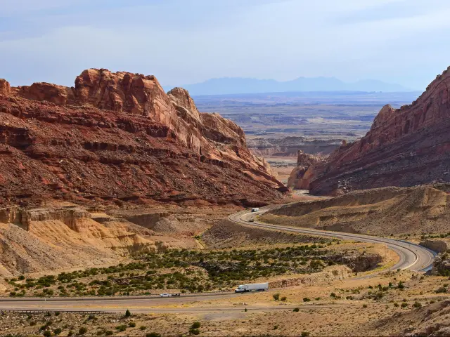
Once you cross into Utah, I-70 runs through the San Rafael Swell for about 100 miles of wide-open desert with few exits and no services. At Salina, I-70 ends and you join I-15 south. The landscape shifts again as you drop through Cedar City and into Utah's red southwest corner.
Take the Highway 9 exit near Hurricane and drive east through a short stretch of desert before the road climbs up to the park via the Zion-Mount Carmel tunnel - a mile-long tunnel carved through the rock in the 1930s.
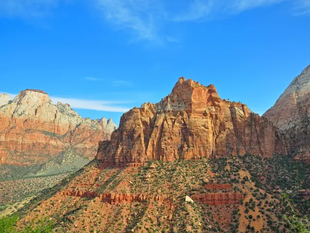
You come out on the canyon rim with the valley dropping away below - a dramatic entrance worth the long drive to get there.
Springdale is a few minutes further along as you drop into the canyon.
If you're in an RV or oversized vehicle, the tunnel requires a prebooked ranger escort to pass through - you'll drive down the center line and there's a fee.
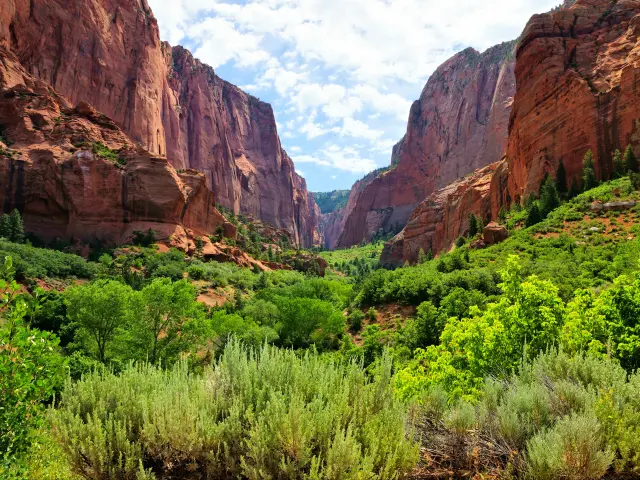
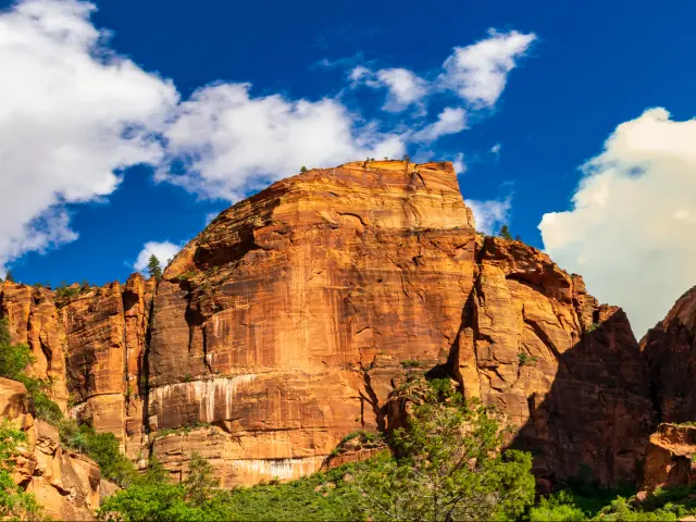
Zion National Park
Zion's main canyon is compact - the scenic drive is only 6 miles from the visitor center to the Temple of Sinawava at the end of the road. Everything branches off this one road, and from March through November the shuttle handles all of it. You won't need your car again until you leave.
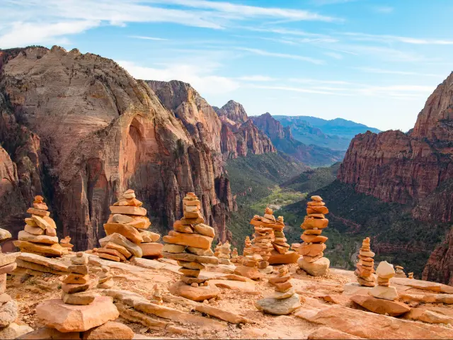
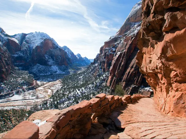
Angels Landing
This is the hike everyone comes for. The trail starts at The Grotto shuttle stop, climbs through a series of switchbacks called Walter's Wiggles, and reaches Scout Lookout at about 2 miles. The views from Scout Lookout are already spectacular and this is as far as you can get without a permit.
Beyond Scout Lookout, the trail becomes a narrow rocky ridge with chains bolted into the sandstone and drops of 1,500 feet on both sides. This is the section that needs the permit and the section that earns the reputation.
The sheer drops can easily make you uncomfortable if you're not good with heights - you'll know within the first few minutes whether you want to continue.
The full hike is about 5 miles round trip and takes 3-5 hours depending on how crowded the chains section is. Bring water as there's nothing along the trail.
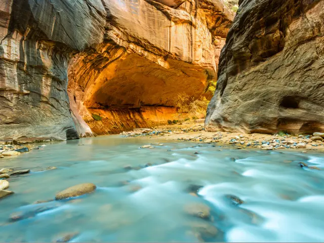
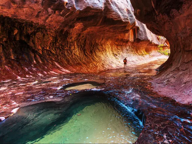
The Narrows
This is the other signature experience in Zion, and the complete opposite of Angels Landing. Instead of climbing above the canyon, you're walking through the bottom of it - wading upstream through the Virgin River between walls that narrow to 20 feet apart in places and rise hundreds of feet above you.
The hike starts where the Riverside Walk ends at the Temple of Sinawava - that's where the paved trail finishes and the river begins. There's no set distance for how far up the river the trail goes - you wade in as far as you want and turn back. Most people do 2-4 hours. The deeper you go, the narrower the canyon gets and the fewer people you see.
You'll need water shoes and neoprene socks - don't underestimate how slippery the cobblestones are and how cold the water can feel even in the summer.
You can rent these, as well as walking sticks, from the Zion Outfitter shop the evening before or early in the morning (they conveniently open at 7). The gear will set you back about $25-30 for the day.
Check river flow levels before you go. The park closes the Narrows when the Virgin River runs above a certain level, which is more common in spring - flash floods in slot canyons are genuinely deadly and the park takes it seriously.
Canyon Overlook Trail
If you need more hiking options, the Canyon Overlook Trail is a short, easy hike that many people miss. The trailhead is right at the east end of the Zion-Mount Carmel tunnel - you probably drove past it in the dark on the way in.
It's about 1 mile round trip and ends at a viewpoint looking down into Pine Creek Canyon and across to the main canyon.
Emerald Pools
These are three pools connected by a trail that climbs from the canyon floor. The Lower Emerald Pool is an easy, flat walk from the Zion Lodge shuttle stop - about half a mile to a waterfall and pool at the base of a cliff.
The Middle and Upper pools add more climbing and are quieter, but it's still a relatively straightforward hike.
This is a great afternoon walk for tired legs - short enough that nobody complains and very pretty for the amount of time you'll need to do it.
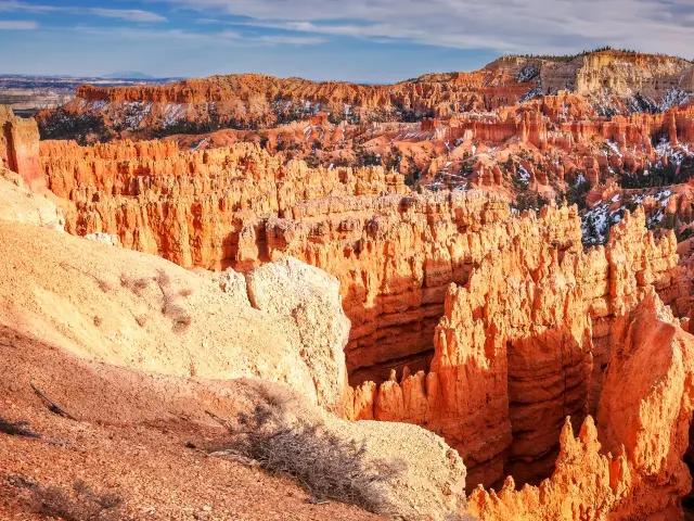
Bryce Canyon
Check out of Springdale on Day 4 and drive northeast toward Bryce Canyon. It's about 1 hour 50 minutes and you're heading in the right direction back towards Denver - you won't need to backtrack.
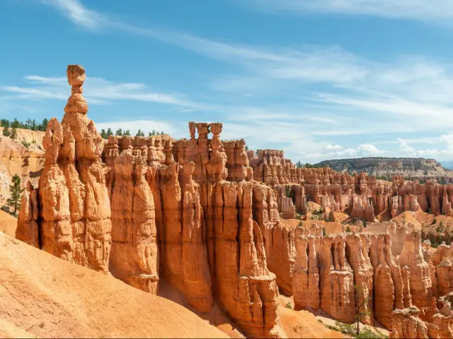
Bryce Canyon is a completely different landscape from Zion. Instead of deep canyon walls and a river, you're standing on the rim of a vast amphitheater filled with thousands of red and orange rock spires called hoodoos. They look like nothing else in the Southwest.
The Navajo Loop and Queen's Garden trails connect into a 3-mile loop that drops you down from the rim into the amphitheater among the spires. It takes about 2 hours and it's the one thing you shouldn't skip. The rim viewpoints are impressive too, so do both if you're not too tired from Zion.
You will only need to spend a few hours here even if you do both trails.
Highway 12 and the drive home
After Bryce Canyon, get back to Highway 12 and continue east. This is where the drive home stops being interstate logistics and becomes a highlight of the trip.
Highway 12 is an All-American Road that winds through Grand Staircase-Escalante National Monument - red rock canyons, slickrock ridges, and sections where the road runs along a narrow spine of rock with drops on both sides. It's regularly listed as one of the most scenic drives in America and it deserves it.
The road eventually connects to Highway 24 near Capitol Reef National Park. If a 5-day trip is not enough, stop here too. The best trails up to Hickman Bridge and Cassidy Arch are under 2 miles round trip, so you can explore a lot of Capitol Reef in 1-2 days.
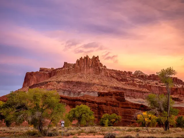
Torrey is a good place to stop overnight - it's a small town just west of Capitol Reef. Skyview Hotel is a small boutique property with a rooftop stargazing terrace and views of the red rock cliffs from your patio.
Torrey sits in a certified dark sky community and the hotel is just outside town, so after four days of canyon walls, you can spend the last night looking at the Milky Way if the weather gods are on your side.
The next morning keep going along Highway 24 east to I-70 and head back home to Denver. The drive is about 7 hours through the Utah desert and back over the Rockies.
This trip combines well with:
If you're still deciding where to go, there's more road trip ideas in my Denver road trip guide - including shorter drives in the Rockies or trips to Yellowstone and Mount Rushmore.

Sasha Yanshin – Founder & Lead Driver
Sasha Yanshin has spent the last 15+ years mapping and driving thousands of miles across Europe and the US. As the Founder and Lead Driver of Lazytrips, he brings an analytical approach to road-tripping, sharing meticulously tested routes, realistic drive times, and the hard-earned logistical reality of the open road.
Read full bio